Category:Stationsweg 16, 's-Hertogenbosch
Jump to navigation
Jump to search
| Object location | | View all coordinates using: OpenStreetMap |
|---|
building in 's-Hertogenbosch, Netherlands  | |||||
| Upload media | |||||
| Instance of | |||||
|---|---|---|---|---|---|
| Location | 's-Hertogenbosch, North Brabant, Netherlands | ||||
| Street address |
| ||||
| Located on street | |||||
| Heritage designation |
| ||||
 | |||||
|
This is a category about rijksmonument number 21869
|
| Address |
|
Media in category "Stationsweg 16, 's-Hertogenbosch"
The following 4 files are in this category, out of 4 total.
-
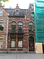 's-Hertogenbosch Rijksmonument 21869 Stationsweg 16.JPG 2,736 × 3,648; 3.29 MB
-
 Overzicht - 's-Hertogenbosch - 20110876 - RCE.jpg 1,200 × 788; 195 KB
-
 Overzicht - 's-Hertogenbosch - 20110877 - RCE.jpg 1,200 × 788; 226 KB
-
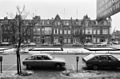 Overzicht - 's-Hertogenbosch - 20110879 - RCE.jpg 1,200 × 788; 212 KB


