Category:Steinkreuz Lind (Oberviechtach)
Jump to navigation
Jump to search
| Object location | | View all coordinates using: OpenStreetMap |
|---|
 | |||||
| Upload media | |||||
| Instance of | |||||
|---|---|---|---|---|---|
| Location | Oberviechtach, Schwandorf, Upper Palatinate, Bavaria, Germany | ||||
| Street address |
| ||||
| Heritage designation | |||||
 | |||||
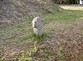
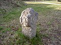
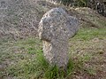
This is the category of the Bavarian Baudenkmal (cultural heritage monument) with the ID D-3-76-151-50 (Wikidata)
|
Media in category "Steinkreuz Lind (Oberviechtach)"
The following 6 files are in this category, out of 6 total.
-
 LindSteinkreuz 01.JPG 2,304 × 1,704; 907 KB
-
 LindSteinkreuz 02.JPG 2,304 × 1,704; 903 KB
-
 LindSteinkreuz 03.JPG 2,304 × 1,704; 898 KB
-
 LindSteinkreuz 04.JPG 2,304 × 1,704; 850 KB
-
 LindSteinkreuz 05.JPG 2,304 × 1,704; 860 KB
-
 LindSteinkreuz 06.JPG 2,304 × 1,704; 896 KB


