Category:Stenendam 1, Dokkum
Jump to navigation
Jump to search
| Object location | | View all coordinates using: OpenStreetMap |
|---|
 | |||||
| Upload media | |||||
| Instance of |
| ||||
|---|---|---|---|---|---|
| Location | Dokkum, Noardeast-Fryslân, Friesland, Netherlands | ||||
| Street address |
| ||||
| Located on street | |||||
| Heritage designation |
| ||||
 | |||||
|
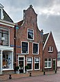
This is a category about rijksmonument number 13173
|
| Address |
|
Media in category "Stenendam 1, Dokkum"
The following 5 files are in this category, out of 5 total.
-
 Dokkum, Stiennendaam 1.jpg 2,030 × 2,773; 2.03 MB
-
 Gevels - Dokkum - 20059083 - RCE.jpg 1,200 × 805; 199 KB
-
 Stenendam 1, Dokkum.JPG 3,024 × 4,032; 2.39 MB
-
 Tegenover Stenendam - Dokkum - 20059091 - RCE.jpg 971 × 1,200; 244 KB
-
 Woonhuis Stenendam 1 Dokkum..JPG 3,456 × 4,608; 2.32 MB


