Category:Suisun Bay
Naar navigatie springen
Naar zoeken springen
English: The Suisun Bay, at the confluence of the Sacramento River and San Joaquin River in the Central Valley of California.
bay on the California coast of the United States  | |||||
| Media uploaden | |||||
| Is een | |||||
|---|---|---|---|---|---|
| Locatie | Californië, Pacific States Region | ||||
| Sluit aan op | |||||
| Instroom | |||||
| Stroomgebiedsland | |||||
 | |||||
Ondercategorieën
Deze categorie bevat de volgende 5 subcategorieën, van de 5 in totaal.
Media in categorie "Suisun Bay"
Deze categorie bevat de volgende 18 bestanden, van in totaal 18.
-
 Suisun Marsh Water Control.png 967 × 724; 139 kB
-
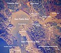 Wpdms nasa photo san pablo bay.jpg 534 × 467; 91 kB
-
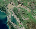
 Wpdms usgs photo sacramento delta 2.jpg 700 × 520; 81 kB
-
 Bay Area by Sentinel-2, 2019-03-11 (big version).jpg 20.389 × 21.539; 487,33 MB
-
 Bay Area by Sentinel-2, 2019-03-11 (small version).jpg 10.200 × 10.776; 123,14 MB
-
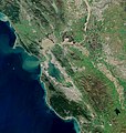
 BayareaUSGS.jpg 769 × 798; 613 kB
-
 Building a New Suisun Bridge 2.jpg 1.280 × 960; 187 kB
-

-

-
 Green sturgeon (28599196296).png 298 × 531; 226 kB
-
 Map of Suisun Bay- Port Chicago and Vicinity 1st Edition - NARA - 84785936.jpg 13.226 × 10.816; 11,73 MB
-
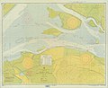 Map of Suisun Bay- Port Chicago and Vicinity 2nd Edition - NARA - 84785930.jpg 13.181 × 10.816; 9,64 MB
-
 Map of Suisun Bay- Port Chicago and Vicinity 5th Edition - NARA - 84785934.jpg 13.274 × 10.816; 10,07 MB
-
 NASA Worldwind, USGS imagery map, Hammond Island, California.png 3.400 × 1.700; 7,53 MB
-
 NASA Worldwind, USGS imagery map, Joice Island, California.png 1.500 × 1.500; 2,51 MB
-
 USGS survey map, Van Sickle Island, 1918.png 1.000 × 1.000; 2,15 MB
-
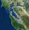
 View of the Bay Area and the Californian Delta.jpg 6.034 × 4.838; 39,04 MB
-
 California Grizzly Bear walking in the Delta Region.jpg 700 × 520; 261 kB


.jpg)
.jpg)


.png)


.jpg)