Category:Sundridge, Kent
Jump to navigation
Jump to search
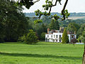
English: Sundridge is a village within the civil parish of Sundridge with Ide Hill, in the Sevenoaks District of Kent, England. The village is located on the A25 road to the east of Westerham. It should not be confused with Sundridge in southeast London (historically also in Kent).
village in Kent, United Kingdom  | |||||
| Upload media | |||||
| Instance of |
| ||||
|---|---|---|---|---|---|
| Location | Sundridge with Ide Hill, Sevenoaks, Kent, South East England, England | ||||
 | |||||
Subcategories
This category has the following 3 subcategories, out of 3 total.
Media in category "Sundridge, Kent"
The following 14 files are in this category, out of 14 total.
-
 Access road to Sundridge Place Farm - geograph.org.uk - 1670540.jpg 2,580 × 1,932; 1.91 MB
-
 Anne Seymour Damer. A woman of art and fashion, 1748-1828 (1908) (14576531980).jpg 3,120 × 2,084; 2.04 MB
-
 Chapmans Farm and Well Cottage - geograph.org.uk - 1670536.jpg 2,580 × 1,932; 1.49 MB
-
 Church Road near Birchfield Wood - geograph.org.uk - 1535114.jpg 640 × 427; 114 KB
-
 Church Road, Sundridge - geograph.org.uk - 1553285.jpg 640 × 480; 98 KB
-

-
 Footpath junction on a bridleway near Sundridge Place Farm - geograph.org.uk - 1670547.jpg 2,580 × 1,932; 1.38 MB
-
 Footpath to St Mary's Church - geograph.org.uk - 1670549.jpg 2,580 × 1,932; 1.55 MB
-
 Old Rectory, Sundridge-geograph.org-2561033.jpg 640 × 480; 117 KB
-
 Straight bridleway in Birchfield Wood - geograph.org.uk - 1535126.jpg 640 × 427; 115 KB
-
 Stream near Sundridge Place Farm - geograph.org.uk - 1670544.jpg 2,580 × 1,932; 1.27 MB
-
 Sundridge Memorial - geograph.org.uk - 19978.jpg 640 × 480; 136 KB
-
 Sundridge Village Sign - geograph.org.uk - 1670529.jpg 1,932 × 2,580; 2.02 MB
-
 Works entrance, Sundridge - geograph.org.uk - 2702528.jpg 640 × 430; 82 KB

_(14576531980).jpg)


