Category:Sundridge with Ide Hill
Aller à la navigation
Aller à la recherche
English: Sundridge and Ide Hill is a civil parish in the Sevenoaks District of Kent, England. It is located in the Darenth valley and lies between Sevenoaks and Westerham. The parish contains the two villages, Sundridge and Ide Hill, and is in an Area of Outstanding Natural Beauty, within London’s Green Belt.
localité britannique du comté anglais du Kent | |||||
| Téléverser des médias | |||||
| Nature de l’élément | |||||
|---|---|---|---|---|---|
| Nommé(e) en référence à | |||||
| Lieu | Sevenoaks, Kent, Angleterre du Sud-Est, Angleterre | ||||
 | |||||
Sous-catégories
Cette catégorie comprend 5 sous-catégories, dont les 5 ci-dessous.
Média dans la catégorie « Sundridge with Ide Hill »
Cette catégorie comprend 375 fichiers, dont les 200 ci-dessous.
(page précédente) (page suivante)-
 135-137 Main Road - geograph.org.uk - 3817746.jpg 800 × 530 ; 531 kio
-
 18 - 22, Church Rd (geograph 6716883).jpg 1 024 × 684 ; 183 kio
-
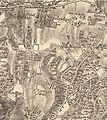 19th century map of Sundridge with Ide Hill.jpg 424 × 477 ; 84 kio
-
 211-217 Main Road - geograph.org.uk - 3822704.jpg 800 × 530 ; 423 kio
-
 A distinctive tree in Stubbs Wood - geograph.org.uk - 2472823.jpg 640 × 430 ; 157 kio
-
 A flooded Ovenden Road - geograph.org.uk - 3205363.jpg 4 000 × 3 000 ; 4,22 Mio
-
 Access Bridge, M25 - geograph.org.uk - 5844152.jpg 1 024 × 770 ; 137 kio
-
 Autumn along Ovenden Road - geograph.org.uk - 3205366.jpg 4 000 × 3 000 ; 4,3 Mio
-
 Autumnal tree along Ovenden Road - geograph.org.uk - 3205367.jpg 4 000 × 3 000 ; 4,26 Mio
-
 B2211 overbridge - geograph.org.uk - 2033976.jpg 640 × 430 ; 68 kio
-
 B2211 overbridge, M25 - geograph.org.uk - 2427997.jpg 640 × 430 ; 37 kio
-
 Baled hay for silage, Sundridge - geograph.org.uk - 2561078.jpg 640 × 480 ; 82 kio
-
 Barn near Ide Hill - geograph.org.uk - 2468105.jpg 640 × 430 ; 86 kio
-
 Barn, Dryhill Farm (geograph 6716198).jpg 1 024 × 684 ; 266 kio
-
 Barn, Sundridge Place (geograph 6716785).jpg 1 024 × 684 ; 171 kio
-
 Bends on Wheatsheaf Hill, Ide Hill - geograph.org.uk - 4618293.jpg 2 560 × 1 920 ; 1,99 Mio
-
 Big notice board, small notice - geograph.org.uk - 2561242.jpg 640 × 480 ; 138 kio
-
 Big William Cottage near Scollop Farm - geograph.org.uk - 1256544.jpg 640 × 430 ; 112 kio
-
 Birchwood Apartments, seen from New Road - geograph.org.uk - 4515153.jpg 4 000 × 3 000 ; 4,21 Mio
-
 Birchwood Apartments, seen from New Road - geograph.org.uk - 4515158.jpg 4 000 × 3 000 ; 4,23 Mio
-
 Birchwood Apartments, seen from New Road - geograph.org.uk - 4515164.jpg 4 000 × 3 000 ; 4,25 Mio
-
 Bishop's Cottage - geograph.org.uk - 3110640.jpg 640 × 425 ; 314 kio
-

-
 Boarhill - geograph.org.uk - 3400714.jpg 1 600 × 1 064 ; 447 kio
-
 Bough Beech KWT Reserve Visitor Centre - geograph.org.uk - 5984364.jpg 3 840 × 2 160 ; 3,4 Mio
-
 Bough Beech Reservoir from the Greensand Way - geograph.org.uk - 4023348.jpg 4 000 × 3 000 ; 3,93 Mio
-
 Brass of a civilian, St Mary's church, Sundridge - geograph.org.uk - 4311679.jpg 1 217 × 2 844 ; 3,23 Mio
-
 Brass of sons of Thomas Isley - geograph.org.uk - 4311837.jpg 1 600 × 1 054 ; 550 kio
-
 Brasted Lane - geograph.org.uk - 4515924.jpg 4 000 × 3 000 ; 4,27 Mio
-
 Brick building, Goathurst Common - geograph.org.uk - 2561267.jpg 640 × 480 ; 102 kio
-
 Bridge over the M25, west of junction 5 - geograph.org.uk - 2033958.jpg 640 × 360 ; 72 kio
-
 Bridleway beside Henden Manor Cottage - geograph.org.uk - 1862647.jpg 3 072 × 2 304 ; 1,68 Mio
-
 Bridleway goes west from Ide Hill Road - geograph.org.uk - 5060725.jpg 800 × 600 ; 172 kio
-
 Bridleway junction in Stubbs Wood - geograph.org.uk - 2470745.jpg 640 × 430 ; 144 kio
-
 Bridleway to Henden Manor - geograph.org.uk - 1862652.jpg 3 072 × 2 304 ; 1,44 Mio
-
 Brockhill Wood - geograph.org.uk - 4312645.jpg 640 × 480 ; 149 kio
-
 Brook Place - geograph.org.uk - 4023290.jpg 4 000 × 3 000 ; 4,36 Mio
-
 Brook Place Farmhouse (geograph 6727999).jpg 1 024 × 684 ; 212 kio
-
 Camberwell Lane, Ide Hill - geograph.org.uk - 4385998.jpg 2 560 × 1 920 ; 1,99 Mio
-
 Cattle track, Penn Farm - geograph.org.uk - 2561113.jpg 640 × 480 ; 94 kio
-
 Chains Farm - geograph.org.uk - 3400734.jpg 1 600 × 1 064 ; 516 kio
-
 Chapmans Road, Brasted, Kent - geograph.org.uk - 1096104.jpg 640 × 427 ; 55 kio
-
 Chevening Road - geograph.org.uk - 3817732.jpg 800 × 530 ; 557 kio
-
 Chevening Road at the junction of the M25, Sundridge - geograph.org.uk - 3941318.jpg 2 304 × 1 728 ; 845 kio
-
 Chevening Road bridge, M25 - geograph.org.uk - 2609045.jpg 640 × 430 ; 41 kio
-
 Chevening Road Bridge, M25 - geograph.org.uk - 4505961.jpg 640 × 426 ; 51 kio
-
 Chevening Road Bridge, M25 - geograph.org.uk - 5114789.jpg 640 × 493 ; 53 kio
-
 Chevening Road Bridge, M25 - geograph.org.uk - 5701795.jpg 640 × 426 ; 57 kio
-
 Chevening Road Bridge, M25 - geograph.org.uk - 5844150.jpg 1 024 × 681 ; 106 kio
-
 Cheving Road Bridge, M25 - geograph.org.uk - 5034364.jpg 640 × 426 ; 57 kio
-
 Church Road, Sundridge - geograph.org.uk - 1553287.jpg 640 × 480 ; 107 kio
-
 Clockwise M25, Combe Bank Drive Bridge - geograph.org.uk - 3732374.jpg 640 × 480 ; 252 kio
-
 Closed post office in Ide Hill - geograph.org.uk - 4621267.jpg 2 560 × 1 920 ; 1,53 Mio
-
 Combe Bank Drive - geograph.org.uk - 3817738.jpg 800 × 530 ; 505 kio
-
 Combe Bank Drive overbridge, M25 - geograph.org.uk - 2427999.jpg 640 × 430 ; 27 kio
-
 Combe Bank Drive, Sundridge - geograph.org.uk - 3941766.jpg 2 304 × 1 728 ; 794 kio
-
 Combe Bank Drive, Sundridge - geograph.org.uk - 3941767.jpg 2 304 × 1 728 ; 792 kio
-
 Combe Bank Farm - geograph.org.uk - 1888997.jpg 640 × 426 ; 109 kio
-
 Combe Bank Farm - geograph.org.uk - 3276252.jpg 640 × 425 ; 419 kio
-
 Combe Bank Farm - geograph.org.uk - 4569270.jpg 640 × 426 ; 70 kio
-
 Coombe Bank Drive Bridge, M25 - geograph.org.uk - 4505968.jpg 640 × 426 ; 50 kio
-
 Cooper’s Corner, postbox № TN14 209 - geograph.org.uk - 2739949.jpg 480 × 640 ; 62 kio
-
 Coppiced trees, Hanging Bank - geograph.org.uk - 2470734.jpg 640 × 430 ; 148 kio
-
 Coppicing, Hanging Bank - geograph.org.uk - 2470753.jpg 640 × 430 ; 138 kio
-
 Coppicing, Stubbs Wood - geograph.org.uk - 2470743.jpg 640 × 430 ; 143 kio
-
 Cottage on Sundridge Road, Ide Hill - geograph.org.uk - 4386982.jpg 2 560 × 1 920 ; 1,99 Mio
-
 Cottage, Main Road - geograph.org.uk - 3110638.jpg 640 × 425 ; 356 kio
-
 Cottages, Faulkner Hill Farm - geograph.org.uk - 1256535.jpg 640 × 430 ; 89 kio
-
 Country Road - geograph.org.uk - 4405186.jpg 640 × 430 ; 122 kio
-
 Countryside between Toy's Hill and Ide Hill - geograph.org.uk - 2467985.jpg 640 × 430 ; 78 kio
-
 Countryside near Ide Hill - geograph.org.uk - 2467993.jpg 640 × 430 ; 69 kio
-
 Countryside near Ide Hill - geograph.org.uk - 6277722.jpg 4 000 × 3 000 ; 4,65 Mio
-
 Countryside west of Bough Beech Reservoir - geograph.org.uk - 2110620.jpg 640 × 430 ; 133 kio
-
 CowParade cow at Henden Manor Farm - geograph.org.uk - 4461155.jpg 4 000 × 3 000 ; 3,98 Mio
-
 Crop Field off Pilgrims Way - geograph.org.uk - 1993648.jpg 1 024 × 768 ; 218 kio
-
 Cross, Coronation Gardens - geograph.org.uk - 3817729.jpg 530 × 800 ; 599 kio
-
 Cross, Coronation Gardens - geograph.org.uk - 3817731.jpg 530 × 800 ; 439 kio
-
 Dibgate Farm, Sundridge - geograph.org.uk - 4047400.jpg 2 816 × 2 112 ; 2,12 Mio
-
 Double gates on to private drive - geograph.org.uk - 5992333.jpg 3 840 × 2 160 ; 4,66 Mio
-
 Driveway to Shootfield - geograph.org.uk - 1884473.jpg 640 × 426 ; 113 kio
-
 Dryhill Cottage (geograph 6716647).jpg 1 024 × 685 ; 193 kio
-
 Dryhill Farm - geograph.org.uk - 4405165.jpg 640 × 430 ; 72 kio
-
 Dryhill Farm - geograph.org.uk - 4406147.jpg 640 × 430 ; 94 kio
-
 Dryhill Farmhouse (geograph 6716199).jpg 1 024 × 684 ; 189 kio
-
 Dryhill Lane - geograph.org.uk - 3550560.jpg 3 338 × 2 562 ; 1,5 Mio
-
 Dwelling by Scollops Farm - geograph.org.uk - 5061191.jpg 800 × 600 ; 138 kio
-
 Eastwood Cottages across a field - geograph.org.uk - 1256501.jpg 640 × 430 ; 53 kio
-
 Elan House - geograph.org.uk - 2468134.jpg 640 × 430 ; 40 kio
-
 Emmets Lane at the junction of Sundridge Road - geograph.org.uk - 4385937.jpg 2 560 × 1 920 ; 2 Mio
-
 Ferry Cottage and Inglenook Cottage - geograph.org.uk - 3822727.jpg 800 × 530 ; 413 kio
-
 Field beside New Road, Brasted - geograph.org.uk - 4413757.jpg 640 × 427 ; 93 kio
-
 Field boundary parallel with Ide Hill Road - geograph.org.uk - 5061184.jpg 800 × 600 ; 151 kio
-
 Field by the M25, Chevening - geograph.org.uk - 2591601.jpg 1 600 × 1 200 ; 499 kio
-
 Field north of Norman Street - geograph.org.uk - 2561152.jpg 640 × 480 ; 115 kio
-
 Field view near Wink Hurst - geograph.org.uk - 3969122.jpg 4 000 × 3 000 ; 4 Mio
-
 Fields belonging to Faulkners Hill Farm - geograph.org.uk - 4181349.jpg 4 000 × 3 000 ; 3,94 Mio
-
 Flooding on Ovenden Road - geograph.org.uk - 3205362.jpg 4 000 × 3 000 ; 4,3 Mio
-
 Footbridge, Greensand Way - geograph.org.uk - 2467970.jpg 640 × 430 ; 133 kio
-

-
 Footpath on the edge of Birchfield Wood - geograph.org.uk - 4515861.jpg 4 000 × 3 000 ; 4,31 Mio
-
 Footpath signpost, Bough Beech Visitors Centre - geograph.org.uk - 2110625.jpg 640 × 430 ; 177 kio
-
 Footpath south of Manor Farm - geograph.org.uk - 2560874.jpg 640 × 480 ; 187 kio
-

-
 Footpath to Dryhill Lane - geograph.org.uk - 3550416.jpg 4 000 × 3 000 ; 4,08 Mio
-
 Footpath to Emmetts - geograph.org.uk - 3400699.jpg 1 600 × 1 064 ; 453 kio
-
 Footpath to Ide Hill - geograph.org.uk - 4022539.jpg 4 000 × 3 000 ; 4,24 Mio
-
 Footpath to Norman Street - geograph.org.uk - 4022504.jpg 4 000 × 3 000 ; 3,84 Mio
-
 Footpath to Scollops Farm - geograph.org.uk - 4181369.jpg 4 000 × 3 000 ; 4,07 Mio
-
 Footpath to the Greensand Ridge - geograph.org.uk - 4181240.jpg 4 000 × 3 000 ; 3,98 Mio
-
 Footpath to Willow Wood - geograph.org.uk - 4022563.jpg 4 000 × 3 000 ; 4,13 Mio
-
 Footpath to Winkhurst Green - geograph.org.uk - 2110621.jpg 640 × 430 ; 182 kio
-
 Footpath towards Ide Hill (2) - geograph.org.uk - 1947903.jpg 3 072 × 2 304 ; 2,28 Mio
-
 Footpath towards Ide Hill - geograph.org.uk - 1947897.jpg 3 072 × 2 304 ; 2,3 Mio
-
 Footpath towards Norman Street - geograph.org.uk - 1947888.jpg 3 072 × 2 304 ; 2,54 Mio
-
 Gate on footpath at corner of woodland - geograph.org.uk - 5061200.jpg 800 × 600 ; 157 kio
-

-
 Grasshopper Sculpture - geograph.org.uk - 5984367.jpg 1 810 × 2 432 ; 1,8 Mio
-
 Green Lane on the way to Bore Place - geograph.org.uk - 3969124.jpg 4 000 × 3 000 ; 4,34 Mio
-
 Green Oak Barn, Warren Farm - geograph.org.uk - 3110651.jpg 640 × 425 ; 290 kio
-
 Greensand Way entering Ide Hill - geograph.org.uk - 2468108.jpg 640 × 430 ; 104 kio
-
 Greensand Way enters Ide Hill Woodland - geograph.org.uk - 1947931.jpg 3 072 × 2 304 ; 1,29 Mio
-
 Greensand Way signed off Nightingale Lane - geograph.org.uk - 2472795.jpg 640 × 430 ; 140 kio
-
 Greensand Way to Ide Hill - geograph.org.uk - 2467976.jpg 640 × 430 ; 93 kio
-
 Greensand Way to Ide Hill - geograph.org.uk - 2467989.jpg 640 × 430 ; 70 kio
-
 Greensand Way to Ide Hill - geograph.org.uk - 2467997.jpg 640 × 430 ; 66 kio
-
 Greensand Way to Ide Hill - geograph.org.uk - 2468074.jpg 640 × 430 ; 85 kio
-
 Greensand Way, Hanging Bank - geograph.org.uk - 2470724.jpg 640 × 430 ; 158 kio
-
 Greensand Way, Hanging Bank - geograph.org.uk - 2470732.jpg 640 × 430 ; 145 kio
-
 Greensand Way, Hanging Bank - geograph.org.uk - 2470751.jpg 640 × 430 ; 142 kio
-
 Greensand Way, Hanging Bank - geograph.org.uk - 2472807.jpg 640 × 430 ; 137 kio
-
 Greensand Way, Stubbs Wood - geograph.org.uk - 2470740.jpg 640 × 430 ; 149 kio
-
 Greensand Way, Stubbs Wood - geograph.org.uk - 2470748.jpg 640 × 430 ; 133 kio
-
 Greensand Way, Stubbs Wood - geograph.org.uk - 2472816.jpg 640 × 430 ; 150 kio
-
 Hanging Bank - geograph.org.uk - 2470726.jpg 640 × 430 ; 157 kio
-
 Hanging Bank - geograph.org.uk - 2472805.jpg 640 × 430 ; 158 kio
-
 Hanging Bank Information Board - geograph.org.uk - 2470754.jpg 640 × 430 ; 75 kio
-
 Hawks Wood - geograph.org.uk - 2145580.jpg 640 × 480 ; 187 kio
-

-
 Hendon Manor Farm - geograph.org.uk - 2100858.jpg 14 435 × 2 300 ; 7,34 Mio
-
 Home Farm - geograph.org.uk - 1879863.jpg 640 × 426 ; 81 kio
-
 Home Farm - geograph.org.uk - 1889010.jpg 640 × 426 ; 105 kio
-
 House on Ide Hill Road - geograph.org.uk - 4386305.jpg 2 560 × 1 920 ; 2,11 Mio
-
 House on New Road, Sundridge - geograph.org.uk - 4619478.jpg 2 560 × 1 920 ; 2,11 Mio
-
 House on Rycroft Lane, Goathurst Common - geograph.org.uk - 4618596.jpg 2 532 × 1 882 ; 1,26 Mio
-
 House on the village green, Ide Hill - geograph.org.uk - 3400703.jpg 1 600 × 1 064 ; 425 kio
-
 House on Wheatsheaf Hill - geograph.org.uk - 2470707.jpg 640 × 430 ; 105 kio
-
 Houses in Ide Hill - geograph.org.uk - 4618599.jpg 2 482 × 1 812 ; 1,2 Mio
-
 Ide Cottage on the village green at Ide Hill - geograph.org.uk - 4022494.jpg 4 000 × 3 000 ; 3,96 Mio
-
 Ide Hill from Emmetts Garden - geograph.org.uk - 5380940.jpg 3 678 × 2 456 ; 5,41 Mio
-
 Ide Hill village centre - geograph.org.uk - 4385983.jpg 2 560 × 1 920 ; 1,98 Mio
-
 Ide Hill, mid March 2017 - geograph.org.uk - 5337998.jpg 640 × 480 ; 48 kio
-
 Ide Hill, overlooking Bough Beech Reservoir - geograph.org.uk - 2205765.jpg 1 067 × 750 ; 407 kio
-
 Ide House - geograph.org.uk - 2468122.jpg 640 × 430 ; 57 kio
-
 Judge's Cottages - geograph.org.uk - 3110641.jpg 640 × 425 ; 344 kio
-
 Junction on Ide Hill Road - geograph.org.uk - 4386021.jpg 2 560 × 1 920 ; 2,02 Mio
-
 Junction with Ide Hill Road - geograph.org.uk - 2561306.jpg 640 × 480 ; 128 kio
-
 Keeper's Cottage, Goathurst Common - geograph.org.uk - 2472798.jpg 640 × 430 ; 137 kio
-
 Lane below Yorkshill - geograph.org.uk - 2748545.jpg 640 × 428 ; 151 kio
-
 Lane junction by the village hall - geograph.org.uk - 2470660.jpg 640 × 430 ; 60 kio
-
 Lane near Goathurst Common - geograph.org.uk - 2788029.jpg 4 320 × 3 240 ; 4,07 Mio
-
 Lane near Ide Hill - geograph.org.uk - 1553351.jpg 640 × 480 ; 69 kio
-
 Lane near Scollops Farm - geograph.org.uk - 4181223.jpg 4 000 × 3 000 ; 4,27 Mio
-
 Lane north of Scallops Farm - geograph.org.uk - 1256552.jpg 640 × 430 ; 106 kio
-
 Lane off the A25 near Dryhill - geograph.org.uk - 2702525.jpg 640 × 501 ; 55 kio
-
 Lane through Ide Hill - geograph.org.uk - 2470653.jpg 640 × 430 ; 103 kio
-
 Lane to Sundridge, Ide Hill - geograph.org.uk - 1553341.jpg 640 × 480 ; 105 kio
-
 Lane to Yorks Hill - geograph.org.uk - 2787997.jpg 4 320 × 3 240 ; 3,72 Mio
-
 Lane towards Scallops Farm - geograph.org.uk - 2561286.jpg 640 × 428 ; 137 kio
-
 Little Norman Street Farmhouse (geograph 6727991).jpg 1 024 × 684 ; 147 kio
-
 Log hide, Hanging Bank - geograph.org.uk - 2470747.jpg 640 × 430 ; 136 kio
-
 London Countryway in Kent (188) - geograph.org.uk - 5061391.jpg 800 × 600 ; 84 kio
-
 London Countryway in Kent (189) - geograph.org.uk - 5061410.jpg 800 × 600 ; 186 kio
-
 London Countryway in Kent (190) - geograph.org.uk - 5061421.jpg 800 × 600 ; 194 kio
-
 London Countryway in Kent (191) - geograph.org.uk - 5061432.jpg 800 × 600 ; 211 kio
-
 London Countryway in Kent (192) - geograph.org.uk - 5061438.jpg 800 × 600 ; 215 kio
-
 London Countryway in Kent (193) - geograph.org.uk - 5061447.jpg 800 × 600 ; 159 kio
-
 London Countryway in Kent (194) - geograph.org.uk - 5061466.jpg 800 × 600 ; 172 kio
-
 London Countryway in Kent (195) - geograph.org.uk - 5061478.jpg 800 × 600 ; 168 kio
-
 London Countryway in Kent (196) - geograph.org.uk - 5061483.jpg 800 × 600 ; 136 kio
-
 London Countryway in Kent (197) - geograph.org.uk - 5061491.jpg 800 × 600 ; 156 kio
-
 London Countryway in Kent (198) - geograph.org.uk - 5061501.jpg 800 × 600 ; 110 kio
-
 London Countryway in Kent (199) - geograph.org.uk - 5061508.jpg 800 × 600 ; 190 kio
-
 London Countryway in Kent (200) - geograph.org.uk - 5061513.jpg 800 × 600 ; 178 kio
-
 London Countryway in Kent (201) - geograph.org.uk - 5061519.jpg 800 × 600 ; 113 kio
-
 London Countryway in Kent (202) - geograph.org.uk - 5061525.jpg 800 × 600 ; 206 kio
-
 London Countryway in Kent (203) - geograph.org.uk - 5061537.jpg 800 × 600 ; 143 kio
-
 London Countryway in Kent (204) - geograph.org.uk - 5061549.jpg 800 × 600 ; 172 kio
-
 London Countryway in Kent (205) - geograph.org.uk - 5061559.jpg 800 × 600 ; 208 kio
-
 London Countryway in Kent (206) - geograph.org.uk - 5061564.jpg 800 × 600 ; 216 kio
-
 London Countryway in Kent (207) - geograph.org.uk - 5061567.jpg 800 × 600 ; 230 kio
-
 London Countryway in Kent (208) - geograph.org.uk - 5061568.jpg 800 × 600 ; 177 kio
-
 London Countryway in Kent (209) - geograph.org.uk - 5061570.jpg 800 × 600 ; 178 kio
-
 Looking down Ovenden Road - geograph.org.uk - 5181371.jpg 4 233 × 3 175 ; 3,31 Mio
-

-

-
 Looking towards Emmetts - geograph.org.uk - 4022507.jpg 4 000 × 3 000 ; 3,68 Mio
-
 Looking towards Long Meadow Farm - geograph.org.uk - 4181378.jpg 4 000 × 3 000 ; 4,27 Mio
-
 Looking towards the green at Whitley Row - geograph.org.uk - 4023283.jpg 4 000 × 3 000 ; 3,92 Mio
-
 Looking towards the Greensand Ridge - geograph.org.uk - 3969114.jpg 4 000 × 3 000 ; 4,13 Mio
-
 Looking up Sundridge Hill - geograph.org.uk - 3205336.jpg 4 000 × 3 000 ; 4,01 Mio

.jpg)


.jpg)
.jpg)


.jpg)


.jpg)


.jpg)


_-_geograph.org.uk_-_1947903.jpg)


.jpg)

_-_geograph.org.uk_-_5061391.jpg)
_-_geograph.org.uk_-_5061410.jpg)
_-_geograph.org.uk_-_5061421.jpg)
_-_geograph.org.uk_-_5061432.jpg)
_-_geograph.org.uk_-_5061438.jpg)
_-_geograph.org.uk_-_5061447.jpg)
_-_geograph.org.uk_-_5061466.jpg)
_-_geograph.org.uk_-_5061478.jpg)
_-_geograph.org.uk_-_5061483.jpg)
_-_geograph.org.uk_-_5061491.jpg)
_-_geograph.org.uk_-_5061501.jpg)
_-_geograph.org.uk_-_5061508.jpg)
_-_geograph.org.uk_-_5061513.jpg)
_-_geograph.org.uk_-_5061519.jpg)
_-_geograph.org.uk_-_5061525.jpg)
_-_geograph.org.uk_-_5061537.jpg)
_-_geograph.org.uk_-_5061549.jpg)
_-_geograph.org.uk_-_5061559.jpg)
_-_geograph.org.uk_-_5061564.jpg)
_-_geograph.org.uk_-_5061567.jpg)
_-_geograph.org.uk_-_5061568.jpg)
_-_geograph.org.uk_-_5061570.jpg)


