Category:Sutton, Cheshire East
Jump to navigation
Jump to search
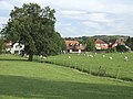
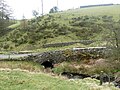
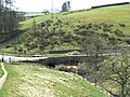
English: Sutton is a civil parish in the unitary authority of Cheshire East and the ceremonial county of Cheshire, England that is situated roughly a mile south of Macclesfield, it includes the village of Sutton Lane Ends and the hamlets of Gurnett and Jarman. The rivers Bollin and Rosendale run through Sutton Lane Ends, as does the Macclesfield Canal.
civil parish in Cheshire East, Cheshire, England | |||||
| Upload media | |||||
| Instance of | |||||
|---|---|---|---|---|---|
| Location | Cheshire East, Cheshire, North West England, England | ||||
| Population |
| ||||
 | |||||
Subcategories
This category has the following 10 subcategories, out of 10 total.
A
- Arighi Bianchi, Macclesfield (14 F)
L
M
O
R
- Ridgegate Reservoir (27 F)
S
T
- Tegg's Nose Country Park (56 F)
- Trentabank Reservoir (24 F)
Media in category "Sutton, Cheshire East"
The following 200 files are in this category, out of 460 total.
(previous page) (next page)-

-
 A lot of daffs - geograph.org.uk - 4961046.jpg 4,000 × 3,000; 5.21 MB
-
 Above Hollin Lane - geograph.org.uk - 1943927.jpg 1,280 × 854; 474 KB
-
 Above Lowerhouse Farm, Hollins Lane - geograph.org.uk - 2901246.jpg 5,184 × 3,456; 4.8 MB
-
 Access to Topclose Farm - geograph.org.uk - 3028759.jpg 640 × 427; 251 KB
-
 Alder (Alnus glutinosa) - geograph.org.uk - 4283156.jpg 1,800 × 1,200; 357 KB
-
 Along Highmoor Brook - geograph.org.uk - 4960805.jpg 4,000 × 3,000; 5.08 MB
-
 Approaching Nessit Hill - geograph.org.uk - 4762653.jpg 1,200 × 900; 169 KB
-
 At the Milk Bar - geograph.org.uk - 5383172.jpg 2,610 × 1,724; 1.99 MB
-
 At the summit - geograph.org.uk - 5786364.jpg 3,426 × 2,488; 2.84 MB
-

-

-
 B & B - geograph.org.uk - 5391754.jpg 2,958 × 2,101; 2.29 MB
-
 Backridges Farm - geograph.org.uk - 5758583.jpg 1,280 × 874; 209 KB
-
 Barn at Higher Pethills Farm - geograph.org.uk - 4283158.jpg 1,800 × 1,200; 315 KB
-
 Barn at Hollins Farm, nr Macclesfield.jpg 4,000 × 3,000; 1.43 MB
-
 Barn by Clough House below Tegg's Nose - geograph.org.uk - 5621919.jpg 5,184 × 2,920; 6.44 MB
-
 Below Sutton Reservoir - geograph.org.uk - 4111236.jpg 1,800 × 1,200; 1.24 MB
-
 Beyond Croker - geograph.org.uk - 3172577.jpg 3,456 × 2,304; 2.89 MB
-
 Big ears - geograph.org.uk - 5383079.jpg 2,759 × 2,174; 2.3 MB
-
 Bollinhead Lane near Brindhurst Farm - geograph.org.uk - 6604773.jpg 3,024 × 4,032; 2.63 MB
-
 Bottoms Reservoir - geograph.org.uk - 1249218.jpg 640 × 480; 66 KB
-
 Bottoms reservoir - geograph.org.uk - 2248575.jpg 640 × 282; 30 KB
-
 Bottoms Reservoir - geograph.org.uk - 3028681.jpg 640 × 427; 263 KB
-
 Bottoms Reservoir - geograph.org.uk - 3703776.jpg 3,872 × 2,592; 1.94 MB
-
 Bottoms Reservoir - geograph.org.uk - 3878208.jpg 3,888 × 2,296; 1.4 MB
-
 Bottoms Reservoir - geograph.org.uk - 4489185.jpg 1,200 × 800; 1.04 MB
-
 Bottoms Reservoir - geograph.org.uk - 5840306.jpg 1,024 × 683; 156 KB
-
 Bottoms Reservoir and Gritstone Trail, Langley - geograph.org.uk - 5757988.jpg 1,280 × 960; 435 KB
-
 Bottoms Reservoir and Tegg's Nose, Langley - geograph.org.uk - 5298129.jpg 1,024 × 682; 154 KB
-
 Bottoms Reservoir, Langley - geograph.org.uk - 5621920.jpg 5,184 × 2,920; 6.43 MB
-
 Bottoms Reservoir, Langley - geograph.org.uk - 6604729.jpg 4,032 × 3,024; 1.88 MB
-
 Bottoms Reservoir, Langley - view to Redhouses - geograph.org.uk - 5621922.jpg 5,184 × 2,920; 6.04 MB
-
 Bottoms Reservoir, Langley ^ view towards Tegg's Nose - geograph.org.uk - 6338825.jpg 5,184 × 2,920; 5.47 MB
-
 Bottoms Reservoir, Langley ^ view towards Tegg's Nose - geograph.org.uk - 6338828.jpg 5,184 × 2,920; 5.05 MB
-
 Bottoms Reservoir, Langley, Macclesfield - geograph.org.uk - 2838706.jpg 5,184 × 3,456; 3.11 MB
-
 Boundary Stone, Cressbank Common - geograph.org.uk - 3028718.jpg 427 × 640; 279 KB
-
 Bridge between Lane Ends and Lee - geograph.org.uk - 4111309.jpg 1,800 × 1,200; 1.01 MB
-
 Bridge over Rossen Clough - geograph.org.uk - 4283149.jpg 1,800 × 1,200; 331 KB
-
 Bridle path to Brooms Farm - geograph.org.uk - 2898913.jpg 5,184 × 3,456; 4.65 MB
-
 Bridleway to Fox Bank - geograph.org.uk - 6256483.jpg 768 × 1,024; 137 KB
-
 Brown Hill - geograph.org.uk - 3028697.jpg 640 × 427; 209 KB
-
 Brown Hill - geograph.org.uk - 4739887.jpg 5,500 × 3,667; 6.31 MB
-
 Bull and two cows - geograph.org.uk - 2559493.jpg 3,648 × 2,736; 4.53 MB
-

-
 Bullock's Lane, Sutton - geograph.org.uk - 5760320.jpg 1,280 × 960; 537 KB
-
 Bullocks Lane near Gurnett, Cheshire - geograph.org.uk - 4281481.jpg 1,024 × 659; 354 KB
-
 By Higher Penthills Farm - geograph.org.uk - 6135623.jpg 768 × 1,024; 309 KB
-
 Byron's Lane in Gurnett, Cheshire - geograph.org.uk - 4283458.jpg 1,024 × 789; 361 KB
-
 Byrons Lane - Gurnett - geograph.org.uk - 2755668.jpg 3,580 × 2,488; 3.22 MB
-
 Cairn near Sutton Hall - geograph.org.uk - 5760325.jpg 1,280 × 827; 314 KB
-
 Canada geese south of Macclesfield, Cheshire - geograph.org.uk - 4275830.jpg 1,024 × 768; 470 KB
-
 Canada geese south of Macclesfield, Cheshire - geograph.org.uk - 4275831.jpg 768 × 1,024; 500 KB
-
 Canalside pasture near Lyme Green in Cheshire - geograph.org.uk - 6631083.jpg 1,440 × 960; 1.1 MB
-
 Canalside pasture near Lyme Green in Cheshire - geograph.org.uk - 6631105.jpg 1,280 × 960; 1.18 MB
-
 Canalside pasture near Sutton Lane Ends in Cheshire - geograph.org.uk - 6631075.jpg 1,440 × 960; 1.36 MB
-
 Cattle grazing in field below Hardings - geograph.org.uk - 2155200.jpg 1,024 × 768; 202 KB
-
 Cessbank Common - geograph.org.uk - 1943852.jpg 1,280 × 854; 288 KB
-
 Cheshire Fungi (5) - geograph.org.uk - 4754746.jpg 3,618 × 2,657; 5.55 MB
-
 Cheshire pasture near Sutton Lane Ends - geograph.org.uk - 6631057.jpg 960 × 1,280; 1.36 MB
-
 Cheshire pasture near Sutton Lane Ends - geograph.org.uk - 6631062.jpg 1,280 × 960; 1.33 MB
-
 Church House Inn, Sutton - geograph.org.uk - 2328599.jpg 2,272 × 1,704; 1,017 KB
-
 Church House, Sutton Lane Ends - geograph.org.uk - 3689514.jpg 1,600 × 1,064; 466 KB
-
 Civit Hills Farm access road - geograph.org.uk - 2898898.jpg 5,184 × 3,456; 5.51 MB
-
 Civit Hills Farm cattle grid - geograph.org.uk - 2898893.jpg 5,184 × 3,456; 3.48 MB
-
 Clarke Lane - geograph.org.uk - 3028686.jpg 640 × 427; 231 KB
-
 Clarke Lane, Langley - geograph.org.uk - 6607995.jpg 3,024 × 4,032; 1.61 MB
-
 Close Encounter - geograph.org.uk - 5383066.jpg 3,572 × 2,702; 6.34 MB
-
 Clough House Farm - geograph.org.uk - 2839950.jpg 5,184 × 3,456; 5.26 MB
-
 Conifers in snow - geograph.org.uk - 4762660.jpg 1,200 × 900; 340 KB
-
 Country Lane - geograph.org.uk - 4752842.jpg 5,500 × 3,667; 4.86 MB
-
 Cressbank Common - geograph.org.uk - 3028714.jpg 640 × 427; 235 KB
-
 Croker Farm - geograph.org.uk - 4285182.jpg 2,592 × 3,673; 1.81 MB
-
 Croker Farm and driveway - geograph.org.uk - 3172636.jpg 3,354 × 2,187; 3.62 MB
-
 Croker Hill - geograph.org.uk - 3878263.jpg 3,841 × 2,521; 1.26 MB
-
 Croker Hill - geograph.org.uk - 4283177.jpg 1,800 × 1,200; 315 KB
-
 Croker House - geograph.org.uk - 4285178.jpg 3,888 × 2,592; 1.79 MB
-
 Croker Lane end - geograph.org.uk - 2733490.jpg 4,000 × 3,000; 2.39 MB
-
 Danes Farm - geograph.org.uk - 4923385.jpg 3,072 × 1,728; 3.75 MB
-
 Datestone, former factory, Langley - geograph.org.uk - 5758318.jpg 1,280 × 960; 282 KB
-
 Defibrillator Box outside The Sutton Gamekeeper - geograph.org.uk - 6294985.jpg 1,024 × 769; 249 KB
-
 Descending from Sutton Common - geograph.org.uk - 4283193.jpg 1,800 × 1,200; 415 KB
-
 Descending to Lowerhouses - geograph.org.uk - 4283203.jpg 1,800 × 1,200; 565 KB
-
 Drinking trough - geograph.org.uk - 3172646.jpg 3,456 × 2,304; 2.63 MB
-
 Drive to Hollinset Farm - geograph.org.uk - 1943879.jpg 854 × 1,280; 303 KB
-
 Driveway to Sutton Hall near Gurnett, Cheshire - geograph.org.uk - 4281905.jpg 1,024 × 768; 561 KB
-
 Duck a l'orange?? - geograph.org.uk - 3934750.jpg 4,320 × 3,240; 5.04 MB
-
 Dusk at Ridgegate Reservoir, Macclesfield Forest - geograph.org.uk - 6338864.jpg 5,184 × 2,920; 3.29 MB
-
 Entering Higher Sutton - geograph.org.uk - 4919767.jpg 800 × 600; 196 KB
-
 Entry to Macclesfield Forest by Ridgegate Reservoir - geograph.org.uk - 4922617.jpg 3,072 × 1,728; 4.37 MB
-
 Erratic with bench mark, Croker Hill - geograph.org.uk - 6374374.jpg 5,184 × 2,920; 6.89 MB
-

-
 Face to face - geograph.org.uk - 5383073.jpg 3,117 × 2,851; 5.35 MB
-
 Farm outbuildings at Ridge Hall Farm - geograph.org.uk - 5758590.jpg 1,280 × 960; 586 KB
-
 Farmland and Bottoms Reservoir - geograph.org.uk - 4919332.jpg 800 × 600; 100 KB
-
 Feeder Stream - geograph.org.uk - 5385936.jpg 4,000 × 3,000; 5.09 MB
-
 Fence and oak tree - geograph.org.uk - 1943910.jpg 854 × 1,280; 431 KB
-
 Fern Lee Farm, Higher Sutton.jpg 4,000 × 3,000; 1.15 MB
-
 Fiddler's Ferry power station from the Peak District - geograph.org.uk - 4737744.jpg 5,500 × 3,667; 3.96 MB
-
 Field in the Rain - geograph.org.uk - 3028750.jpg 640 × 427; 215 KB
-

-
 Field view - geograph.org.uk - 6135624.jpg 1,024 × 768; 175 KB
-
 Field view - geograph.org.uk - 6135626.jpg 768 × 1,024; 117 KB
-
 Fields in morning light - geograph.org.uk - 3703737.jpg 3,872 × 2,592; 1.55 MB
-
 Footpath - geograph.org.uk - 385935.jpg 640 × 480; 165 KB
-
 Footpath above Hollin Lane - geograph.org.uk - 1943905.jpg 1,280 × 854; 365 KB
-
 Footpath alongside Sutton Reservoir - geograph.org.uk - 4111294.jpg 1,800 × 1,200; 1.38 MB
-
 Footpath at Sutton Reservoir - geograph.org.uk - 5760299.jpg 1,280 × 861; 408 KB
-
 Footpath closed - geograph.org.uk - 5758018.jpg 911 × 1,280; 344 KB
-
 Footpath closed - geograph.org.uk - 5758022.jpg 1,280 × 900; 437 KB
-
 Footpath leaving the Hanging Gate - geograph.org.uk - 3212693.jpg 3,872 × 2,592; 4.79 MB
-
 Footpath near Hollin Lane - geograph.org.uk - 1943919.jpg 1,280 × 854; 444 KB
-
 Footpath signpost in Macclesfield Forest - geograph.org.uk - 4919339.jpg 800 × 600; 194 KB
-
 Footpath steps - geograph.org.uk - 5758577.jpg 960 × 1,280; 582 KB
-
 Footpath to Backridges Farm - geograph.org.uk - 5758572.jpg 1,280 × 960; 471 KB
-
 Footpath to Langley from Ridge Hill - geograph.org.uk - 5758670.jpg 1,280 × 878; 280 KB
-
 Footpath to Longgutter - geograph.org.uk - 1943867.jpg 1,280 × 854; 302 KB
-
 Footpath to Sutton Lane Ends - geograph.org.uk - 4111306.jpg 1,800 × 1,200; 1.17 MB
-
 Footpath to Sutton Reservoir - geograph.org.uk - 4111241.jpg 1,800 × 1,200; 1.21 MB
-
 Footpath to Sutton Reservoir - geograph.org.uk - 4111312.jpg 1,800 × 1,200; 1.28 MB
-
 Footpath to Trentabank - geograph.org.uk - 2027349.jpg 640 × 426; 102 KB
-
 Forest track on Nessit Hill - geograph.org.uk - 5050822.jpg 1,469 × 1,102; 732 KB
-
 Former chapel at Sutton Hall near Macclesfield - geograph.org.uk - 6677252.jpg 5,184 × 2,912; 4.6 MB
-

-
 Foxbank Farm - geograph.org.uk - 2901236.jpg 5,184 × 3,456; 4.21 MB
-
 Foxbank Farm - geograph.org.uk - 4283146.jpg 1,800 × 1,200; 314 KB
-
 Foxbank Farm - geograph.org.uk - 4283201.jpg 1,800 × 1,200; 340 KB
-
 Foxbank, Higher Sutton.jpg 4,103 × 3,138; 970 KB
-
 Foxgloves in Macclesfield Forest - geograph.org.uk - 3028766.jpg 640 × 427; 299 KB
-
 Frosty morning at the summit of Tegg's Nose - geograph.org.uk - 6492516.jpg 1,799 × 1,199; 389 KB
-
 Gate repairs in Macclesfield Forest - geograph.org.uk - 2559336.jpg 3,648 × 2,736; 5.87 MB
-
 Gated road - geograph.org.uk - 1943930.jpg 1,280 × 854; 301 KB
-
 Gateway on Ridge Hill - geograph.org.uk - 5392044.jpg 1,600 × 1,067; 477 KB
-
 Gawsworth Common - geograph.org.uk - 4285174.jpg 3,888 × 2,592; 1.59 MB
-

-
 Geese heading off^ - geograph.org.uk - 5098768.jpg 2,000 × 1,529; 1.1 MB
-
 Gorse beside lane - geograph.org.uk - 5392791.jpg 1,600 × 1,067; 189 KB
-
 Gravestone, Cressbank Common - geograph.org.uk - 3028713.jpg 640 × 427; 220 KB
-
-
 Grazing Land, Mosslea Farm - geograph.org.uk - 6604761.jpg 1,200 × 1,600; 691 KB
-
 Great Oak Farm - geograph.org.uk - 3878275.jpg 3,888 × 2,592; 1.52 MB
-
 Great Oak Farm.jpg 3,888 × 2,452; 1.94 MB
-
 Greenbarn - geograph.org.uk - 4919326.jpg 800 × 600; 108 KB
-
 Greenway Bridge - geograph.org.uk - 2560460.jpg 3,648 × 2,736; 5.02 MB
-
 Greenway Bridge - geograph.org.uk - 4919208.jpg 800 × 600; 161 KB
-
 Greenway Bridge - geograph.org.uk - 4961037.jpg 3,954 × 2,965; 3.88 MB
-
 Gritstone Trail, Hill of Rossenclowes - geograph.org.uk - 2901193.jpg 5,184 × 3,456; 4.33 MB
-
 Gritstone Trail, Teggsnose Reservoir Dam - geograph.org.uk - 6602517.jpg 3,024 × 4,032; 1.42 MB
-
 Handsome Chap - geograph.org.uk - 4960810.jpg 4,000 × 3,000; 4.66 MB
-
 Hanginggate Farm - geograph.org.uk - 3878256.jpg 3,859 × 2,246; 1.44 MB
-
 Hanginggate Farm - geograph.org.uk - 3878262.jpg 3,888 × 2,312; 1.31 MB
-
 Hardingland and Ashtreetop - geograph.org.uk - 2840005.jpg 5,184 × 3,456; 2.29 MB
-
 Harebells, Oakenclough - geograph.org.uk - 2560446.jpg 3,648 × 2,736; 5.96 MB
-
 Hayfields near Hollinset Farm - geograph.org.uk - 1943884.jpg 1,280 × 854; 257 KB
-
 Haymaking at Cophurst - geograph.org.uk - 1943828.jpg 1,280 × 854; 331 KB
-
 Heading for the reeds - geograph.org.uk - 5383164.jpg 3,368 × 2,446; 6.49 MB
-
 Headless cross - geograph.org.uk - 1984199.jpg 640 × 428; 180 KB
-
 High Lee - geograph.org.uk - 1943838.jpg 1,280 × 854; 193 KB
-
 High Low and Bottoms - geograph.org.uk - 5758027.jpg 1,280 × 960; 261 KB
-
 Higher Hardings Farm - geograph.org.uk - 1943785.jpg 1,280 × 854; 472 KB
-
 Higher Kinderfields - geograph.org.uk - 1943896.jpg 1,280 × 837; 377 KB
-
 Higher Pethills Farm - geograph.org.uk - 2898908.jpg 5,184 × 3,456; 3.33 MB
-
 Higher Pethills Farm - geograph.org.uk - 4283161.jpg 1,800 × 1,200; 436 KB
-
 Higher Sutton - geograph.org.uk - 2559502.jpg 3,648 × 2,736; 5.54 MB
-
 Higher Sutton - geograph.org.uk - 314888.jpg 640 × 480; 166 KB
-
 Higher Sutton - geograph.org.uk - 4923404.jpg 3,072 × 1,728; 3.79 MB
-
 Higher Sutton village sign - geograph.org.uk - 4919320.jpg 600 × 800; 205 KB
-
 Hill of Rossenclowes - geograph.org.uk - 2901152.jpg 5,184 × 3,456; 3.34 MB
-
 Hill of Rossenclowes hillside pasture - geograph.org.uk - 2901174.jpg 5,184 × 3,456; 3.61 MB
-
 Hollin Lane - Lowerhouse - geograph.org.uk - 2755685.jpg 4,000 × 3,000; 3.65 MB
-
 Hollin Lane at Dyehouse Cottages - geograph.org.uk - 6294990.jpg 1,024 × 769; 210 KB
-
 Hollin Lane at Hollinset Farm - geograph.org.uk - 6294994.jpg 1,024 × 769; 120 KB
-
 Hollin Lane at Rossen Dale - geograph.org.uk - 6294989.jpg 1,024 × 769; 269 KB
-
 Hollin Lane at The Ryles Arms - geograph.org.uk - 6294992.jpg 1,024 × 768; 130 KB
-
 Hollin Lane, Sutton - geograph.org.uk - 5760160.jpg 1,280 × 960; 408 KB
-
 Hollins Farm above Macclesfield - geograph.org.uk - 4275100.jpg 1,024 × 768; 204 KB
-
 Hollins Farm, nr Macclesfield.jpg 4,000 × 3,000; 5.01 MB
-
 Hollins Lane, Lowerhouse, Sutton - geograph.org.uk - 2725951.jpg 4,000 × 3,000; 4.31 MB
-
 Hollins Lane, Sutton - geograph.org.uk - 2725931.jpg 4,000 × 3,000; 3.48 MB
-
 Hollins Lane, Sutton - geograph.org.uk - 2725958.jpg 4,000 × 3,000; 4.25 MB
-
 Horse-drawn coach at Sutton Hall - geograph.org.uk - 4111353.jpg 1,800 × 1,200; 876 KB
-
 House in Sutton Lane Ends - geograph.org.uk - 4111335.jpg 1,800 × 1,200; 1,002 KB
-
 House in Sutton Lane Ends - geograph.org.uk - 4111340.jpg 1,800 × 1,200; 1.03 MB
-
 Houses by Sutton Reservoir - geograph.org.uk - 4111301.jpg 1,800 × 1,200; 1.02 MB
-
 Hydes, Hanging Gate - geograph.org.uk - 2401766.jpg 640 × 460; 94 KB
-

-
 In Macclesfield Forest - geograph.org.uk - 4762661.jpg 1,200 × 900; 285 KB
-
 In Macclesfield Forest - geograph.org.uk - 4914055.jpg 3,072 × 1,728; 2.94 MB
-
 In Macclesfield Forest below Nessit Hill - geograph.org.uk - 4914087.jpg 1,728 × 3,072; 2.2 MB
-
 In Oaken Clough - geograph.org.uk - 4923448.jpg 3,072 × 1,728; 3.54 MB
-
 Inlet from Sutton Reservoir - geograph.org.uk - 4111232.jpg 1,800 × 1,200; 1.07 MB
-
 Inn signs at the Hanging Gate - geograph.org.uk - 4919315.jpg 800 × 600; 125 KB
-
 James Brindley plaque, Gurnett, Macclesfield - geograph.org.uk - 2743281.jpg 1,704 × 2,272; 1.13 MB
-
 Joint outfall Teggsnose and Bottoms reservoirs - geograph.org.uk - 2838680.jpg 5,184 × 3,456; 5.92 MB
-
 Junction of Bollinhead Lane with Whistons Lane - geograph.org.uk - 6604804.jpg 4,032 × 3,024; 3.88 MB
-
 Junction of Cock Hall Lane with Bollinhead Lane - geograph.org.uk - 6604770.jpg 4,032 × 3,024; 3.68 MB
-
 Junction of Lanes East of Lees House Farm - geograph.org.uk - 6606179.jpg 3,024 × 4,032; 4.27 MB
-

-
 Just another sad red box - geograph.org.uk - 4923402.jpg 3,072 × 1,728; 3.76 MB
-
 Kinderfields - geograph.org.uk - 1943917.jpg 1,280 × 854; 198 KB


_-_geograph.org.uk_-_4283156.jpg)


_over_the_Macclesfield_Canal_-_geograph.org.uk_-_5760341.jpg)


_-_geograph.org.uk_-_4754746.jpg)


