Category:Sycamore Row (Michigan Rd)
Jump to navigation
Jump to search
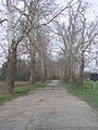
Sycamore Row is located south of the community of Deer Creek, Indiana 46917 along the west side of Indiana 29, from Deer Creek (stream), south 1,217 feet (371 m) to where it joins with Indiana 29. This is the original alignment of the w:Michigan Road.
| Camera location | | View all coordinates using: OpenStreetMap |
|---|
| Upload media | |||||
| Location |
| ||||
|---|---|---|---|---|---|
 | |||||
Media in category "Sycamore Row (Michigan Rd)"
The following 11 files are in this category, out of 11 total.
-
 Hst Marker 03-16-2018 056.jpg 3,072 × 4,608; 5.48 MB
-
 Hst Marker 03-16-2018 057.jpg 4,608 × 3,072; 4.79 MB
-
 Hst Marker 03-16-2018 059.jpg 4,608 × 3,072; 4.05 MB
-
 ROW 03-16-2018 055.jpg 3,072 × 4,608; 5.13 MB
-
 ROW 03-16-2018 058.jpg 3,072 × 4,608; 6.34 MB
-
 ROW 03-16-2018 060.jpg 3,072 × 4,608; 5.83 MB
-
 ROW 03-16-2018 061.jpg 3,072 × 4,608; 5.93 MB
-
 ROW 03-16-2018 062.jpg 4,608 × 3,072; 6.23 MB
-
 Sycamore Row (Deer Creek) P4250227.jpg 3,072 × 2,304; 1.7 MB
-
 Sycamore Row (Deer Creek) P4250228.jpg 2,304 × 3,072; 1.61 MB
-
 Sycamore Row (road).jpg 1,161 × 2,064; 1,018 KB


_P4250227.jpg)
_P4250228.jpg)
.jpg)