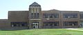
Category:Thunder Ridge Middle School (Agra, Kansas)
Jump to navigation
Jump to search
| Object location | | View all coordinates using: OpenStreetMap |
|---|
|
This is a category about a place or building that is listed on the National Register of Historic Places in the United States of America. Its reference number is 05001246. |
Listed in the National Register of Historic Places under the name "Agra Consolidated School": see "National and State Registers of Historic Places: Phillips County", at Kansas Historical Society website.
Media in category "Thunder Ridge Middle School (Agra, Kansas)"
The following 4 files are in this category, out of 4 total.
-
 Thunder Ridge Middle School 1.JPG 2,531 × 1,058; 531 KB
-
 Thunder Ridge Middle School 2.JPG 2,501 × 1,178; 607 KB
-
 Thunder Ridge Middle School 3.JPG 2,526 × 1,314; 633 KB
-
 Thunder Ridge Middle School 4.JPG 2,547 × 1,080; 475 KB


