Category:Tiree
Salti al navigilo
Salti al serĉilo
most westerly island in the Inner Hebrides of Scotland  Kvetoucí machair na pobřeží ostrova Tiree  | |||||
| Alŝuti plurmedion | |||||
| Estas | |||||
|---|---|---|---|---|---|
| Parto de | |||||
| Loko | Argyll kaj Bute, Skotlando | ||||
| Ĉe akvokorpo | |||||
| Larĝeco |
| ||||
| Longo |
| ||||
| Plej alta punkto |
| ||||
| Loĝantaro |
| ||||
| Areo |
| ||||
 | |||||
Tiree is the most westerly island in the Inner Hebrides of Scotland.
Subkategorioj
Ĉi tiu kategorio havas la 20 jenajn subkategoriojn, el 20 entute.
- Maps of Tiree (8 D)
B
- B8065 road (Scotland) (4 D)
- B8068 road (Scotland) (5 D)
- B8069 road (Scotland) (1 D)
C
- Coll and Tiree (1903) (78 D)
D
- Dun Heanish (1 D)
- Dun Hiader (5 D)
- Dun Mor a' Chaolais (6 D)
- Dun Mor Vaul (19 D)
- Dun Na Cleite (1 D)
G
K
- Kirkapol Parish Church (8 D)
N
- No. 518 Squadron RAF (3 D)
S
- Soroby Cross (3 D)
T
- Tiree Parish Church (1 D)
Dosieroj en kategorio “Tiree”
La jenaj 145 dosieroj estas en ĉi tiu kategorio, el 145 entute.
-

-
 An Dusprig - geograph.org.uk - 315926.jpg 640 × 480; 66 KB
-
 Anyone for football^ - geograph.org.uk - 865792.jpg 640 × 419; 37 KB
-
 Arriving at Tiree - geograph.org.uk - 2600528.jpg 1 600 × 1 200; 512 KB
-
 Balephuil Beach from the west - geograph.org.uk - 158467.jpg 640 × 480; 53 KB
-
 Balevullin, waves over rocks - geograph.org.uk - 4131777.jpg 640 × 481; 70 KB
-
 Beach machair boundary - geograph.org.uk - 315895.jpg 640 × 480; 63 KB
-
 Ben Hynish and Loch a'Phuill - geograph.org.uk - 1458867.jpg 640 × 480; 65 KB
-
 Big sky over the Reef - geograph.org.uk - 158457.jpg 640 × 480; 44 KB
-
 BT Tower in Scaranish - geograph.org.uk - 908827.jpg 640 × 480; 31 KB
-

-
 Ceann Mor - geograph.org.uk - 1460408.jpg 640 × 480; 50 KB
-
 Coastal Argyll , Linkspan At Scarinish, Island Of Tiree - geograph.org.uk - 4497527.jpg 1 600 × 1 200; 387 KB
-

-
 Coastline on the north side of Rubha Chraiginis - geograph.org.uk - 4480382.jpg 4 205 × 2 366; 1,78 MB
-
 Construction, Scarinish Pier - geograph.org.uk - 6357585.jpg 1 024 × 576; 183 KB
-
 Digger on the dunes - geograph.org.uk - 158479.jpg 640 × 480; 83 KB
-
 Disembarking at Tiree - geograph.org.uk - 2600538.jpg 1 600 × 1 200; 557 KB
-
 Dunes around Kilkenneth Chapel - geograph.org.uk - 315702.jpg 640 × 480; 69 KB
-
 Evening light, Traigh nan Gilean - geograph.org.uk - 4480983.jpg 4 320 × 3 240; 2,05 MB
-
 Ferry arrival, Tiree - geograph.org.uk - 7992.jpg 640 × 480; 123 KB
-
 Goose fly-past - geograph.org.uk - 4480387.jpg 4 288 × 2 567; 1,34 MB
-
 Gott Golf Club - geograph.org.uk - 1460405.jpg 640 × 480; 68 KB
-
 Gribun Hough and "the Bungalow" - geograph.org.uk - 1458863.jpg 640 × 480; 97 KB
-
 Hynish signal.jpg 422 × 596; 213 KB
-
 Icelandic horses, Tiree - geograph.org.uk - 279733.jpg 640 × 480; 107 KB
-
 Isle of Tiree Community Centre - geograph.org.uk - 1459981.jpg 640 × 480; 90 KB
-
 Isle of Tiree, April, 2017-1.jpg 4 093 × 2 728; 5,08 MB
-
 Isle of Tiree, April, 2017-10.jpg 4 726 × 3 149; 5,63 MB
-
 Isle of Tiree, April, 2017-11.jpg 4 617 × 3 076; 4,71 MB
-
 Isle of Tiree, April, 2017-12.jpg 4 855 × 3 235; 5,86 MB
-
 Isle of Tiree, April, 2017-13.jpg 4 702 × 3 132; 5,53 MB
-
 Isle of Tiree, April, 2017-14.jpg 4 633 × 3 087; 5,09 MB
-
 Isle of Tiree, April, 2017-15.jpg 4 761 × 3 172; 5,29 MB
-
 Isle of Tiree, April, 2017-20.jpg 4 783 × 3 187; 4,44 MB
-
 Isle of Tiree, April, 2017-21.jpg 4 996 × 3 329; 4,68 MB
-
 Isle of Tiree, April, 2017-22.jpg 4 811 × 3 206; 5,75 MB
-
 Isle of Tiree, April, 2017-3.jpg 4 377 × 2 916; 3,81 MB
-
 Isle of Tiree, April, 2017-5.jpg 4 915 × 3 274; 5,07 MB
-
 Isle of Tiree, April, 2017-8.jpg 4 429 × 2 951; 4,9 MB
-
 Isle of Tiree, April, 2017-9.jpg 5 030 × 3 351; 6,78 MB
-
 It's a long walk home. - geograph.org.uk - 849493.jpg 640 × 480; 47 KB
-
 Kirkapol Chapels.jpg 5 616 × 3 744; 15,32 MB
-
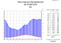 Klimadiagramm-metrisch-deutsch-Tiree (Hebriden)-GB.png 1 024 × 713; 112 KB
-
 Librig Bheag and Librig Mhòr - geograph.org.uk - 315079.jpg 640 × 480; 91 KB
-
 Little gulley leading to a pebble beach - geograph.org.uk - 316666.jpg 640 × 480; 133 KB
-
 Loch an Eilein - geograph.org.uk - 313115.jpg 640 × 480; 72 KB
-
 Loch Riaghain - geograph.org.uk - 317111.jpg 640 × 480; 51 KB
-
 Lonely tigh geal - geograph.org.uk - 316765.jpg 640 × 480; 73 KB
-
 MV Clansman tied up at Scarinish Pier, Tiree - geograph.org.uk - 5467977.jpg 768 × 1 024; 253 KB
-
 NATS road - geograph.org.uk - 865815.jpg 640 × 480; 95 KB
-
 New tower at Beinn Mhursat - geograph.org.uk - 1109105.jpg 640 × 480; 35 KB
-
 Ninth green at Tiree Golf Club - geograph.org.uk - 866812.jpg 640 × 480; 55 KB
-
 Old radar station on Beinn Hough - geograph.org.uk - 1458872.jpg 640 × 480; 98 KB
-
 Pier and link span, Scarinish - geograph.org.uk - 6357598.jpg 1 024 × 470; 120 KB
-
 Port Chunn Nèill, Isle of Tiree - geograph.org.uk - 5525457.jpg 1 024 × 576; 72 KB
-
 Port Mor - geograph.org.uk - 1458678.jpg 640 × 480; 90 KB
-
 Radar Dome, Isle of Tiree - geograph.org.uk - 89229.jpg 640 × 480; 54 KB
-
 Rinn Thorbhais - geograph.org.uk - 313593.jpg 640 × 480; 93 KB
-
 Rubha Tràigh an Dùin - geograph.org.uk - 315681.jpg 640 × 480; 89 KB
-
 Safe anchorage. - geograph.org.uk - 1469297.jpg 640 × 425; 50 KB
-
 Sand Yachting on Traigh Mhor - geograph.org.uk - 279919.jpg 640 × 336; 55 KB
-
 Sheep on the shore - geograph.org.uk - 1458294.jpg 640 × 480; 81 KB
-
 Skerries off Rubha Nead a' Gheòidh - geograph.org.uk - 315076.jpg 640 × 480; 108 KB
-
 Sloc or gully at Dunan Nighean Beveridge 1903.jpg 3 896 × 5 243; 7,71 MB
-
 So this is Tiree ^ - geograph.org.uk - 477074.jpg 640 × 436; 61 KB
-
 Standing stone near Caolas - geograph.org.uk - 317177.jpg 640 × 480; 98 KB
-
 Surprised sheep - Caora fo iongnadh - geograph.org.uk - 606148.jpg 640 × 426; 101 KB
-
 Telephone box at Kirkapol - geograph.org.uk - 1460406.jpg 640 × 480; 62 KB
-
 The view west from Cnoc an Fhithich - geograph.org.uk - 322209.jpg 640 × 480; 88 KB
-
 Tiree 'spotty' house - geograph.org.uk - 867127.jpg 640 × 480; 69 KB
-
 Tiree 2.JPG 1 600 × 1 200; 547 KB
-
 Tiree 3 P-SCO Banner.JPG 1 321 × 189; 76 KB
-
 Tiree 3.JPG 1 600 × 1 200; 657 KB
-
 Tiree Ferry Terminal - geograph.org.uk - 3243428.jpg 2 560 × 1 920; 964 KB
-
 Tiree from ferry pier - geograph.org.uk - 5465755.jpg 1 024 × 768; 220 KB
-
 Tiree Island Flag.svg 3 000 × 1 800; 114 KB
-
 Tiree ringing stone.jpg 976 × 688; 130 KB
-
 Tiree Satellite Photo.png 1 024 × 722; 744 KB
-
 Tiree, spotted house.jpg 601 × 380; 55 KB
-
 Track to Gott - geograph.org.uk - 313925.jpg 640 × 480; 109 KB
-
 Track to Traigh Ghrianal - geograph.org.uk - 1458846.jpg 640 × 480; 82 KB
-
 Traidh Thodhrasdail, Tiree - geograph.org.uk - 786613.jpg 479 × 640; 35 KB
-
 Traigh Ghrianal - geograph.org.uk - 866098.jpg 640 × 480; 113 KB
-
 Traigh Thodrasdail - geograph.org.uk - 1458697.jpg 640 × 480; 52 KB
-
 Tràigh Bhì - geograph.org.uk - 599979.jpg 640 × 426; 52 KB
-
 Tur Mhiccalium - geograph.org.uk - 902989.jpg 563 × 446; 83 KB
-
 Unloading at Tiree - geograph.org.uk - 2600532.jpg 1 600 × 1 200; 652 KB
-
 VarickEastonTiree.jpg 572 × 389; 47 KB
-
 Washed ashore - geograph.org.uk - 323446.jpg 640 × 480; 96 KB
-
 Western end of Traigh Ghrianal - geograph.org.uk - 1458690.jpg 640 × 480; 86 KB
-
 WWII remains near Barrapol - geograph.org.uk - 13674.jpg 640 × 467; 82 KB
-
 Across the moorland to Gott Hill - geograph.org.uk - 313699.jpg 640 × 480; 67 KB
-
 Allt Ban as it reaches the sea - geograph.org.uk - 316636.jpg 640 × 480; 86 KB
-
 An Cnap - geograph.org.uk - 313883.jpg 640 × 480; 96 KB
-
 An Dusprig - geograph.org.uk - 315923.jpg 640 × 480; 73 KB
-
 An Fhaodhail - geograph.org.uk - 315928.jpg 640 × 480; 58 KB
-
 An Fhaodhail as it reaches the sea - geograph.org.uk - 312318.jpg 640 × 480; 98 KB
-
 Bay at Vaul - geograph.org.uk - 1460303.jpg 640 × 480; 79 KB
-
 Beinn Ghott - geograph.org.uk - 1460286.jpg 640 × 480; 95 KB
-
 Carsamull - geograph.org.uk - 320502.jpg 640 × 480; 80 KB
-
 Cattle grid on the B8068 - geograph.org.uk - 1460281.jpg 640 × 480; 73 KB
-
 Causeway to Rubha Liath - geograph.org.uk - 1461341.jpg 640 × 480; 103 KB
-
 Ceann Mòr and Sgeir na Fàinne - geograph.org.uk - 313868.jpg 640 × 480; 107 KB
-
 Crags at Vaul - geograph.org.uk - 316784.jpg 640 × 480; 114 KB
-
 Creagan Mòra - geograph.org.uk - 313907.jpg 640 × 480; 89 KB
-
 Crossapol Burn - geograph.org.uk - 323426.jpg 640 × 480; 82 KB
-
 Cup marks on the ringing stone - geograph.org.uk - 317105.jpg 640 × 480; 124 KB
-
 Dental surgery on Tiree - geograph.org.uk - 323432.jpg 640 × 480; 58 KB
-
 End of the road - geograph.org.uk - 312842.jpg 640 × 480; 92 KB
-
 Filling station and garage - geograph.org.uk - 317240.jpg 640 × 480; 59 KB
-
 Fàdamull - geograph.org.uk - 317159.jpg 640 × 480; 70 KB
-

-

-

-
 Line in the sand - geograph.org.uk - 312656.jpg 640 × 480; 122 KB
-
 Loch Riaghain - geograph.org.uk - 317113.jpg 640 × 480; 72 KB
-
 Machair above Traigh Bhagh - geograph.org.uk - 312303.jpg 640 × 480; 91 KB
-
 Moorland near Gott - geograph.org.uk - 315094.jpg 640 × 480; 91 KB
-

-
 Old CEL Roller at West Hynish - geograph.org.uk - 158495.jpg 640 × 480; 124 KB
-

-
 Pier to Fàdamull^ - geograph.org.uk - 314062.jpg 640 × 480; 99 KB
-
 Port Mòr - geograph.org.uk - 316109.jpg 640 × 480; 70 KB
-
 Rainbow over Salum Bay - geograph.org.uk - 313863.jpg 640 × 480; 53 KB
-
 Reflections on Tràigh Mhòr - geograph.org.uk - 313771.jpg 640 × 480; 43 KB
-
 Reflections on Tràigh Mhòr - geograph.org.uk - 320488.jpg 640 × 480; 38 KB
-
 Ringing Stone or Clach a' Choire - geograph.org.uk - 317098.jpg 640 × 480; 85 KB
-
 Rubh a' Phuirt Bhig - geograph.org.uk - 313836.jpg 640 × 480; 52 KB
-
 Ruined wall - geograph.org.uk - 315677.jpg 640 × 480; 63 KB
-
 Silage and grazing sheep - geograph.org.uk - 317277.jpg 640 × 480; 73 KB
-
 Silversands - geograph.org.uk - 316747.jpg 640 × 480; 63 KB
-
 Skerries in Salum Bay - geograph.org.uk - 317164.jpg 640 × 480; 63 KB
-
 Small beach near Am Beannan Ruadh - geograph.org.uk - 313901.jpg 640 × 480; 92 KB
-
 Southern end of An Traigh-lochainn - geograph.org.uk - 314037.jpg 640 × 480; 81 KB
-
 The mouth of An Fhodhail - geograph.org.uk - 315915.jpg 640 × 480; 104 KB
-
 The old and the new - geograph.org.uk - 279913.jpg 640 × 360; 70 KB
-
 Tiree north coast - geograph.org.uk - 317092.jpg 640 × 480; 110 KB
-
 Track across the machair - geograph.org.uk - 313858.jpg 640 × 480; 72 KB
-
 Track under water - geograph.org.uk - 313944.jpg 640 × 480; 105 KB
-
 Tràigh Mhòr - geograph.org.uk - 313714.jpg 640 × 480; 50 KB
-
 Typical Architecture on Tiree - geograph.org.uk - 279910.jpg 640 × 360; 67 KB
-
 Very wet moorland - geograph.org.uk - 315667.jpg 640 × 480; 89 KB
-
 View from Rubh a' Phuirt Bhig - geograph.org.uk - 313820.jpg 640 × 480; 66 KB
-
 View to Beinn Gott - geograph.org.uk - 317284.jpg 640 × 480; 113 KB


-GB.png)


_-_geograph.org.uk_-_89487.jpg)


