Category:Tower of Brama Żarska
Jump to navigation
Jump to search
| Camera location | | View all coordinates using: OpenStreetMap |
|---|
 | |||||
| Upload media | |||||
| Instance of | |||||
|---|---|---|---|---|---|
| Location | Trzebiel, Gmina Trzebiel, Żary County, Lubusz Voivodeship, Poland | ||||
| Street address |
| ||||
| Heritage designation |
| ||||
| Inception |
| ||||
 | |||||
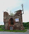
Polski: ruina baszty przy dawnej Bramie Żarskiej w Trzebielu z połowy XIV w.
Deutsch: Ruine des Turms des Sorauer Tores der früheren Stadtmauer in Trzebiel (Triebel), Woiwodschaft Lebus, Mitte 14. Jahrhundert
Media in category "Tower of Brama Żarska"
The following 4 files are in this category, out of 4 total.
-
 PL Trzebiel tower 1.jpg 3,456 × 3,456; 7.84 MB
-
 PL Trzebiel tower 2.jpg 3,431 × 3,431; 8.01 MB
-
 Trzebiel Baszta Mury Obronne 01.jpg 4,128 × 3,648; 9.34 MB
-
 Trzebiel Baszta Mury Obronne 02.jpg 3,392 × 4,048; 7.48 MB


