Category:Trifthütte
Jump to navigation
Jump to search
| Object location | | View all coordinates using: OpenStreetMap |
|---|
 | |||||
| Upload media | |||||
| Instance of | |||||
|---|---|---|---|---|---|
| Location | Gadmen, Innertkirchen, Interlaken-Oberhasli administrative district, Oberland administrative region, Bern, Switzerland | ||||
| Street address |
| ||||
| Owned by |
| ||||
| Inception |
| ||||
| Mountain range | |||||
| Elevation above sea level |
| ||||
 | |||||
Media in category "Trifthütte"
This category contains only the following file.
-
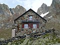 Trifthütte 2520m, Sektion Bern SAC.JPG 4,320 × 3,240; 5.89 MB