Category:Tuolumne River
Vai alla navigazione
Vai alla ricerca
watercourse in the United States of America  | |||||
| Carica un file multimediale | |||||
| Istanza di | |||||
|---|---|---|---|---|---|
| Area protetta | |||||
| Luogo | California, Stati del Pacifico | ||||
| Lunghezza |
| ||||
| Foce | |||||
| Bacino di drenaggio |
| ||||
| Nazione rivierasca | |||||
| Affluente |
| ||||
 | |||||
English: The Tuolumne River is a major river of the Sierra Nevada, flowing from Yosemite National Park to the San Joaquin Valley in California. The Tuolumne is a tributary of the San Joaquin River.
Sottocategorie
Questa categoria contiene le 10 sottocategorie indicate di seguito, su un totale di 10.
B
C
- Cherry Lake, California (14 F)
G
- Grand Canyon of the Tuolumne (16 F)
H
L
- Lyell Fork of the Tuolumne River (15 F)
P
- Pine Mountain Lake (2 F)
R
- Rapids of the Tuolumne River (3 F)
S
T
Pagine nella categoria "Tuolumne River"
Questa categoria contiene un'unica pagina, indicata di seguito.
File nella categoria "Tuolumne River"
Questa categoria contiene 35 file, indicati di seguito, su un totale di 35.
-
 117.TuolumneRiver.JPG 4 000 × 3 000; 3,45 MB
-
 123.TuolumneRiver.JPG 4 524 × 2 902; 4,37 MB
-

-
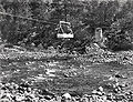
 47. River mining on the Tuolumne.jpg 1 000 × 709; 320 KB
-
 California - Modesto - NARA - 23934545.jpg 1 984 × 1 584; 834 KB
-
 California Falls, Tuolumne River, California (1921).jpg 1 968 × 1 147; 1,34 MB
-
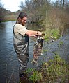
 Chinook salmon moving upstream.jpg 3 504 × 2 336; 2,54 MB
-
 Creekside Path with Snow, Yosemite NP 5-20-15 (17511212404).jpg 2 800 × 2 100; 3,51 MB
-
 Dawn on Tuolumne River, Yosemite 5-29-15 (18291134816).jpg 2 800 × 2 279; 3,6 MB
-

-

-
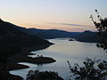
 La Grange Reservoir from the top of the New Don Pedro Dam.jpg 6 000 × 4 000; 15,4 MB
-
 Lembert Dome and Tuolumne River from Parsons Lodge bridge - panoramio.jpg 1 024 × 768; 171 KB
-

-
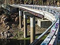
 Lumsden Bridge over the Tuolumne River (8414759080).jpg 3 888 × 2 592; 5,68 MB
-
 Tuolumne River (5931918584).jpg 1 764 × 1 309; 686 KB
-
 Tuolumne River (8411075439).jpg 3 072 × 2 304; 7 MB
-
 Tuolumne River and Clavey River and Sourth Fork aerial from above Buck Meadows.jpg 3 762 × 2 975; 6,18 MB
-
 Tuolumne River Modesto.jpg 800 × 456; 145 KB
-
 Tuolumne River near Wards Ferry.jpg 5 261 × 3 946; 13,81 MB
-
 Tuolumne River San Joaquin River Confluence.jpg 6 000 × 4 000; 14,75 MB
-
 Tuolumne river-south fork 1.jpeg 1 600 × 1 200; 353 KB
-
 Tuolumne river-south fork 2.jpeg 1 200 × 1 600; 322 KB
-
 Tuolumne river-south fork 4.jpeg 1 200 × 1 600; 157 KB
-
 Tuolumne river-south fork 5.jpeg 1 200 × 1 600; 311 KB
-
 Tuolumne River.PNG 800 × 456; 704 KB
-
 Tuolumne Snorkel Survey-Adult Mortatlity (16231741641).jpg 2 801 × 3 388; 6,43 MB
-
 Tuolumne Snorkel Survey-Almost Ready (16207703776).jpg 2 593 × 3 645; 7,97 MB
-
 Tuolumne Snorkel SurveySnorkeling (16233598335).jpg 2 400 × 2 747; 4,49 MB
-
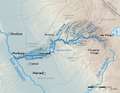 Tuolumnemap-01.png 1 875 × 1 458; 760 KB
-
 TuolumneMeadowsFromWest.jpg 3 868 × 2 730; 5,55 MB
-
 TuolumneRiver (19099383301).jpg 1 430 × 804; 929 KB
-
 TuolumneRiverBeloveDam.jpg 4 188 × 3 210; 11,06 MB
-
 Tuolumnerivermap.jpg 754 × 573; 206 KB
-
 Wards Ferry Bridge 2016.jpg 5 333 × 4 000; 15,43 MB


.jpg)

.jpg)
.jpg)

.jpg)


.jpg)
.jpg)
.jpg)


.jpg)
.jpg)
.jpg)


.jpg)


Categorie:
- Rivers of California
- Rivers of the Sierra Nevada (USA)
- Tributaries of the San Joaquin River
- Geography of Mariposa County, California
- Geography of Stanislaus County, California
- Geography of Tuolumne County, California
- Stanislaus National Forest
- San Joaquin Valley
- Biosphere reserves in the United States
- Rivers of the United States by name
- Visitor attractions in Tuolumne County, California