Category:Twelve Bens
Vai alla navigazione
Vai alla ricerca
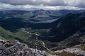
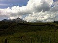
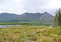
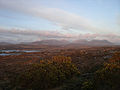
Twelve Bens, a mountain range in Connemara in Ireland
mountain range in Galway, Ireland  | |||||
| Carica un file multimediale | |||||
| Istanza di | |||||
|---|---|---|---|---|---|
| Luogo | contea di Galway, Connacht, Irlanda | ||||
| Punto più alto | |||||
| Altezza sul mare |
| ||||
 | |||||
Sottocategorie
Questa categoria contiene le 18 sottocategorie indicate di seguito, su un totale di 18.
B
- Benbaun (25 F)
- Benbaun (477 m) (13 F)
- Benbrack (13 F)
- Benbreen (14 F)
- Bencollaghduff (21 F)
- Bencorr (31 F)
- Bencullagh (6 F)
- Benfree (11 F)
- Benglenisky (5 F)
- Bengower (15 F)
- Benlettery (12 F)
D
- Derryclare (34 F)
- Derryclare Lough (11 F)
- Diamond Hill (Ireland) (38 F)
G
- Garraun (19 F)
L
- Lough Inagh (47 F)
M
- Muckanaght (11 F)
T
- Tully Mountain (4 F)
File nella categoria "Twelve Bens"
Questa categoria contiene 79 file, indicati di seguito, su un totale di 79.
-
 12 Bens and Bog (6047392519).jpg 3 456 × 2 592; 2,05 MB
-
 12 Bens from the Bog Road (6047392739).jpg 2 592 × 1 936; 1,51 MB
-
 2016-08-08-Clifden-6824.jpg 5 747 × 3 831; 15,77 MB
-
 2016-08-09-Panorama 12 Bens -.jpg 11 476 × 3 684; 27,75 MB
-
 Access road to the mast on An Chreig - geograph.org.uk - 5010200.jpg 1 024 × 682; 185 KB
-
 An Chreig, the northwest slopes - geograph.org.uk - 5010195.jpg 1 024 × 672; 184 KB
-
 Benbaun, Twelve Pins, Connemara - geograph.org.uk - 148022.jpg 640 × 420; 49 KB
-
 Benbreen viewed from Benbaun summit.jpg 5 184 × 3 456; 7,12 MB
-
 Bencorr, Bencollaghduff & Derryclare from south ridge of Benbaun.jpg 898 × 600; 83 KB
-
 Bencullagh, Muckanaght & Benfree from Benbaun II.jpg 898 × 600; 89 KB
-
 Bengower, Benbreen, Benbaun & Bencollaghduff from Derryclare.jpg 898 × 600; 92 KB
-
 Big clouds (6047971686).jpg 2 592 × 1 936; 619 KB
-
 Boats & sky, Roundstone (6047412955).jpg 2 592 × 1 936; 685 KB
-
 Boats and mountains, Roundstone (6047965086).jpg 3 456 × 2 592; 893 KB
-
 Bog & Bens (6047964728).jpg 2 592 × 1 936; 786 KB
-
 Caher black head.jpg 3 040 × 2 024; 1,07 MB
-
 Connemara, The Twelve Bens (or Pins) - geograph.org.uk - 65979.jpg 640 × 422; 92 KB
-
 Connemara12Bens.jpg 2 272 × 1 704; 2,66 MB
-
 Derryclare Lake, Connemara.jpg 4 032 × 2 502; 3,12 MB
-
 Derryclare Lough - geograph.org.uk - 540873.jpg 640 × 396; 54 KB
-
 Derryclare Lough, Twelve Bens.jpg 7 000 × 3 938; 14,06 MB
-

-
 Derrywaking, Connemara. - geograph.org.uk - 71321.jpg 640 × 430; 115 KB
-
 Errisbeg and the Twelve Pins - geograph.org.uk - 377507.jpg 575 × 383; 79 KB
-

-
 Franciscan Friary, Roundstone.jpg 2 000 × 1 960; 1,65 MB
-
 Glencoaghan Horseshoe, Twelve Bens, Ireland.jpg 4 704 × 3 136; 5,75 MB
-
 Glencoaghan Horseshoe, Twelve Bens.jpg 4 032 × 3 024; 5,7 MB
-
Glencoaghan Horseshoe.webm 7,0 s, 1 280 × 720; 1,1 MB
-
 Hawthorn tree below Ben Lettery, Connemara, Co. Galway.jpg 4 032 × 2 560; 2,52 MB
-
 Illanballa island, Killary Harbour - geograph.org.uk - 201093.jpg 640 × 490; 131 KB
-
 Leenane banner.jpg 2 642 × 378; 362 KB
-

-
 Looking towards the barren landscape of the Twelve Bens, Connemara National park.jpg 3 888 × 2 592; 3,89 MB
-
 Lough Inagh, with Twelve Bens behind - geograph.org.uk - 199754.jpg 640 × 443; 130 KB
-
 Maumturk Mountains 002.jpg 4 873 × 3 249; 9,22 MB
-
 Maumturk Mountains 02.jpg 5 184 × 3 456; 12,83 MB
-
 Maumturk Mountains 03.jpg 5 184 × 3 456; 14,26 MB
-
 Maumturk Mountains 05.jpg 4 873 × 3 249; 9,21 MB
-
 North view of the 12 Bens at sunset.jpg 1 024 × 768; 465 KB
-
 Ordnance Survey Half-Inch Sheet 10 Clifden, Published 1968.jpg 8 231 × 11 330; 9,75 MB
-
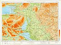 Ordnance Survey Ireland Half-Inch Sheet 11 South Mayo, Published 1965.jpg 11 912 × 8 696; 13,22 MB
-
 Owengin and Twelve Bens - geograph.org.uk - 200344.jpg 515 × 640; 138 KB
-
 Owengin pool - geograph.org.uk - 200349.jpg 530 × 640; 145 KB
-
 Owengin River and Twelve Bens - geograph.org.uk - 200205.jpg 640 × 505; 156 KB
-
 Owengin River with Twelve Bens behind - geograph.org.uk - 200147.jpg 640 × 473; 153 KB
-

-
 Peat cutting by the Twelve Bens - geograph.org.uk - 199809.jpg 640 × 450; 138 KB
-
 Polladirk river and Twelve Bens.JPG 2 048 × 1 536; 730 KB
-
 Polladirk Valley, Twelve Bens, Ireland.jpg 5 000 × 3 333; 10,73 MB
-
 Riding up from Rossaveal (6042540241).jpg 3 456 × 2 592; 1,77 MB
-
 Roundstone (6047999680).jpg 2 592 × 1 936; 761 KB
-
 Stream and 12 Bens (6047448819).jpg 2 592 × 1 936; 747 KB
-

-
 The Twelve Bens - geograph.org.uk - 539092.jpg 640 × 281; 46 KB
-
 The Twelve Bens 001.jpg 5 184 × 3 456; 13,21 MB
-
 The Twelve Bens 002.jpg 5 184 × 3 456; 9,36 MB
-
 Turbary cutting (for removing peat) - geograph.org.uk - 65980.jpg 640 × 432; 107 KB
-
 Twelve Bens across Lough Inagh.jpg 4 032 × 3 024; 5,54 MB
-
 Twelve Bens Connemara 1950s.jpg 4 093 × 3 131; 2,15 MB
-
 Twelve Bens from Cleggan Lake (3585934316).jpg 4 526 × 2 284; 2,37 MB
-
 Twelve Bens from Cleggan Lake 01 (3585929926).jpg 2 560 × 1 920; 461 KB
-
 Twelve Bens from Cleggan Lake HDR01 (3585930796).jpg 2 560 × 1 920; 493 KB
-
 Twelve Bens from Lough Inagh.jpg 1 462 × 626; 427 KB
-
 Twelve Bens Horseshoe.jpg 4 018 × 2 425; 3,21 MB
-
 Twelve Bens II, Connemara, Ireland.jpg 5 312 × 2 988; 2,62 MB
-
 Twelve Bens viewed from Diamond Hill.jpg 5 184 × 3 456; 5,18 MB
-
 Twelve Bens, Connemara, Ireland.jpg 4 032 × 3 024; 4,98 MB
-
 Twelve Bens.jpg 2 642 × 800; 533 KB
-
 Twelve Bins (2409309593).jpg 3 888 × 2 592; 2,89 MB
-
 Twelve pins.jpg 700 × 467; 97 KB
-
 Twelve-bens.jpg 640 × 465; 43 KB
-
 Twilight TwelveBens.jpg 842 × 520; 70 KB
-

-
-

-

-
 Waterweed in the Owengin - geograph.org.uk - 200211.jpg 502 × 640; 156 KB
-

.jpg)
.jpg)


.jpg)
.jpg)
.jpg)
.jpg)

_-_geograph.org.uk_-_65979.jpg)


.jpg)
.jpg)
.jpg)


_-_geograph.org.uk_-_65980.jpg)


.jpg)
.jpg)
.jpg)


.jpg)


