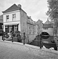
Category:Uilenburg Brug tussen 10 en 13 ('s-Hertogenbosch)
Jump to navigation
Jump to search
| Object location | | View all coordinates using: OpenStreetMap |
|---|
bridge in Netherlands  | |||||
| Upload media | |||||
| Instance of | |||||
|---|---|---|---|---|---|
| Location | 's-Hertogenbosch, North Brabant, Netherlands | ||||
| Street address |
| ||||
| Heritage designation |
| ||||
 | |||||
|
This is a category about rijksmonument number 21948
|
| Address |
|
Media in category "Uilenburg Brug tussen 10 en 13 ('s-Hertogenbosch)"
The following 2 files are in this category, out of 2 total.
-
 's-Hertogenbosch Rijksmonument 21948 Uilenburg brug tussen 10 en 13.JPG 3,648 × 2,736; 3.6 MB
-