Category:Untere Hauptstraße 1 Retzbach
Jump to navigation
Jump to search
| Object location | | View all coordinates using: OpenStreetMap |
|---|
This is the category of the Bavarian Baudenkmal (cultural heritage monument) with the ID D-6-77-203-110 (Wikidata)
|
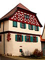
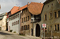
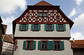
Deutsch: Bauernhof. Wohnhaus, zweigeschossiger Halbwalmdachbau über hohem Kellerhanggeschoss mit vorkragendem verputztem Fachwerkobergeschoss und Zierfachwerkgiebel in Ecklage, 17./18. Jahrhundert.
Untere Hauptstraße 1, Retzbach (Zellingen), Landkreis Main-Spessart, Unterfranken, Bayern, Deutschland
Untere Hauptstraße 1, Retzbach (Zellingen), Landkreis Main-Spessart, Unterfranken, Bayern, Deutschland
cultural heritage monument D-6-77-203-110 (0) in Zellingen, Bavaria .JPG) | |||||
| Upload media | |||||
| Instance of | |||||
|---|---|---|---|---|---|
| Location | Zellingen, Main-Spessart, Lower Franconia, Bavaria, Germany | ||||
| Street address |
| ||||
| Heritage designation | |||||
 | |||||
Media in category "Untere Hauptstraße 1 Retzbach"
The following 7 files are in this category, out of 7 total.
-
 Untere Hauptstraße 1 (Retzbach).JPG 1,728 × 2,304; 1.42 MB
-
 Zellingen, Markt Retzbach, Untere Hauptstraße 1, 3, 5-001.jpg 4,928 × 3,264; 8.54 MB
-
 Zellingen, Markt Retzbach, Untere Hauptstraße 1-001.jpg 3,264 × 4,928; 6.25 MB
-
 Zellingen, Markt Retzbach, Untere Hauptstraße 1-002.jpg 4,928 × 3,264; 5.62 MB
-
 Zellingen, Markt Retzbach, Untere Hauptstraße 1-003.jpg 4,928 × 3,264; 5.6 MB
-
 Zellingen, Markt Retzbach, Untere Hauptstraße 1-004.jpg 4,928 × 3,264; 8.18 MB
-
 Zellingen, Markt Retzbach, Untere Hauptstraße 1-005.jpg 3,264 × 4,928; 9.36 MB


