Category:Utah Valley
Zur Navigation springen
Zur Suche springen
valley in Utah County, Utah, United States  | |||||
| Medium hochladen | |||||
| Ist ein(e) | |||||
|---|---|---|---|---|---|
| Ist Teil von | |||||
| Ort | Utah County, Utah | ||||
| Liegt am oder im Gewässer | |||||
| Gebirgszug | |||||
 | |||||
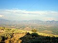
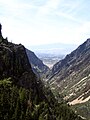
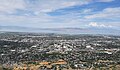
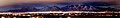
English: Media related to the Utah Valley, a valley within Utah County, Utah, United States, which entirely surrounds Utah Lake.
Unterkategorien
Es werden 33 von insgesamt 33 Unterkategorien in dieser Kategorie angezeigt:
In Klammern die Anzahl der enthaltenen Kategorien (K), Seiten (S), Dateien (D)
A
- American Fork (river) (12 D)
B
- Buckley Mountain (Utah) (61 D)
C
- Corral Mountain (Utah) (33 D)
D
- Dominguez Hill (2 D)
- Dry Mountain (Utah County, Utah) (16 D)
E
- Ether Peak (14 D)
G
H
J
K
- Kyhv Peak (28 D)
L
- Loafer Mountain (19 D)
M
- Mapleton Lateral (6 D)
- Mill Race Canal (1 D)
P
- Powerhouse Mountain (21 D)
S
- Salem Lake (Utah) (9 D)
- Santaquin Peak (25 D)
- Spanish Oaks Reservoir (6 D)
- Strawberry Highline Canal (Utah) (11 D)
T
U
W
Medien in der Kategorie „Utah Valley“
Folgende 40 Dateien sind in dieser Kategorie, von 40 insgesamt.
-

-

-
 Bird3.JPG 3.072 × 2.304; 2,73 MB
-
 Down lower Maple Canyon, Utah County, Utah, Jul 16.jpg 2.592 × 1.944; 2,39 MB
-
 Down upper Maple Canyon, Utah County, Utah, Jul 16.jpg 2.592 × 1.944; 2,29 MB
-
 Finish Line Utah Valley Marathon 2021.jpg 4.032 × 3.024; 4,29 MB
-

-
 Looking down on central Springville, Jun 04.jpg 1.280 × 960; 305 KB
-
 Looking down on east Mapleton, Utah, Jun 04.jpg 1.280 × 960; 313 KB
-
 Looking down on east Springville, Jun 04.jpg 1.280 × 960; 307 KB
-
 Looking down on north Springville, Jun 04.jpg 1.280 × 960; 306 KB
-
 Looking down on Utah Lake, Jun 04.jpg 1.280 × 960; 307 KB
-

-
 Mountain Views.jpg 4.128 × 2.322; 2,71 MB
-
 Mountains in Utah Valley.jpg 4.032 × 3.024; 2,38 MB
-
 Mountains in Utah.jpg 4.032 × 3.024; 2,12 MB
-
 Nebo and Utah Lake - panoramio.jpg 2.160 × 1.440; 573 KB
-
 Northeast across Utah Valley from West Mountain, Utah, Jun 16.jpg 2.592 × 1.944; 2,23 MB
-
 Northern Utah Valley from the air (1).jpg 4.000 × 3.000; 2,67 MB
-
 Provo Valley, Utah (NYPL b12647398-70460).tiff 2.448 × 1.678; 11,76 MB
-
 Provo utah 2009.jpg 1.000 × 750; 122 KB
-
 Redwood Rd descending into Utah County.jpg 3.264 × 2.448; 1,91 MB
-
 Salt Lake Valley.png 1.024 × 1.024; 1.014 KB
-
 SLCfromLakeMountain.jpg 3.072 × 2.304; 1,37 MB
-
 South Provo from the Y, May 2008.JPG 2.816 × 2.112; 2,55 MB
-
 Southern Utah Valley, Feb 08 - panoramio.jpg 2.500 × 1.277; 743 KB
-
 Utah (2808008898).jpg 3.872 × 2.592; 4,52 MB
-
 Utah Lake and northwest Utah Valley, Mar 10.jpg 4.000 × 3.000; 2,71 MB
-
 Utah Lake prove map.jpg 580 × 853; 99 KB
-
 Utah Lake satellite view.JPG 639 × 423; 168 KB
-
 Utah Valley (from Spanish Oaks Reservoir), May 2017.jpg 2.592 × 1.944; 2,42 MB
-
 Utah Valley Banner.jpg 2.800 × 400; 457 KB
-
 UtahValleyfromLM.jpg 5.056 × 1.344; 1,52 MB
-
 UtahvalleyfromWM.jpg 1.600 × 1.200; 425 KB
-
 Valley at Timpanogos Cave.jpg 1.536 × 2.048; 1,48 MB
-
 View From Grove Creek Trail in September - panoramio.jpg 2.800 × 2.128; 1,76 MB
-
 View from the top of Mount Timpanogos.jpg 1.296 × 968; 77 KB
-
 View of Lake Mountains over Utah Valley, Feb 17.jpg 2.592 × 1.944; 2,35 MB
-
 View of Utah Valley.jpg 4.032 × 2.349; 2,23 MB
-
 Лон Пик Панорама.jpg 11.300 × 1.656; 1,65 MB


.jpg)


.jpg)


.jpg)


,_May_2017.jpg)


Kategorien:
- Valleys of Utah
- Landforms of Utah County, Utah
- Valleys of the Great Basin in Utah
- Wasatch Front
- Locations along Interstate 15 in Utah County, Utah
- Locations along U.S. Route 6 in Utah County, Utah
- Locations along U.S. Route 50 in Utah (1926-1953) in Utah County, Utah
- Locations along U.S. Route 50 Alternate in Utah County, Utah
- Locations along U.S. Route 89 in Utah County, Utah
- Locations along U.S. Route 91 in Utah (1926-1974) in Utah County, Utah
- Locations along U.S. Route 189 in Utah County, Utah
- Locations along Utah State Route 26 (1910-1969) in Utah County, Utah
- Locations along Utah State Route 27 (1927-1977) in Utah County, Utah
- Locations along Utah State Route 68 in Utah County, Utah
- Locations along Utah State Route 73 in Utah County, Utah