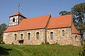
Category:Village Church (Gielsdorf)
Jump to navigation
Jump to search
| Object location | | View all coordinates using: OpenStreetMap |
|---|
church building in Brandenburg state, Germany  | |||||
| Upload media | |||||
| Instance of | |||||
|---|---|---|---|---|---|
| Location | Gielsdorf, Altlandsberg, Märkisch-Oderland District, Brandenburg, Germany | ||||
| Heritage designation | |||||
 | |||||
English: Pictures of the church in Gielsdorf , Altlandsberg municipality, Märkisch-Oderland district, Brandenburg state, Germany
Deutsch: Bilder der Kirche in Gielsdorf , Stadt Altlandsberg, Landkreis Märkisch-Oderland, Land Brandenburg, Deutschland.
Français : Photos de l'église à Gielsdorf , ville de Altlandsberg, arrondissement de Märkisch-Oderland, état fédéral de Brandebourg, Allemagne
This is the category of the Brandenburger Baudenkmal (cultural heritage monument) with the ID 09180446 (Wikidata)
|
Media in category "Village Church (Gielsdorf)"
The following 13 files are in this category, out of 13 total.
-
 Dorfkirche Gielsdorf Nordansicht Chor.jpg 3,024 × 4,032; 2.97 MB
-
 Dorfkirche Gielsdorf Nordansicht Kirchenschiff Grabstein Pfuel.jpg 4,032 × 3,024; 4.97 MB
-
 Dorfkirche Gielsdorf Nordansicht Kirchenschiff.jpg 4,032 × 3,024; 2.99 MB
-
 Dorfkirche Gielsdorf Ostansicht.jpg 3,024 × 4,032; 2.38 MB
-
 Dorfkirche Gielsdorf Südansicht Chor.jpg 3,024 × 4,032; 4.58 MB
-
 Dorfkirche Gielsdorf Südansicht Kirchenschiff.jpg 4,032 × 3,024; 4.77 MB
-
 Dorfkirche Gielsdorf Südostansicht.jpg 4,032 × 3,024; 4.05 MB
-
 Dorfkirche Gielsdorf Westansicht.jpg 3,024 × 4,032; 3.5 MB
-
 Dorfkirche Gielsdorf Westturm Südansicht.jpg 3,024 × 4,032; 4.11 MB
-
 Dorfkirche Gielsdorf.jpg 3,264 × 1,836; 2.56 MB
-
 Gielsdorf church.jpg 1,920 × 1,260; 439 KB
-
 Gielsdorf Kirche.jpg 1,633 × 1,345; 563 KB
-
 Kirche Gielsdorf Altlandsberg.jpg 6,016 × 4,000; 3.08 MB


