Category:Village Church (Podelzig)
Jump to navigation
Jump to search
| Object location | | View all coordinates using: OpenStreetMap |
|---|
 | |||||
| Upload media | |||||
| Instance of | |||||
|---|---|---|---|---|---|
| Location | Podelzig, Märkisch-Oderland District, Brandenburg, Germany | ||||
| Heritage designation | |||||
 | |||||
This is the category of the Brandenburger Baudenkmal (cultural heritage monument) with the ID 09180816 (Wikidata)
|
Deutsch: Bilder der Kirche in Podelzig, Gemeinde Podelzig, Landkreis Märkisch-Oderland, Land Brandenburg, Deutschland.
English: Pictures of the church in Podelzig, Podelzig municipality, Märkisch-Oderland district, Brandenburg state, Germany
Français : Photos de l'église à Podelzig, commune de Podelzig, arrondissement de Märkisch-Oderland, état fédéral de Brandebourg, Allemagne
Media in category "Village Church (Podelzig)"
The following 11 files are in this category, out of 11 total.
-
 Alt-Podelzig Inneres der Kirche Blick nach Osten Lebus Tafel 28.jpg 4,194 × 6,271; 13.71 MB
-
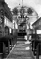 Alt-Podelzig Inneres der Kirche Blick nach Osten.jpg 3,206 × 4,623; 5.62 MB
-

-
 Kirchenruine Podelzig 1.JPG 3,072 × 4,608; 7.77 MB
-
 Kirchenruine Podelzig 3.JPG 3,072 × 4,608; 7.41 MB
-
 Kirchenruine Podelzig 4.JPG 4,608 × 3,072; 7.77 MB
-
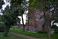 Kirchenruine Podelzig 5.JPG 4,608 × 3,072; 7.31 MB
-
 Kirchenruine Podelzig 6.JPG 3,072 × 4,608; 5.98 MB
-
 Kirchenruine Podelzig 7.JPG 3,072 × 4,608; 5.83 MB
-
 Podelzig - Ruine der Dorfkirche - panoramio.jpg 600 × 450; 68 KB
-
 Podelzig Kirche.jpg 3,872 × 2,592; 1.96 MB


