Category:Voormalige Willibrorduskerk (Geijsteren)
Jump to navigation
Jump to search
| Object location | | View all coordinates using: OpenStreetMap |
|---|
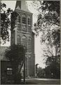
Nederlands: Geijsteren, Dorpstraat 18 - Willibrorduskerk (1865 - 1944) - Deze kerk is door oorlogsgeweld in 1944 vernield
Media in category "Voormalige Willibrorduskerk (Geijsteren)"
The following 58 files are in this category, out of 58 total.
-
 Beeld van de H.Augustinus - Geysteren - 20077873 - RCE.jpg 839 × 1,200; 150 KB
-
 Beeld van de H.Willebrordus - Geysteren - 20077874 - RCE.jpg 857 × 1,200; 180 KB
-
 Beeld van Joh.de Dooper - Geysteren - 20077872 - RCE.jpg 855 × 1,200; 138 KB
-
 Bovenste deel toren - Geysteren - 20326406 - RCE.jpg 866 × 1,200; 266 KB
-
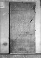
 Grafsteen in het portaal - Geysteren - 20077854 - RCE.jpg 1,200 × 896; 356 KB
-
 Grafzerk - Geysteren - 20077855 - RCE.jpg 852 × 1,200; 195 KB
-
 Grafzerk - Geysteren - 20077860 - RCE.jpg 848 × 1,200; 203 KB
-
 Grafzerk in de toren - Geysteren - 20077859 - RCE.jpg 921 × 1,200; 191 KB
-
 Grafzerk in west muur - Geysteren - 20077858 - RCE.jpg 864 × 1,200; 212 KB
-
 Grafzerk onder de toren - Geysteren - 20077856 - RCE.jpg 847 × 1,200; 237 KB
-
 Grijs marmeren doopvont - Geysteren - 20077862 - RCE.jpg 855 × 1,200; 135 KB
-
 Ingang - Geysteren - 20326399 - RCE.jpg 911 × 1,200; 223 KB
-
 Interieur - Geysteren - 20077853 - RCE.jpg 935 × 1,200; 183 KB
-
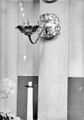 Koperen armluchter - Geysteren - 20077870 - RCE.jpg 839 × 1,200; 104 KB
-
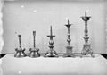 Koperen kandelaars - Geysteren - 20077868 - RCE.jpg 1,200 × 842; 133 KB
-
 Koperen kandelaars - Geysteren - 20077869 - RCE.jpg 852 × 1,200; 138 KB
-
 Madonnabeeld - Geysteren - 20077871 - RCE.jpg 843 × 1,200; 152 KB
-
 Onderste deel toren zuidzijde - Geysteren - 20326407 - RCE.jpg 834 × 1,200; 237 KB
-
 Overzicht vanuit het noordoosten - Geysteren - 20077889 - RCE.jpg 1,200 × 847; 184 KB
-
 Overzicht vanuit het noordoosten - Geysteren - 20408288 - RCE.jpg 1,200 × 853; 179 KB
-
 Preekstoel - Geysteren - 20077861 - RCE.jpg 1,200 × 843; 182 KB
-
 Rozet en vogel van het St.Willebrordusgilde - Geysteren - 20077847 - RCE.jpg 835 × 1,200; 160 KB
-

-
 Schilderij- Bewening - Geysteren - 20077857 - RCE.jpg 835 × 1,200; 185 KB
-
 Schilderij- Bewening van Christus - Geysteren - 20077878 - RCE.jpg 853 × 1,200; 211 KB
-
 Schilderij- Christus aan het Kruis - Geysteren - 20077882 - RCE.jpg 874 × 1,200; 156 KB
-
 Schilderij- H.Antonius van Padua - Geysteren - 20077876 - RCE.jpg 847 × 1,200; 168 KB
-
 Schilderij- H.Familie - Geysteren - 20077875 - RCE.jpg 856 × 1,200; 175 KB
-
 Schilderij- H.Joh.Nepomucemus - Geysteren - 20077884 - RCE.jpg 846 × 1,200; 184 KB
-
 Schilderij- Madonna - Geysteren - 20077877 - RCE.jpg 844 × 1,200; 207 KB
-
 Schilderij- Paus Greg.de Groote - Geysteren - 20077883 - RCE.jpg 853 × 1,200; 195 KB
-
 Schilderijen- Christus aan het Kruis - Geysteren - 20077880 - RCE.jpg 849 × 1,200; 231 KB
-
 Schilderijen- Christus aan het Kruis - Geysteren - 20077881 - RCE.jpg 842 × 1,200; 211 KB
-
 Schilderijen- H.Willebrordus - Geysteren - 20077885 - RCE.jpg 845 × 1,200; 187 KB
-
 Schilderijen- H.Willebrordus - Geysteren - 20077886 - RCE.jpg 847 × 1,200; 178 KB
-
 Schilderijen- Mattheus en Marcus - Geysteren - 20077851 - RCE.jpg 1,200 × 841; 171 KB
-
 Schilderijen- St.Lucas en St.Johannes - Geysteren - 20077879 - RCE.jpg 1,200 × 847; 176 KB
-
 Schutterszilver - Geysteren - 20325625 - RCE.jpg 772 × 1,200; 151 KB
-
 Schutterszilver detail - Geysteren - 20326413 - RCE.jpg 773 × 1,200; 172 KB
-
 Schutterszilver schotel - Geysteren - 20326414 - RCE.jpg 834 × 1,200; 186 KB
-
 Toren - Geysteren - 20326398 - RCE.jpg 859 × 1,200; 229 KB
-
 Toren - Geysteren - 20326404 - RCE.jpg 831 × 1,200; 212 KB
-
 Toren gezien vanuit het zuidoosten - Geysteren - 20326405 - RCE.jpg 863 × 1,200; 212 KB
-
 Toren gezien vanuit het zuidwesten - Geysteren - 20326681 - RCE.jpg 913 × 1,200; 202 KB
-
 Toren vanuit het zuid-oosten - Geysteren - 20077852 - RCE.jpg 1,200 × 840; 214 KB
-
 Torenrestant, noord-oost - Geysteren - 20077849 - RCE.jpg 1,200 × 953; 427 KB
-
 Torenrestant, ten westen - Geysteren - 20077850 - RCE.jpg 1,200 × 879; 375 KB
-
 Verguld zilveren miskelken - Geysteren - 20077863 - RCE.jpg 839 × 1,200; 138 KB
-
 Verguld zilveren miskelken - Geysteren - 20077864 - RCE.jpg 833 × 1,200; 140 KB
-
 Verguld zilveren miskelken - Geysteren - 20077865 - RCE.jpg 840 × 1,200; 124 KB
-
 Verguld zilveren monstrans - Geysteren - 20077866 - RCE.jpg 840 × 1,200; 172 KB
-
 Zicht vanuit het noorden - Geysteren - 20326408 - RCE.jpg 1,200 × 835; 155 KB
-
 Zicht vanuit het noorden over water - Geysteren - 20326587 - RCE.jpg 854 × 1,200; 122 KB
-
 Zicht vanuit het noordwesten - Geysteren - 20325240 - RCE.jpg 871 × 1,200; 259 KB
-
 Zicht vanuit het noordwesten - Geysteren - 20326409 - RCE.jpg 910 × 1,200; 284 KB
-
 Zicht vanuit het zuidoosten over weiland - Geysteren - 20326542 - RCE.jpg 781 × 1,200; 100 KB
-
 Zilveren ciborie - Geysteren - 20077867 - RCE.jpg 837 × 1,200; 130 KB
-
 Zilveren schuttersketting - Geysteren - 20077846 - RCE.jpg 851 × 1,200; 179 KB


