Category:Voorstraat 63, Kollum
Jump to navigation
Jump to search
| Object location | | View all coordinates using: OpenStreetMap |
|---|
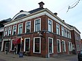
building in Kollumerland en Nieuwkruisland, Netherlands  | |||||
| Upload media | |||||
| Instance of | |||||
|---|---|---|---|---|---|
| Location | Kollum, Noardeast-Fryslân, Friesland, Netherlands | ||||
| Street address |
| ||||
| Located on street |
| ||||
| Heritage designation |
| ||||
 | |||||
Nederlands: Huis "De Roskam"
|
This is a category about rijksmonument number 23736
|
| Address |
|
Media in category "Voorstraat 63, Kollum"
The following 8 files are in this category, out of 8 total.
-
 De Roskam, Voorstraat 63, Kollum.JPG 4,608 × 3,456; 3.09 MB
-
 Exterieur OVERZICHT VOORGEVELS - Kollum - 20277036 - RCE.jpg 1,200 × 960; 263 KB
-
 Exterieur VOORGEVEL - Kollum - 20292026 - RCE.jpg 1,200 × 775; 226 KB
-
 Exterieur VOORGEVEL, RECHTER ZIJGEVEL - Kollum - 20277027 - RCE.jpg 1,200 × 1,199; 302 KB
-
 Hoek Westerdiepwal, zie nr.63 - Kollum - 20126619 - RCE.jpg 805 × 1,200; 181 KB
-
 Kollum - De Roskam.jpg 3,733 × 2,800; 3.39 MB
-

-
 Voor- en zijgevel - Kollum - 20126636 - RCE.jpg 1,200 × 805; 209 KB


