Category:Walenburg, Langbroek
Jump to navigation
Jump to search
| Object location | | View all coordinates using: OpenStreetMap |
|---|
 | |||||
| Upload media | |||||
| Instance of | |||||
|---|---|---|---|---|---|
| Part of | |||||
| Location | Langbroek, Utrecht, Netherlands | ||||
| Street address |
| ||||
| Located on street |
| ||||
| Heritage designation |
| ||||
 | |||||
Link Kasteel Walenburg
|
This is a category about rijksmonumentcomplex number 510850
|
Huis:
|
This is a category about rijksmonument number 510848
|
Tuin:
|
This is a category about rijksmonument number 510851
|
| Address |
|
Media in category "Walenburg, Langbroek"
The following 45 files are in this category, out of 45 total.
-
-
 Aanzicht exterieur - Neerlangbroek - 20162995 - RCE.jpg 951 × 1,200; 340 KB
-
 Barometer in bezit van Dhr. Canneman - Neerlangbroek - 20163013 - RCE.jpg 1,195 × 1,200; 189 KB
-

-
 Detail barometer in bezit van Dhr.Canneman - Neerlangbroek - 20163014 - RCE.jpg 1,188 × 1,200; 191 KB
-
 Detail interieur eetkamer - Neerlangbroek - 20163006 - RCE.jpg 951 × 1,200; 191 KB
-
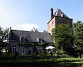
 Exterieur - Neerlangbroek - 20162991 - RCE.jpg 976 × 1,200; 289 KB
-
 Exterieur OVERZICHT TUINZIJDE - Langbroek - 20314149 - RCE.jpg 1,195 × 1,200; 409 KB
-
 Gezicht op kasteel Walenburg te Langbroek. NL-HlmNHA 1477 53011981.JPG 3,498 × 2,331; 2.77 MB
-
 Gezicht op kasteel Walenburg, Nederlangbroek. NL-HlmNHA 1477 53009594.JPG 3,699 × 2,469; 3.32 MB
-

-

-

-

-

-

-

-

-
 Interieur eetkamer - Neerlangbroek - 20163004 - RCE.jpg 957 × 1,200; 233 KB
-
 Interieur eetkamer - Neerlangbroek - 20163005 - RCE.jpg 955 × 1,200; 238 KB
-
 Interieur hal - Neerlangbroek - 20163001 - RCE.jpg 1,200 × 953; 180 KB
-
 Interieur hal - Neerlangbroek - 20163002 - RCE.jpg 1,200 × 960; 178 KB
-
 Interieur werkkamer in toren - Neerlangbroek - 20163008 - RCE.jpg 1,200 × 957; 247 KB
-
 Interieur woonkamer - Neerlangbroek - 20163003 - RCE.jpg 1,200 × 955; 231 KB
-
 Kasteel Walenburg.jpg 3,997 × 2,998; 4.68 MB
-
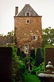
 Langbroek - Walenburg met brug RM510848.JPG 4,104 × 3,336; 4.65 MB
-
 Langbroek - Walenburg RM510848.JPG 4,125 × 3,321; 3.23 MB
-
 Langbroek - Walenburg toegangsbrug RM510851.JPG 4,608 × 3,456; 2.19 MB
-
 Langbroek - Walenburg tuin RM510851.JPG 3,456 × 4,608; 1.85 MB
-
 Langbroek - Walenburg voorburcht RM510851.JPG 3,207 × 3,070; 1.56 MB
-
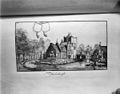
 Naar tekening - Neerlangbroek - 20162993 - RCE.jpg 1,200 × 951; 239 KB
-
 Overloop gezien vanuit werkkamer - Neerlangbroek - 20163009 - RCE.jpg 959 × 1,200; 230 KB
-
 Overloop naar toren (werkkamer) - Neerlangbroek - 20163007 - RCE.jpg 955 × 1,200; 226 KB
-
 Overzicht exterieur zuid-west zijde - Neerlangbroek - 20162998 - RCE.jpg 1,200 × 957; 359 KB
-
 Overzicht noord-west zijde - Neerlangbroek - 20163000 - RCE.jpg 1,200 × 955; 369 KB
-
 Overzicht westzijde exterieur - Neerlangbroek - 20162999 - RCE.jpg 1,200 × 960; 407 KB
-
 Overzicht zuid-west zijde. - Neerlangbroek - 20162997 - RCE.jpg 946 × 1,200; 360 KB
-
 Overzicht zuidzijde. - Neerlangbroek - 20162996 - RCE.jpg 1,200 × 955; 282 KB
-
 Prent in bezit van Dhr. Canneman - Neerlangbroek - 20163011 - RCE.jpg 1,200 × 1,197; 382 KB
-
 Prent in bezit van Dhr. Canneman - Neerlangbroek - 20163012 - RCE.jpg 1,190 × 1,200; 385 KB
-
 Ridderhofstad - Neerlangbroek - 20162992 - RCE.jpg 915 × 1,200; 299 KB
-
 Torenslaapkamer met gewelf. - Neerlangbroek - 20163010 - RCE.jpg 963 × 1,200; 143 KB
-
 Utrechts pijpaarden beeldje - Neerlangbroek - 20406921 - RCE.jpg 1,200 × 974; 215 KB
-
 Walenburg juni 1987.JPG 2,432 × 3,648; 5.56 MB
-
 Walenburg.jpg 3,008 × 2,000; 8.06 MB


_-_Neerlangbroek_-_20163007_-_RCE.jpg)


