Category:Walkway Over the Hudson
Zur Navigation springen
Zur Suche springen
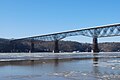
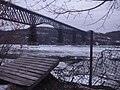
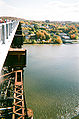
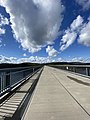
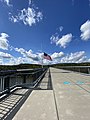
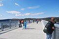
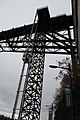
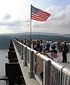
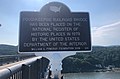
English: Conceived in the 1860s, the Poughkeepsie-Highland Railroad Bridge, also known as the Poughkeepsie Bridge, was built by the Manhattan Bridge Company and was completed in 1889, becoming the only crossing of the Hudson river between New York City and Albany. The cost of the project was $3.5 million. Including its overland approaches, it is 6,768 feel (1.28 miles) long, of which 3,094 feet (0.59 miles) are over water. The deck stands 212 feet above the river. At the time, it opened it was the longest cantilever truss span bridge in the world. Connected to the nationwide rail system, trains carried goods to and from the west and New England. During World War II, more than 3,500 rail cars a day passed over the bridge. In the late 20th century, with growth of trucking and the creation of the Interstate Highway System, the bridge's volume decreased dramatically. A fire in 1974 damaged it, and it was abandoned by the 1980's. The bridge was redeveloped as a pedestrian bridge, and re-opened in 2009. It is now the second-longest pedestrian bridge in the world. (Source: Signs on site)
NOTE: Pictures of the pedestrian bridge, i.e. 2009 and after, go here. Pictures prior to 2009 should go in Category:Poughkeepsie-Highland Railroad Bridge
Brücke in den Vereinigten Staaten  | |||||
| Medium hochladen | |||||
| Ist ein(e) |
| ||||
|---|---|---|---|---|---|
| Liegt in Schutzgebiet |
| ||||
| Ort |
| ||||
| Physisch verbunden mit | |||||
| Querung | |||||
| Überführt |
| ||||
| Besteht aus |
| ||||
| Schutzkategorie |
| ||||
| Datum der Gründung, Erstellung, Entstehung, Erbauung |
| ||||
| Eröffnungsdatum |
| ||||
| Schließungsdatum |
| ||||
| Länge |
| ||||
| Höhe |
| ||||
| Verschieden von | |||||
| offizielle Website | |||||
 | |||||
Unterkategorien
Es werden 2 von insgesamt 2 Unterkategorien in dieser Kategorie angezeigt:
In Klammern die Anzahl der enthaltenen Kategorien (K), Seiten (S), Dateien (D)
P
V
Seiten in der Kategorie „Walkway Over the Hudson“
Diese Kategorie enthält nur die folgende Seite.
Medien in der Kategorie „Walkway Over the Hudson“
Folgende 65 Dateien sind in dieser Kategorie, von 65 insgesamt.
-
 00000IMG 00000 BURST20191106134153990 COVER (1).jpg 4.032 × 3.024; 2,09 MB
-
 06 Walkway Over the Hudson.jpg 4.123 × 1.257; 2,05 MB
-
 2009 Mid-Hudson balloon festival.JPG 3.872 × 2.592; 3,35 MB
-
 American Flag at Walkway Over the Hudson 2.JPG 2.592 × 3.872; 3,47 MB
-
 American Flag at Walkway Over the Hudson.JPG 2.480 × 3.784; 2,44 MB
-
 Attraction signs near Walkway Over the Hudson.jpg 3.264 × 2.448; 4,17 MB
-
 Empire State Trail sign and other trail signage.jpg 2.448 × 3.264; 3,8 MB
-
 Empire State Trail sign at Walkway Over The Hudson parking lot.jpg 2.448 × 3.264; 2,44 MB
-
 Fourth of July 2012.jpg 4.608 × 3.456; 590 KB
-
 Highland and Poughkeepsie Walkabout 2.jpg 3.932 × 2.850; 1,57 MB
-
 Highland and Poughkeepsie Walkabout 4.jpg 2.952 × 3.936; 1,95 MB
-
 Highland and Poughkeepsie Walkabout 5.jpg 2.968 × 3.968; 3,14 MB
-
 Highland and Poughkeepsie Walkabout.jpg 2.944 × 3.928; 1,42 MB
-
 Hudson River from Waryas Park in Poughkeepsie, NY 2.JPG 3.872 × 2.592; 3,59 MB
-
 Hudson River from Waryas Park in Poughkeepsie, NY 3.JPG 3.872 × 2.592; 4,16 MB
-
 Hudson River from Waryas Park in Poughkeepsie, NY 4.JPG 3.872 × 2.592; 4,29 MB
-
 Hudson River from Waryas Park in Poughkeepsie, NY.JPG 3.872 × 2.592; 3,88 MB
-
 MidHuson Trail bridge.jpg 4.404 × 5.504; 20,6 MB
-
 Po'keepsie, NY (15831896524).jpg 1.280 × 960; 306 KB
-
 Poughkeepsie Bridge detail.jpg 1.024 × 1.545; 580 KB
-
 Poughkeepsie Bridge from Mid-Hudson Bridge NY1.jpg 5.472 × 1.800; 3,68 MB
-
 Poughkeepsie Railroad Bridge Walkway Over the Hudson, Poughkeepsie, NY 01.jpg 3.024 × 4.032; 4,34 MB
-
 Poughkeepsie Railroad Bridge Walkway Over the Hudson, Poughkeepsie, NY 03.jpg 3.024 × 4.032; 5,02 MB
-
 Poughkeepsie Railroad Bridge Walkway Over the Hudson, Poughkeepsie, NY 05.jpg 3.024 × 4.032; 3,62 MB
-
 Poughkeepsie Railroad Bridge Walkway Over the Hudson, Poughkeepsie, NY 08.jpg 3.024 × 4.032; 2,77 MB
-
 Poughkeepsie Railroad Bridge Walkway Over the Hudson, Poughkeepsie, NY 09.jpg 4.032 × 3.024; 2,62 MB
-
 Poughkeepsie Railroad Bridge Walkway Over the Hudson, Poughkeepsie, NY 10.jpg 4.032 × 3.024; 3,2 MB
-
 Poughkeepsie Railroad Bridge Walkway Over the Hudson, Poughkeepsie, NY 11.jpg 3.024 × 4.032; 2,69 MB
-
 Poughkeepsie Railroad Bridge Walkway Over the Hudson, Poughkeepsie, NY 12.jpg 3.024 × 4.032; 3,86 MB
-
 Poughkeepsie Railroad Bridge, Hudson Valley.jpg 1.024 × 576; 338 KB
-
 Poughkeepsie walkway.JPG 640 × 480; 32 KB
-
 Poughkeepsie-bridges.jpg 3.072 × 2.304; 1,17 MB
-
 US 9 in NY birds-eye view.JPG 3.764 × 2.428; 3,53 MB
-

-
 Walkway Over the Hudson 1.JPG 3.872 × 2.592; 3,06 MB
-
 Walkway Over the Hudson 2.JPG 3.872 × 2.592; 3,21 MB
-
 Walkway Over the Hudson 2010-05-31.JPG 3.812 × 2.500; 3,43 MB
-
 Walkway Over the Hudson 3.JPG 3.872 × 2.592; 3,22 MB
-
 Walkway Over the Hudson 4.JPG 3.872 × 2.592; 2,97 MB
-
 Walkway Over the Hudson 5.JPG 3.872 × 2.592; 3,27 MB
-
 Walkway Over the Hudson 6.JPG 3.872 × 2.592; 3,56 MB
-
 Walkway Over the Hudson 7.JPG 3.872 × 2.592; 4,15 MB
-
 Walkway Over the Hudson Elevator.JPG 3.456 × 5.184; 5,75 MB
-
 Walkway Over the Hudson Highland side.JPG 3.872 × 2.592; 3,86 MB
-
 Walkway Over the Hudson in winter 2.JPG 3.872 × 2.592; 2,89 MB
-
 Walkway Over the Hudson in winter 3.JPG 3.872 × 2.592; 2,32 MB
-
 Walkway Over the Hudson in winter 4.JPG 3.872 × 2.592; 2,7 MB
-
 Walkway Over the Hudson on a foggy day.JPG 3.872 × 2.592; 3,18 MB
-
 Walkway over the Hudson opening day.JPG 1.554 × 1.890; 1,68 MB
-
 Walkway Over the Hudson panorama 2.jpg 7.576 × 1.544; 994 KB
-
 Walkway Over the Hudson panorama north-east.jpg 7.368 × 1.544; 1 MB
-
 Walkway Over the Hudson panorama.jpg 4.988 × 1.590; 756 KB
-
 Walkway Over the Hudson Poughkeepsie entrance 2.JPG 3.872 × 2.592; 4,23 MB
-
 Walkway Over the Hudson Poughkeepsie entrance.JPG 3.872 × 2.592; 4,11 MB
-
 Walkway Over the Hudson Poughkeepsie side.JPG 3.836 × 2.516; 3,72 MB
-
 Walkway Over the Hudson spring 2010 looking west.JPG 3.872 × 2.592; 3,61 MB
-
 Walkway Over the Hudson, Poughkeepsie NY - panoramio.jpg 3.072 × 2.304; 1,09 MB
-
 Walkway over the Hudson, Poughkeepsie-Highland, NY Railroad Bridge.jpg 4.608 × 3.456; 7,17 MB
-
 Walkway, Highland side, north view - panoramio.jpg 8.511 × 2.102; 9,43 MB
-
 Walkway, Highland side, south view - panoramio.jpg 7.704 × 1.496; 5,83 MB
-
 Walkway, Pok side, north view - panoramio.jpg 7.412 × 1.365; 5,02 MB
-
 Walkway, Pok side, south view - panoramio.jpg 7.253 × 1.383; 4,42 MB
-
 Walkway005.jpg 3.072 × 2.304; 1,27 MB
-
 Walkway006.jpg 3.072 × 2.304; 1,16 MB
-
 WalkwayOverTheHudson.jpg 2.978 × 1.965; 860 KB
.jpg)


.jpg)


.jpg)


Kategorien:
- Poughkeepsie, New York
- Bridges in Ulster County, New York
- Bridges in Dutchess County, New York
- National Register of Historic Places in Dutchess County, New York
- National Register of Historic Places in Ulster County, New York
- Rail trail bridges in New York (state)
- State parks of New York (state)
- Trails in New York (state)
- Built in New York (state) in 1889
- Bridges over the Hudson River
- Cantilever bridges in the United States
- Pedestrian and bicycle bridges in the United States
- Bridges in the United States completed in 1889
- Maybrook Line
- National Historic Civil Engineering Landmarks
- Rail lines abandoned by Conrail
- NY400
- Bridges with 7 spans
- Bridges across county lines