Category:Wardle, Greater Manchester
Jump to navigation
Jump to search
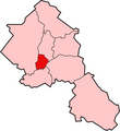
English: Wardle (pop. 7,092) is a village within the Metropolitan Borough of Rochdale, in Greater Manchester, England. It lies amongst the foothills of the Pennines, north-northeast of the city of Manchester.
village in Greater Manchester, UK  | |||||
| Upload media | |||||
| Instance of | |||||
|---|---|---|---|---|---|
| Location | Rochdale, Greater Manchester, North West England, England | ||||
 | |||||
Subcategories
This category has the following 4 subcategories, out of 4 total.
Media in category "Wardle, Greater Manchester"
The following 116 files are in this category, out of 116 total.
-
 Allotments between the houses - geograph.org.uk - 2219146.jpg 3,872 × 2,592; 3.82 MB
-
 Approaching Clough House Farm - geograph.org.uk - 4555611.jpg 1,600 × 1,200; 688 KB
-
 Approaching Stid Fold Farm - geograph.org.uk - 4555631.jpg 1,600 × 1,200; 852 KB
-

-
 Birch Road - geograph.org.uk - 1703882.jpg 1,024 × 770; 229 KB
-
 Boundary Stone - geograph.org.uk - 995976.jpg 640 × 480; 137 KB
-
 Boundary stone on Brown Wardle - geograph.org.uk - 2471513.jpg 3,872 × 2,592; 4.26 MB
-
 Bridleway between Wardle and Shore - geograph.org.uk - 377823.jpg 640 × 466; 147 KB
-

-
 Ciss Hill - geograph.org.uk - 3047672.jpg 3,872 × 2,592; 4.44 MB
-
 Clough House Brook - geograph.org.uk - 2290323.jpg 1,280 × 960; 765 KB
-
 Clough House Brook - geograph.org.uk - 2290330.jpg 1,280 × 960; 940 KB
-
 Clough House Brook - geograph.org.uk - 2290336.jpg 1,280 × 960; 908 KB
-
 Clough House Lane - geograph.org.uk - 2290303.jpg 1,280 × 960; 617 KB
-
 Clough House Lane - geograph.org.uk - 2290313.jpg 3,648 × 2,736; 4.85 MB
-
 Clough House Lane - geograph.org.uk - 2290341.jpg 1,280 × 960; 980 KB
-
 Farmland near Wardle - geograph.org.uk - 5946556.jpg 640 × 434; 100 KB
-
 Footbridge near the top of Ramsden Clough - geograph.org.uk - 2959944.jpg 3,872 × 2,592; 5.81 MB
-
 Footpath behind Shaftesbury Drive, Wardle - geograph.org.uk - 2219154.jpg 3,872 × 2,592; 4.09 MB
-
 Footpath onto Ramsden Road, Wardle - geograph.org.uk - 2218954.jpg 2,592 × 3,872; 4.78 MB
-
 Footpath towards Wardle - geograph.org.uk - 5946552.jpg 640 × 475; 150 KB
-
 Former Post Office on Ramsden Road, Wardle - geograph.org.uk - 5947618.jpg 3,859 × 3,378; 2.73 MB
-
 Former track towards Lobden House - geograph.org.uk - 3047683.jpg 3,872 × 2,592; 4.96 MB
-
 Grazing, Wardle - geograph.org.uk - 5946557.jpg 640 × 428; 145 KB
-

-
 Hare ^ Hounds pub at Wardle - geograph.org.uk - 4555591.jpg 1,600 × 1,200; 475 KB
-
 High Lee Slack - geograph.org.uk - 727551.jpg 640 × 477; 83 KB
-
 Higher Slack Brook - geograph.org.uk - 4406362.jpg 1,600 × 1,200; 768 KB
-
 Horses grazing on the edge of Wardle - geograph.org.uk - 2219163.jpg 3,872 × 2,592; 2.81 MB
-
 Houses on Ramsden Road, Wardle - geograph.org.uk - 5946567.jpg 640 × 480; 71 KB
-
 Houses on Ramsden Road, Wardle - geograph.org.uk - 5946573.jpg 640 × 417; 73 KB
-
 Houses on Wardle Road, Wardle - geograph.org.uk - 5947627.jpg 5,184 × 3,888; 5.7 MB
-
 Hursthead Nook - geograph.org.uk - 2290304.jpg 1,280 × 960; 679 KB
-
 Kingdom Hall of Jehovah's Witnesses - geograph.org.uk - 1864748.jpg 1,600 × 1,200; 585 KB
-
 Knowl Syke Brook - geograph.org.uk - 2290299.jpg 1,280 × 960; 880 KB
-
 Knowl Syke Street, Wardle - geograph.org.uk - 2290232.jpg 1,280 × 960; 574 KB
-
 Lane leading to the former Lawflat Mill - geograph.org.uk - 859197.jpg 640 × 467; 136 KB
-
 Lower House Lane, Wardle - geograph.org.uk - 2290297.jpg 1,280 × 960; 944 KB
-
 Old Boundary Marker - geograph.org.uk - 6445821.jpg 768 × 1,024; 279 KB
-
 Old Boundary Marker - geograph.org.uk - 6445823.jpg 769 × 1,024; 348 KB
-
 Old Boundary Marker - geograph.org.uk - 6445832.jpg 768 × 1,024; 378 KB
-
 Old Boundary Marker - geograph.org.uk - 6445836.jpg 768 × 1,024; 412 KB
-
 Old Boundary Marker - geograph.org.uk - 6445839.jpg 768 × 1,024; 267 KB
-
 Old mill pond near Wardle, Lancashire - geograph.org.uk - 57074.jpg 640 × 480; 109 KB
-
 Old pond near Wardle - geograph.org.uk - 2192965.jpg 2,272 × 1,704; 887 KB
-
 Old road above Watergrove, Wardle - geograph.org.uk - 89458.jpg 640 × 480; 118 KB
-
 Overhead cables near Wardle - geograph.org.uk - 2224560.jpg 3,872 × 2,592; 2.52 MB
-
 Pennine Bridleway, Dobbin Hill - geograph.org.uk - 377853.jpg 640 × 480; 97 KB
-
 Polling Station Wardle - geograph.org.uk - 1843537.jpg 640 × 480; 92 KB
-
 Pool on Brown Wardle Hill - geograph.org.uk - 3418092.jpg 4,320 × 3,240; 4.65 MB
-
 Post box, Wardle - geograph.org.uk - 2619542.jpg 463 × 640; 136 KB
-
 Ramsden Road - geograph.org.uk - 1703921.jpg 1,024 × 768; 258 KB
-
 Ramsden Road - geograph.org.uk - 5381391.jpg 4,352 × 2,479; 1.98 MB
-
 Ramsden Road, Wardle - geograph.org.uk - 2224570.jpg 3,872 × 2,592; 2.84 MB
-
 Ramsden Road, Wardle - geograph.org.uk - 2289412.jpg 1,280 × 960; 795 KB
-
 Ramsden Road, Wardle - geograph.org.uk - 2290228.jpg 1,280 × 960; 722 KB
-
 Ramsden Road, Wardle - geograph.org.uk - 40050.jpg 640 × 480; 105 KB
-
 Ramsden Road, Wardle - geograph.org.uk - 5946571.jpg 640 × 444; 60 KB
-
 Ramsden Road, Wardle - geograph.org.uk - 5946574.jpg 640 × 480; 86 KB
-
 Remembrance Sunday 2014 - geograph.org.uk - 4690995.jpg 640 × 427; 148 KB
-
 Reservoir below Rydings Farm - geograph.org.uk - 3047660.jpg 3,872 × 2,592; 4.83 MB
-
 Reservoir north of Flower Hill Farm - geograph.org.uk - 4555621.jpg 1,600 × 1,200; 542 KB
-
 Road To Benthead Farm And Hursthead Nook - geograph.org.uk - 2290302.jpg 1,280 × 960; 670 KB
-
 Roads Farm - geograph.org.uk - 370478.jpg 640 × 480; 163 KB
-

-
 Rydings Lane, rural Rochdale - geograph.org.uk - 1932851.jpg 640 × 480; 88 KB
-
 Sign for the Hare ^ Hounds, Wardle - geograph.org.uk - 5946566.jpg 391 × 640; 59 KB
-
 St James Church Wardle - geograph.org.uk - 1703926.jpg 1,024 × 768; 269 KB
-
 St James Church, Wardle - geograph.org.uk - 1703937.jpg 1,024 × 768; 216 KB
-
 Stepping Stones - geograph.org.uk - 623524.jpg 640 × 480; 151 KB
-
 Steward Barn - geograph.org.uk - 5381386.jpg 4,352 × 2,904; 1.71 MB
-
 Stid Fold, Wardle, Lancashire (1) - geograph.org.uk - 560513.jpg 640 × 498; 85 KB
-
 Stid Fold, Wardle, Lancashire (2) - geograph.org.uk - 560526.jpg 640 × 521; 72 KB
-
 Stid Fold, Wardle, Lancashire (3) - geograph.org.uk - 560534.jpg 640 × 497; 86 KB
-
 Stile below Brown Hill - geograph.org.uk - 4406398.jpg 1,600 × 1,200; 461 KB
-
 Stone shelter on Crook Hill - geograph.org.uk - 100842.jpg 640 × 455; 137 KB
-
 The entrance to Higher Slack Brook Nature Reserve - geograph.org.uk - 2223551.jpg 3,872 × 2,592; 4.68 MB
-
 The Filter House at Watergrove Reservoir - geograph.org.uk - 739739.jpg 640 × 422; 108 KB
-
 The Globe Inn - geograph.org.uk - 1703954.jpg 1,024 × 768; 207 KB
-
 The Hare ^ Hounds, Wardle - geograph.org.uk - 5946565.jpg 640 × 443; 65 KB
-
 The Village Butchers - geograph.org.uk - 1703877.jpg 1,024 × 768; 253 KB
-
 Track towards Wardle Fold - geograph.org.uk - 4555580.jpg 1,600 × 1,200; 525 KB
-
 Union Road, Wardle - geograph.org.uk - 2427772.jpg 2,592 × 1,944; 844 KB
-
 View of Wardle.jpg 1,600 × 1,200; 251 KB
-
 View over Wardle, in Greater Manchester, England - Geograph-2290339.jpg 1,280 × 960; 889 KB
-
 View to Tab Road Farm - geograph.org.uk - 1778702.jpg 2,816 × 2,112; 1 MB
-
 View Towards Wardle From Watergrove - geograph.org.uk - 2289417.jpg 1,280 × 960; 916 KB
-
 Wardle - Lawflat Mill.jpg 640 × 474; 147 KB
-
 Wardle Academy - geograph.org.uk - 3695561.jpg 640 × 244; 94 KB
-
 Wardle All Stars.png 585 × 561; 62 KB
-
 Wardle Brook - geograph.org.uk - 2289425.jpg 1,280 × 960; 828 KB
-
 Wardle FC.png 582 × 950; 105 KB
-
 Wardle Fold - geograph.org.uk - 681836.jpg 640 × 476; 111 KB
-
 Wardle from the east - geograph.org.uk - 2219157.jpg 3,872 × 2,592; 2.9 MB
-
 Wardle from Watergrove Reservoir - geograph.org.uk - 2607691.jpg 4,000 × 3,000; 1.7 MB
-

-
 Wardle Library - geograph.org.uk - 1703869.jpg 1,024 × 768; 186 KB
-
 Wardle Library - geograph.org.uk - 5946559.jpg 640 × 475; 63 KB
-
 Wardle Post Office and newsagents - geograph.org.uk - 5946563.jpg 640 × 480; 82 KB
-
 Wardle Road - geograph.org.uk - 5946562.jpg 640 × 480; 71 KB
-
 Wardle Village Church - geograph.org.uk - 1703947.jpg 1,024 × 768; 201 KB
-
 Wardle Village Church - geograph.org.uk - 2945110.jpg 4,000 × 3,000; 5.41 MB
-
 Wardle Village Church - geograph.org.uk - 681848.jpg 640 × 451; 75 KB
-
 Wardle Village Post Office - geograph.org.uk - 1703864.jpg 1,024 × 768; 267 KB
-
 Wardle Village Square - geograph.org.uk - 681882.jpg 640 × 428; 74 KB
-
 Wardle, Lancashire - geograph.org.uk - 343221.jpg 640 × 489; 82 KB
-
 WardleworthRochdaleAncientParish.png 450 × 492; 24 KB
-
 Water Grove Trig Point - geograph.org.uk - 4069057.jpg 2,478 × 1,767; 3.08 MB
-
 Water Grove trig point - geograph.org.uk - 4406284.jpg 1,600 × 1,200; 548 KB
-
 Weaver's cottages, Wardle - geograph.org.uk - 2427707.jpg 2,592 × 1,944; 981 KB
-
 Weavers' cottages, Wardle.jpg 366 × 392; 140 KB
-
 Welcome to Wardle - geograph.org.uk - 2427790.jpg 1,944 × 2,592; 621 KB
-
 WuerdleAndWardleRochdaleAncientParish.png 450 × 492; 25 KB
-
 Abandoned Fields, Wardle - geograph.org.uk - 91277.jpg 640 × 474; 97 KB
-
 Library and Shops, Wardle - geograph.org.uk - 377744.jpg 640 × 464; 101 KB
-
 Rear of Wardle Village Church - geograph.org.uk - 681861.jpg 640 × 480; 134 KB


_-_geograph.org.uk_-_1873796.jpg)


_-_geograph.org.uk_-_560513.jpg)
_-_geograph.org.uk_-_560526.jpg)
_-_geograph.org.uk_-_560534.jpg)


