Category:Washington State Route 410
Jump to navigation
Jump to search
highway in Washington  | |||||
| Upload media | |||||
| Instance of | |||||
|---|---|---|---|---|---|
| Located in protected area | |||||
| Location | Washington, Pacific Northwest, Washington, Pacific States Region | ||||
| Transport network | |||||
| Owned by | |||||
| Maintained by | |||||
| Inception |
| ||||
| Length |
| ||||
| |||||
| « First · 397 · 401 · 403 · 407 · 409 · 410 · 411 · 431 · Last » |
| I-5 · I-82 · I-90 · I-182 · I-205 · I-405 · I-605 · I-705 |
| US-2 · US-10 · US-12 · US-95 · US-97 · US-99 · US-101 · US-195 · US-197 · US-295 · US-395 · US-730 · US-830 |
English: This category should contain files related to Washington State Route 410.
Subcategories
This category has the following 9 subcategories, out of 9 total.
B
C
- Chinook Pass (11 F)
D
G
- Greenwater General Store (4 F)
M
N
- Northeast Entrance Arch (11 F)
W
- White River Bridge (SR 410) (4 F)
Media in category "Washington State Route 410"
The following 32 files are in this category, out of 32 total.
-
 WA-410.svg 600 × 600; 6 KB
-
 Clearwater Lodge on Greenwater River 01.jpg 4,288 × 2,848; 6.41 MB
-
 Downstream on Greenwater River from WA SR 410 - 01.jpg 4,288 × 2,848; 6.31 MB
-
 Entering King County on WA SR 410 - 01.jpg 4,288 × 2,848; 6.17 MB
-
 Entering Pierce County on WA SR 410 - 01.jpg 2,848 × 4,288; 6 MB
-
 Entering Pierce County on WA SR 410 - 02.jpg 4,288 × 2,848; 6.46 MB
-
 Entering Pierce County on WA SR 410 - 03.jpg 4,288 × 2,848; 6.31 MB
-
 Greenwater, WA — Naches Tavern.jpg 4,752 × 3,168; 16.21 MB
-
 Highway 410 and White River. 101967. slide (544ed736225a4da6a2e6fbc887013c32).jpg 2,140 × 1,457; 912 KB
-
 Hwy 123 Sign Install 5 (6973380720).jpg 3,072 × 2,304; 1.4 MB
-
-
 Moss on Greenwater River bridge, WA SR 410.jpg 4,288 × 2,848; 6.86 MB
-
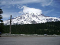
 Mount Rainier 2023-06-30 03.jpg 6,000 × 4,000; 4.58 MB
-
 Mt. Rainier (5559658987).jpg 1,000 × 750; 276 KB
-
 Naches Peak from Highway 410 switchbacks.jpg 2,264 × 1,525; 1.07 MB
-
 Peak of Mount Rainier from Washington SR 410 just south of the road to Sunrise 01.jpg 6,000 × 4,000; 8.34 MB
-
 Peak of Mount Rainier from Washington SR 410 just south of the road to Sunrise 02.jpg 6,000 × 4,000; 8.3 MB
-
 Peak of Mount Rainier from Washington SR 410 just south of the road to Sunrise 03.jpg 6,000 × 4,000; 8.5 MB
-
 Peak of Mount Rainier from Washington SR 410 just south of the road to Sunrise 04.jpg 6,000 × 4,000; 9.82 MB
-

-
 SR 123 area history.svg 1,152 × 640; 29 KB
-
 Upstream on Greenwater River from WA SR 410 - 01.jpg 4,288 × 2,848; 6.35 MB
-
 US 410 Sumner freeway topo.png 1,000 × 800; 1.67 MB
-

-

-

-
 WA 410 952.jpg 2,592 × 4,608; 2.54 MB
-
 WA 410 955.jpg 4,608 × 2,592; 2.77 MB
-
 Washington State Route 410.svg 1,152 × 640; 168 KB
-
 WashingtonSR410.jpg 2,339 × 1,167; 897 KB
-
 Weyerhauser Mainline Road Enumclaw Washington Bridge (20166044811).jpg 5,617 × 3,399; 19.79 MB
-
 White River from Washington SR 410 just south of the road to Sunrise.jpg 6,000 × 4,000; 11.71 MB


.jpg)
.jpg)


.jpg)


.jpg)
