Category:Wasserturm Altes Lager (Niedergörsdorf)
Jump to navigation
Jump to search
| Object location | | View all coordinates using: OpenStreetMap |
|---|
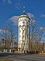
This is the category of the Brandenburger Baudenkmal (cultural heritage monument) with the ID 09105654 (Wikidata)
|
 | |||||
| Upload media | |||||
| Instance of | |||||
|---|---|---|---|---|---|
| Location | Altes Lager, Niedergörsdorf, Teltow-Fläming District, Brandenburg, Germany | ||||
| Heritage designation | |||||
 | |||||
Media in category "Wasserturm Altes Lager (Niedergörsdorf)"
The following 7 files are in this category, out of 7 total.
-
 Niedergoersdorf Altes Lager Wasserturm 1.jpg 2,736 × 3,648; 3.36 MB
-
 Niedergoersdorf Altes Lager Wasserturm-01.jpg 3,732 × 4,976; 7.97 MB
-
 Niedergoersdorf Altes Lager Wasserturm-02.jpg 3,987 × 5,316; 8.84 MB
-
 Niedergoersdorf Altes Lager Wasserturm-03.jpg 3,935 × 5,246; 10.46 MB
-
 Niedergoersdorf Altes Lager Wasserturm-04.jpg 3,911 × 5,215; 12.11 MB
-
 Niedergoersdorf Altes Lager Wasserturm.jpg 2,448 × 3,264; 2.12 MB
-
 Wasserturm Altes Lager Niedergörsdorf.jpg 2,464 × 1,632; 2.84 MB


Categories:
- Buildings in Altes Lager (Niedergörsdorf)
- Buildings in Niedergörsdorf
- Cultural heritage monuments in Niedergörsdorf
- Towers in Landkreis Teltow-Fläming
- Water towers in Brandenburg
- Former water towers
- Concrete water towers in Germany
- Concrete towers in Brandenburg
- Round towers in Brandenburg
- Built in Brandenburg in 1918