Category:Water erosion
Vai alla navigazione
Vai alla ricerca
| Carica un file multimediale | |||||
| Sottoclasse di | |||||
|---|---|---|---|---|---|
| |||||
Sottocategorie
Questa categoria contiene le 20 sottocategorie indicate di seguito, su un totale di 20.
A
B
C
D
E
F
G
K
- Kaňk (national nature monument) (21 F)
M
S
- Scour (13 F)
- Soil erosion by water (24 F)
T
W
- Waterbars (4 F)
File nella categoria "Water erosion"
Questa categoria contiene 120 file, indicati di seguito, su un totale di 120.
-
 5902-Linxia-County-Xihe-township-canyon.jpg 2 048 × 1 536; 1,56 MB
-
 A "Working Forest".jpg 511 × 345; 26 KB
-
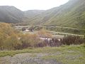
 A gully formed by water erosion.jpg 2 592 × 1 944; 2,33 MB
-
 Action du vent sur un lac.png 569 × 309; 5 KB
-
 Algue@plage(parMichelDahan).jpg 1 440 × 1 080; 665 KB
-
 Bend in the River Ashop - geograph.org.uk - 155858.jpg 640 × 480; 117 KB
-
 Bielsa - Barranco del Montillo 02.jpg 4 592 × 3 448; 18,97 MB
-
 BirlingGap(ChristineMatthews)Jul2001.jpg 421 × 640; 186 KB
-
Bohušovice nad Ohří, povodně 2013 (001).ogv 33 s, 640 × 480; 6,4 MB
-
 Błędne Skały.jpg 1 600 × 1 067; 1,18 MB
-
 Control de la eroosión en laderas.JPG 596 × 394; 66 KB
-
 Daxia-River-Valley-panorama-5902+5903+5904+5905+5906.jpg 6 737 × 1 483; 10,53 MB
-
 Dyrhólaey 04.JPG 2 586 × 3 440; 3 MB
-
 Eckbach Schwarzenbergpark Seitenerosion 2.jpg 3 141 × 2 097; 3,79 MB
-
 Eckbach Schwarzenbergpark Seitenerosion.jpg 2 850 × 4 269; 5,12 MB
-
 El Golfo - Charco de los Clicos -Lanzarote - G11.jpg 3 331 × 2 221; 5,66 MB
-
 Ellirardalur11.JPG 3 072 × 2 304; 2,97 MB
-
 Eroded Road at Whatarangi Bluff, Palliser Bay-2.jpg 3 872 × 2 592; 2,31 MB
-
 Eroded Road at Whatarangi Bluff, Palliser Bay.jpg 3 872 × 2 592; 2,37 MB
-
 Erosion - geograph.org.uk - 109145.jpg 640 × 480; 97 KB
-
 Erosion durch wasser.jpg 640 × 762; 164 KB
-
 Erosion Fremdwasser001.JPG 2 272 × 1 704; 855 KB
-
 Erosion Fremdwasser002.JPG 2 272 × 1 704; 1,54 MB
-
 Erosion Fremdwasser003.jpg 1 746 × 1 177; 1,59 MB
-
 Erosion Fremdwasser004.jpg 1 183 × 1 714; 1,46 MB
-
 Erosion Furchen001.jpg 1 560 × 1 033; 1,28 MB
-
 Erosion Furchen006.jpg 2 272 × 1 704; 1,76 MB
-
 Erosion in Rocky Mountain National Park.jpg 4 032 × 3 024; 6,25 MB
-
 Erosion par l'eau.jpg 2 560 × 1 440; 1,42 MB
-
 Erosion, Goodrington Beach - geograph.org.uk - 1764266.jpg 1 600 × 1 200; 510 KB
-
 Erosion-on- the-coast-of-Kattegat.jpg 1 360 × 913; 968 KB
-
 Erosion2.jpg 908 × 1 360; 1,08 MB
-
 Eroze fb.jpg 1 200 × 800; 870 KB
-
 Feeder bluff at Jefferson Beach.jpg 3 264 × 2 448; 3,76 MB
-
 Foamy river eroding stones.jpg 5 184 × 3 888; 6,54 MB
-
 Foothills And Fields Of Southern Alps I.jpg 1 600 × 1 200; 298 KB
-
 Foothills And Fields Of Southern Alps II.jpg 1 600 × 1 200; 188 KB
-
 Former track of Daddy longlegs 20070531.jpg 1 024 × 768; 221 KB
-
 Fälensee 1.jpg 1 408 × 1 056; 325 KB
-
 Geleise unterspült.jpg 1 600 × 1 200; 304 KB
-
 Gleithangerp.jpg 1 310 × 983; 436 KB
-
 GOR Bay of Islands -38585564 14228277.jpg 640 × 480; 152 KB
-
 GOR Bay of Islands.jpg 640 × 480; 134 KB
-
 GOR Bay of Martyrs-38599132 142859573.jpg 480 × 640; 149 KB
-
 GOR Bay of Martyrs.jpg 640 × 480; 139 KB
-
 Great Ocean Road - Bay of Islands.jpg 640 × 480; 146 KB
-
 Great Ocean Road Bay of Martyrs.jpg 480 × 640; 157 KB
-
 Helgoland Abbruch.jpg 2 816 × 2 112; 3,64 MB
-
 Heligoland Felswatt low tide.jpg 2 592 × 1 944; 1,09 MB
-
 Hiittenharju boulder field 1.JPG 3 648 × 2 736; 4,36 MB
-
 Hiittenharju boulder field 3.JPG 2 736 × 3 648; 4,27 MB
-
 Hiittenharju boulder field 4.JPG 3 648 × 2 736; 4,41 MB
-
 Image-VelikiVrag-Gulch-1399.jpg 2 048 × 1 536; 1,11 MB
-
 Island Am Rande des Hochlands 07.JPG 3 444 × 2 586; 1,5 MB
-
 Islande Jökulsárgljúfur orgues 1.jpg 1 600 × 1 200; 294 KB
-
 Islande Jökulsárgljúfur orgues 2.jpg 1 600 × 1 200; 252 KB
-
 Kerbtalerosion Kleinbreitenbach.JPG 1 536 × 2 048; 847 KB
-
 Lauchert Altstadt-Veringenstadt Schwäbische Alb.jpg 1 800 × 1 200; 2,3 MB
-
 Lob Овраг1.JPG 3 072 × 2 304; 3,08 MB
-
 Lob Овраг2.jpg 3 072 × 2 304; 6,71 MB
-
 Lob Овраг3.jpg 3 072 × 2 304; 5,49 MB
-
 Lob Овраг4.jpg 4 558 × 2 831; 12,79 MB
-
 Long stretch of pockmarked rock wall in Patuna Chasm.jpg 4 896 × 3 264; 6,41 MB
-
 Madagascar erosion.jpg 2 048 × 1 536; 1,16 MB
-
 Manu riverbank.jpg 1 500 × 1 024; 627 KB
-
 Mulde (Fluss),Prallhang,Gleithang.jpg 3 110 × 1 944; 802 KB
-
 Near Eltham - Taranaki.jpg 2 846 × 2 017; 4,89 MB
-
 Nile erosion.JPG 2 048 × 1 536; 840 KB
-
 Nipor Moälven.jpg 1 536 × 2 048; 1,2 MB
-
 Oktober2017Island 090.jpg 2 200 × 1 320; 649 KB
-
 Overhanging rock wall with pockmarks in Patuna Chasm.jpg 4 896 × 3 264; 7,01 MB
-
 Pierre@plage(parMichelDahan).jpg 1 440 × 1 080; 926 KB
-
 PikiWiki Israel 4205 furrow.jpg 1 772 × 1 333; 2,08 MB
-
 Piz Forbesch, Route bei P.3176.jpg 4 608 × 3 456; 5,41 MB
-
 Pockmarked overhanging rock wall in Patuna Chasm.jpg 3 264 × 4 896; 7,46 MB
-
 Pockmarked rock wall at a bend in Patuna Chasm.jpg 4 896 × 3 264; 7,6 MB
-
 Pockmarked rock wall in Patuna Chasm.jpg 4 896 × 3 264; 6,62 MB
-
 PSM V04 D664 River valley basin composition.jpg 1 881 × 252; 40 KB
-
 PSM V04 D664 Scratched stone from the till.jpg 1 706 × 1 933; 686 KB
-
 PSM V04 D665 Stream cutting through terrace of till.jpg 1 726 × 1 189; 583 KB
-
 PSM V04 D667 Greenland glacier shedding an iceberg.jpg 1 870 × 518; 64 KB
-
 PSM V04 D668 Loch doon.jpg 1 924 × 1 084; 696 KB
-
 PSM V04 D669 Till overlaid with boulder clay.jpg 2 031 × 649; 141 KB
-
 PSM V04 D670 Antarctic ice sheet.jpg 1 924 × 1 127; 636 KB
-
 PSM V04 D672 Erratic boulders on glaciated rocks.jpg 1 028 × 575; 206 KB
-
 PSM V04 D673 Alpine glacier.jpg 1 492 × 1 540; 635 KB
-
 PSM V04 D675 Lower reach of loch doon.jpg 1 924 × 1 091; 738 KB
-
 Puulan rantakallio Väisälänsaaren eteläpuolella.jpg 960 × 540; 239 KB
-
 Rio Cacin, Andalusia, Spain.jpg 4 296 × 2 819; 9,67 MB
-
 Rock ecology and erosion - geograph.org.uk - 638122.jpg 480 × 640; 182 KB
-
 S-SK-River-Erosion.JPG 1 704 × 2 272; 2,17 MB
-
 Sable@plage(parMichelDahan).jpg 1 440 × 1 080; 1,17 MB
-
 Sand stack erosion.jpg 2 048 × 1 536; 706 KB
-
 Sandstone erosion - Melnik, Pirin, Bulgaria.jpg 921 × 600; 191 KB
-
 Svalnipan1.JPG 3 648 × 2 736; 3,59 MB
-
 Trongisvagsfjordur and Tvoroyri Faroe Islands.JPG 3 648 × 2 736; 2,05 MB
-
 Tuff ring Caldera Blanca on Lanzarote, June 2013 (4).jpg 4 752 × 3 168; 7,23 MB
-
 Uracher Wasserfall Ausgewaschene Wurzel.jpg 2 523 × 1 654; 1,02 MB
-
 VelikiVrag-Gulch-1434.jpg 2 048 × 1 536; 1,11 MB
-
 View Of An Eroded Part Of Taieri Gorge.jpg 1 600 × 1 200; 306 KB
-
 Waikato Waitomo Area Stream.jpg 1 600 × 1 200; 548 KB
-
 Water erosion below Scarsoch Bheag - geograph.org.uk - 1367808.jpg 480 × 640; 214 KB
-
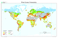 Water erosion map.png 3 400 × 2 200; 2,01 MB
-
 Water erosion, Judy Woods - geograph.org.uk - 2531967.jpg 1 024 × 768; 205 KB
-
 Water erosion.jpg 6 000 × 4 000; 5,07 MB
-
 Water-eroded track below the forest - geograph.org.uk - 598452.jpg 640 × 480; 55 KB
-
 WaterErosionSKRiver.JPG 2 272 × 1 704; 1,56 MB
-
 Waterfall Julian Alps Slovena (15).JPG 1 728 × 2 304; 2,72 MB
-
 Waterfall Julian Alps Slovena (16).JPG 1 728 × 2 304; 2,7 MB
-
 Waterfall Julian Alps Slovena (17).JPG 1 728 × 2 304; 2,74 MB
-
 Waterfall Julian Alps Slovena (18).JPG 1 728 × 2 304; 2,74 MB
-
 Waterfall Julian Alps Slovena (9).JPG 1 728 × 2 304; 2,72 MB
-
 Wavecut platform southerndown pano.jpg 2 393 × 1 200; 1,7 MB
-
 WEPP Figure1.png 1 279 × 975; 80 KB
-
 WEPP Figure2.png 1 029 × 829; 64 KB
-
 WEPP Figure3.png 1 221 × 798; 328 KB
-
 Ördög-orom Quarry Conservation Area. Difficult part. - Budapest.JPG 1 704 × 2 272; 1 019 KB
-
 Ördög-orom Quarry Conservation Area. Water washed trail. - Budapest.JPG 1 704 × 2 272; 976 KB
-
 Сток воды при орошении.png 1 461 × 832; 1,39 MB
-
 انجراف التربة.jpg 1 600 × 1 200; 411 KB


.jpg)


Jul2001.jpg)


,Prallhang,Gleithang.jpg)


.jpg)


.jpg)


.jpg)


.JPG)
.JPG)
.JPG)
.JPG)
.JPG)


