Category:Wayne County, Missouri
Zur Navigation springen
Zur Suche springen
Counties of Missouri: Adair · Andrew · Atchison · Audrain · Barry · Barton · Bates · Benton · Bollingern · Boone · Buchanan · Butler · Caldwell · Callaway · Camden · Cape Girardeau · Carroll · Carter · Cass · Cedar · Chariton · Christian · Clark · Clay · Clinton · Cole · Cooper · Crawford · Dade · Dallas · Daviess · DeKalb · Dent · Douglas · Dunklin · Franklin · Gasconade · Gentry · Greene · Grundy · Harrison · Henry · Hickory · Holt · Howard · Howell · Iron · Jackson · Jasper · Jefferson · Johnson · Knox · Laclede · Lafayette · Lawrence · Lewis · Lincoln · Linn · Livingston · Macon · Madison · Maries · Marion · McDonald · Mercer · Miller · Mississippi · Moniteau · Monroe · Montgomery · Morgan · New Madrid · Newton · Nodaway · Oregon · Osage · Ozark · Pemiscot · Perry · Pettis · Phelps · Pike · Polk · Pulaski · Putnam · Ralls · Randolph · Ray · Reynolds · Ripley · Saline · Schuyler · Scotland · Scott · Shannon · Shelby · St. Charles · St. Clair · St. Francois · St. Louis · Ste. Genevieve · Stoddard · Stone · Sullivan · Taney · Texas · Vernon · Warren · Washington · Wayne · Webster · Worth · Wright · Independent citiy: St. Louis
County im US-Bundesstaat Missouri   | |||||
| Medium hochladen | |||||
| Ist ein(e) | |||||
|---|---|---|---|---|---|
| Benannt nach | |||||
| Ort | Missouri | ||||
| Hauptstadt |
| ||||
| Datum der Gründung, Erstellung, Entstehung, Erbauung |
| ||||
| Einwohnerzahl |
| ||||
| Fläche |
| ||||
| Verschieden von | |||||
 | |||||
Unterkategorien
Es werden 5 von insgesamt 5 Unterkategorien in dieser Kategorie angezeigt:
In Klammern die Anzahl der enthaltenen Kategorien (K), Seiten (S), Dateien (D)
Medien in der Kategorie „Wayne County, Missouri“
Folgende 18 Dateien sind in dieser Kategorie, von 18 insgesamt.
-
 Aley Mountain Missouri topo map.jpg 838 × 637; 104 KB
-
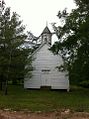 Brunot Christian Church.jpg 717 × 960; 138 KB
-
 Letter signed H.L. Butts, State of MO, Wayne Co., to cousin Hezabiah Stroup, (1865?).jpg 4.489 × 5.989; 10,81 MB
-
 Map of Missouri highlighting Wayne County.png 300 × 263; 12 KB
-
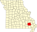 Map of Missouri highlighting Wayne County.svg 1.291 × 1.136; 98 KB
-
 MOMap-doton-Greenville.png 300 × 263; 13 KB
-
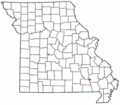 MOMap-doton-Mill Spring.png 300 × 263; 13 KB
-
 MOMap-doton-Piedmont.png 300 × 263; 13 KB
-
 MOMap-doton-Williamsville.png 300 × 263; 13 KB
-

-
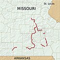 Ozark Trail completed sections w relief v1.jpg 764 × 764; 141 KB
-
 Ozark Trail completed sections w relief v3.jpg 1.214 × 924; 812 KB
-
 Piedmont Missouri.jpg 2.560 × 1.920; 2,15 MB
-
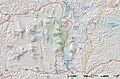 Sam A Baker SP relief topo map v1.jpg 1.409 × 932; 665 KB
-
 Sam A Baker SP relief topo map v1.png 1.409 × 932; 1,55 MB
-
 USA Wayne County, Missouri age pyramid.svg 520 × 600; 8 KB
-
 Wappapello Lake Missouri.jpg 1.500 × 1.000; 520 KB
-
 Wayne County MO Courthouse 20151021-005.jpg 5.062 × 2.406; 6,43 MB


.jpg)


.JPG)


