Category:Wegestein (Obercarsdorf)
Jump to navigation
Jump to search
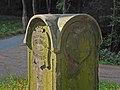
Deutsch: Wegestein in Obercarsdorf an der B171 am Abzweig zum ehem. Rittergut Naundorf.
| Object location | | View all coordinates using: OpenStreetMap |
|---|
| (Wikidata) |
| Upload media | |||||
| Instance of | |||||
|---|---|---|---|---|---|
| Location | Dippoldiswalde, Sächsische Schweiz-Osterzgebirge, Saxony, Germany | ||||
| Street address |
| ||||
| Heritage designation | |||||
| Inception |
| ||||
 | |||||
Media in category "Wegestein (Obercarsdorf)"
The following 11 files are in this category, out of 11 total.
-
 Grenzstein rittergut naundorf B171 - 1.jpg 2,336 × 4,160; 4.26 MB
-
 Grenzstein rittergut naundorf B171 - 2.jpg 2,336 × 4,160; 4.43 MB
-
 Grenzstein rittergut naundorf B171 - 3.jpg 4,160 × 2,336; 3.03 MB
-
 Grenzstein rittergut naundorf B171 - 4.jpg 2,336 × 4,160; 4.38 MB
-
 Grenzstein rittergut naundorf B171 - 5.jpg 2,336 × 4,160; 4.4 MB
-
 Obercarsdorf-Wegestein-1.jpg 2,040 × 2,720; 1.75 MB
-
 Obercarsdorf-Wegestein-2.jpg 3,141 × 2,356; 1.27 MB
-
 Obercarsdorf-Wegestein-3.jpg 3,005 × 2,254; 1.42 MB
-
 Obercarsdorf-Wegestein-4.jpg 3,227 × 2,420; 1.21 MB
-
 Obercarsdorf-Wegestein-5.jpg 2,941 × 2,206; 1.5 MB
-
 Obercarsdorf-Wegestein-6.jpg 2,885 × 2,164; 1.17 MB


