Category:Weiding (Landkreis Cham)
Jump to navigation
Jump to search
municipality in the Cham district in Bavaria, Germany   | |||||
| Upload media | |||||
| Instance of |
| ||||
|---|---|---|---|---|---|
| Part of |
| ||||
| Location | Cham, Upper Palatinate, Bavaria, Germany | ||||
| Head of government |
| ||||
| Population |
| ||||
| Area |
| ||||
| Elevation above sea level |
| ||||
| Different from | |||||
| official website | |||||
 | |||||
Subcategories
This category has the following 3 subcategories, out of 3 total.
B
H
- Karl Holmeier (4 F)
Media in category "Weiding (Landkreis Cham)"
The following 5 files are in this category, out of 5 total.
-
 DEU Weiding COA.svg 925 × 874; 32 KB
-
 Wappen Weiding.png 180 × 186; 7 KB
-
 Runding, CHA - Burgruine - Weiding, CHA - Walting v SW, Arnschwang, Furth i W.jpg 4,608 × 3,456; 1.8 MB
-
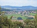
 Weiding, CHA - Dalking östl Ri N, Gleißenberg, CHA, Lixenried.jpg 4,608 × 2,592; 1.01 MB
-
 Weiding, CHA - Neumühlen östl - Weiding, CHA v SO.jpg 4,608 × 2,592; 663 KB


