Category:Weinstraße 66 (Forst an der Weinstraße)
Jump to navigation
Jump to search
| Object location | | View all coordinates using: OpenStreetMap |
|---|

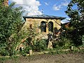
Weinstraße 66 and 68 double estate
- Plaster buildings on semi-basement, no. 66 designated 1772, farm buildings, one designated 1732.
- No. 68 designated 1807, partly older (designated 1766), jamb wall and gable roof late 19th century.
- Farmyard, storage building designated 1741, extension 19th century.
- In the garden summer house, tea-house with a pyramid roof, remains of a pergola.
- Associated vineyard "Im Kirchenstück", in the end wall Cyriakus relief, designated 1937 by Fritz Herrfurth.
Media in category "Weinstraße 66 (Forst an der Weinstraße)"
The following 4 files are in this category, out of 4 total.
-
 065 2015 06 16 Kulturdenkmaeler Forst.jpg 1,959 × 2,552; 3.78 MB
-
 066 2015 06 16 Kulturdenkmaeler Forst.jpg 2,236 × 2,236; 3.62 MB
-
 067 2015 04 10 Kulturdenkmaeler Forst.jpg 2,278 × 2,194; 3.26 MB
-
 20201010Weinstraße 66 Forst.jpg 3,250 × 2,438; 2.72 MB


