Category:West Down
Aller à la navigation
Aller à la recherche
English: West Down is a civil parish and village located in North Devon, England, between Braunton and Ilfracombe. In 2001 its population was 620.
village britannique  | |||||
| Téléverser des médias | |||||
| Nature de l’élément | |||||
|---|---|---|---|---|---|
| Lieu | North Devon, Devon, Angleterre du Sud-Ouest, Angleterre | ||||
 | |||||
Sous-catégories
Cette catégorie comprend 3 sous-catégories, dont les 3 ci-dessous.
Média dans la catégorie « West Down »
Cette catégorie comprend 312 fichiers, dont les 200 ci-dessous.
(page précédente) (page suivante)-

-

-

-
 A bridge over the river Caen at Aylescott Hill - geograph.org.uk - 2176429.jpg 1 024 × 680 ; 277 kio
-
 A bridge over the river Caen at Little Comfort Farm - geograph.org.uk - 2211244.jpg 1 024 × 680 ; 197 kio
-
 A bridge over the river Caen at Little Comfort Farm - geograph.org.uk - 2211249.jpg 1 024 × 680 ; 220 kio
-

-

-

-
 A bridge over the river Caen on Aylescott Hill - geograph.org.uk - 1672235.jpg 640 × 480 ; 125 kio
-
 A bridge over the river Caen on Aylescott Hill - geograph.org.uk - 1672241.jpg 640 × 480 ; 111 kio
-
 A bridge over the river Caen on Aylescott Hill - geograph.org.uk - 2176428.jpg 1 024 × 680 ; 328 kio
-

-
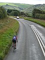 A cyclist on the A361 south of Ilfracombe - geograph.org.uk - 1519159.jpg 480 × 640 ; 72 kio
-
 A distant barn near West Stowford Barton - geograph.org.uk - 1654471.jpg 640 × 335 ; 33 kio
-

-
 A footpath leading away from West Down Hill - geograph.org.uk - 1654457.jpg 640 × 480 ; 59 kio
-

-
 A footpath near Little Stowford which leads to the B3230 - geograph.org.uk - 2176425.jpg 1 024 × 680 ; 240 kio
-
 A ford through the River Caen near Stocklands Lane - geograph.org.uk - 2082955.jpg 1 024 × 680 ; 229 kio
-
 A gated track which leads to a small field - geograph.org.uk - 1967205.jpg 1 024 × 680 ; 278 kio
-

-
 A kissing gate at the end of Stocklands Lane - geograph.org.uk - 2082074.jpg 1 024 × 680 ; 268 kio
-

-
 A kissing gate with a view of Heddon Mills on the A361 - geograph.org.uk - 2082084.jpg 1 024 × 680 ; 223 kio
-
 A lane from Twitchen Cross joins the B3343 - geograph.org.uk - 1967183.jpg 1 024 × 680 ; 177 kio
-

-
 A narrow lane get narrower - geograph.org.uk - 2383932.jpg 480 × 640 ; 85 kio
-
 A road junction on the A361 near Spreacombe Bridge - geograph.org.uk - 2001679.jpg 1 024 × 683 ; 147 kio
-
 A road junction on the A361 near Spreacombe Bridge - geograph.org.uk - 2001681.jpg 1 024 × 683 ; 164 kio
-

-
 A single track country lane leaving the B3343 - geograph.org.uk - 1967176.jpg 1 024 × 680 ; 166 kio
-

-
 A track at Beer Mills which crosses the river Caen - geograph.org.uk - 2211188.jpg 1 024 × 680 ; 272 kio
-

-
 A view from the kissing gate near Pines Dean - geograph.org.uk - 2082102.jpg 1 024 × 680 ; 280 kio
-
-
 A Wolseley II 1800, also known as the Landcrab - geograph.org.uk - 2082203.jpg 1 024 × 680 ; 304 kio
-
 Accommodation at Trimstone Hotel - geograph.org.uk - 5383423.jpg 1 024 × 791 ; 216 kio
-
 An unmetalled road which leads to Trimstone - geograph.org.uk - 2001747.jpg 1 024 × 680 ; 232 kio
-
 Another of many bends on the B3230 - geograph.org.uk - 1743919.jpg 1 024 × 768 ; 186 kio
-
 Approaching Bradwell from the east - geograph.org.uk - 1412810.jpg 640 × 480 ; 98 kio
-
 Approaching Bradwell from the west - geograph.org.uk - 1412809.jpg 640 × 480 ; 85 kio
-
 Approaching Mullacott Cross - geograph.org.uk - 2898040.jpg 2 855 × 2 075 ; 1,53 Mio
-
 Approaching Turnpike Cross from Willingcott - geograph.org.uk - 1943547.jpg 1 024 × 768 ; 141 kio
-
 Approaching Turnpike Cross on the B3343 - geograph.org.uk - 1943523.jpg 1 024 × 768 ; 174 kio
-
 Approaching West Down from West Down Hill - geograph.org.uk - 1654523.jpg 640 × 480 ; 104 kio
-
 Aylescott Lane - geograph.org.uk - 774580.jpg 640 × 480 ; 101 kio
-
 B3343 between Mullacott Cross and Turnpike Cross - geograph.org.uk - 3033550.jpg 2 000 × 1 503 ; 395 kio
-
 Back road to Ilfracombe - geograph.org.uk - 4891404.jpg 1 024 × 768 ; 312 kio
-
 Bay View Farmers Campsite - geograph.org.uk - 1943516.jpg 1 024 × 768 ; 134 kio
-
 Bideford New Bridge - geograph.org.uk - 1654300.jpg 640 × 480 ; 43 kio
-
 Borough Corner Tollhouse by the B3343 - geograph.org.uk - 6114901.jpg 640 × 478 ; 99 kio
-
 Bradwell Devon1.jpg 3 264 × 2 448 ; 1,96 Mio
-
 Bradwell Devon2.jpg 3 264 × 2 448 ; 1,99 Mio
-
 Bradwell Mill - geograph.org.uk - 5384073.jpg 1 024 × 768 ; 130 kio
-
 Bradwell Road - geograph.org.uk - 5313734.jpg 1 600 × 1 200 ; 788 kio
-
 Buildings on South Farm - geograph.org.uk - 2001729.jpg 1 024 × 683 ; 252 kio
-
 Buildings on the Mullacott Industrial Estate - geograph.org.uk - 1654481.jpg 640 × 480 ; 49 kio
-
 Burland Cross - geograph.org.uk - 766848.jpg 640 × 425 ; 102 kio
-
 Bus shelter at Dean Cross - geograph.org.uk - 5383456.jpg 1 024 × 773 ; 139 kio
-
 Buttermeade Farm on Willingcott Hill - geograph.org.uk - 1412822.jpg 640 × 480 ; 98 kio
-

-
 Caravan site near Fairview farm. - geograph.org.uk - 795913.jpg 640 × 480 ; 66 kio
-
 Caravan site on Ilfracombe Road - geograph.org.uk - 4681041.jpg 1 024 × 797 ; 187 kio
-
 Cheglinch - geograph.org.uk - 774565.jpg 640 × 480 ; 124 kio
-
 Cheglinch Corner - geograph.org.uk - 774549.jpg 640 × 480 ; 69 kio
-

-
 Cheglinch Corner, West Down - geograph.org.uk - 1654537.jpg 640 × 480 ; 102 kio
-
 Cheglinch Cross - geograph.org.uk - 1115749.jpg 640 × 480 ; 83 kio
-

-
 Church of St Calixtus, West Down - geograph.org.uk - 3513620.jpg 640 × 428 ; 396 kio
-

-

-
 Churchill - geograph.org.uk - 774576.jpg 640 × 480 ; 111 kio
-
 Cleaning windows at the West Down Community Shop - geograph.org.uk - 4435844.jpg 4 000 × 3 000 ; 4,04 Mio
-
 Cloched crops on Winsham Down - geograph.org.uk - 2001673.jpg 1 024 × 683 ; 185 kio
-
 Cottage at Fairview Farm - geograph.org.uk - 4680773.jpg 1 024 × 801 ; 186 kio
-
 Cottage on Bradwell Road - geograph.org.uk - 5384067.jpg 1 024 × 768 ; 212 kio
-
 Dean Cross and Dean farm - geograph.org.uk - 522590.jpg 640 × 425 ; 77 kio
-
 Dennis' Cottages - geograph.org.uk - 89484.jpg 640 × 480 ; 54 kio
-
 Downstream on the river Caen near West Stowford Barton - geograph.org.uk - 2172772.jpg 1 024 × 680 ; 219 kio
-
 Driveway to Crackaway Barton - geograph.org.uk - 2383926.jpg 640 × 480 ; 54 kio
-
 Easter Ground Cottages and farm buildings - geograph.org.uk - 1897474.jpg 1 024 × 768 ; 192 kio
-

-
 Fairview Farm, West Down - geograph.org.uk - 1654513.jpg 640 × 480 ; 53 kio
-
 Farm buildings at Bradwell - geograph.org.uk - 5313683.jpg 1 600 × 1 200 ; 778 kio
-
 Farm buildings at Higher Willingcott - geograph.org.uk - 5314193.jpg 1 600 × 1 200 ; 763 kio
-
 Farm buildings, West Down - geograph.org.uk - 5950013.jpg 1 024 × 763 ; 160 kio
-
 Farm Reservoir - geograph.org.uk - 4346132.jpg 640 × 480 ; 85 kio
-
 Farmland above West Down - geograph.org.uk - 5950022.jpg 1 024 × 768 ; 217 kio
-
 Farmland near Trimstone Lane - geograph.org.uk - 89481.jpg 640 × 480 ; 54 kio
-
 Farmland on West Down Hill - geograph.org.uk - 4681213.jpg 1 024 × 768 ; 210 kio
-
 Farmland on Willingcott Hill - geograph.org.uk - 89478.jpg 640 × 480 ; 33 kio
-
 Farmland on Willingcott Hill - geograph.org.uk - 89479.jpg 640 × 480 ; 56 kio
-
 Field boundaries near West Down - geograph.org.uk - 735128.jpg 640 × 480 ; 82 kio
-
 Field boundaries near West Down - geograph.org.uk - 735133.jpg 640 × 443 ; 82 kio
-
 Fields, east of West Down - geograph.org.uk - 5950009.jpg 1 024 × 768 ; 166 kio
-
 Fishing ponds at Lower Aylescott - geograph.org.uk - 5950486.jpg 1 024 × 770 ; 185 kio
-
 Footpath at West Stowford farm - geograph.org.uk - 523149.jpg 640 × 425 ; 109 kio
-
 Footpath to West Stowford Farm - geograph.org.uk - 735147.jpg 640 × 480 ; 110 kio
-
 Foxgloves on Aylescott Lane - geograph.org.uk - 1897485.jpg 1 024 × 768 ; 285 kio
-
 Foxhunters Café, West Down - geograph.org.uk - 5836760.jpg 1 024 × 788 ; 160 kio
-
 Foxhunters Inn, West Down - geograph.org.uk - 5836751.jpg 1 024 × 818 ; 213 kio
-
 Fullabrook Down Wind Farm construction site entrance - geograph.org.uk - 2172819.jpg 1 024 × 683 ; 142 kio
-

-
 Fullabrook Wind Farm as seen from near West Stowford Barton - geograph.org.uk - 2487826.jpg 3 852 × 2 571 ; 4,83 Mio
-

-
 Green Park farm - geograph.org.uk - 522585.jpg 640 × 425 ; 98 kio
-

-

-
 Heading towards Ilfracombe on the quiet road - geograph.org.uk - 727484.jpg 640 × 427 ; 55 kio
-
 Heading west along the A3123 - geograph.org.uk - 2897496.jpg 2 991 × 2 130 ; 1,41 Mio
-
 Heading west on the Lane near Twitchen Farm - geograph.org.uk - 2001759.jpg 1 024 × 680 ; 213 kio
-
 High Ways House - geograph.org.uk - 3033529.jpg 2 000 × 1 511 ; 520 kio
-
 Higher Aylescott Farm - geograph.org.uk - 731695.jpg 640 × 428 ; 101 kio
-
 Higher Cheglinch Corner - geograph.org.uk - 774559.jpg 640 × 480 ; 83 kio
-
 Higher Cheglinch lane by Yellow Rayes - geograph.org.uk - 523233.jpg 640 × 425 ; 62 kio
-
 Holiday cottages and golf course at Willingcott - geograph.org.uk - 2161057.jpg 1 024 × 683 ; 124 kio
-
 Hore Down Gate - geograph.org.uk - 82729.jpg 640 × 480 ; 34 kio
-
 House on Willingcott Hill - geograph.org.uk - 5384082.jpg 1 024 × 768 ; 136 kio
-
 Houses in Trimstone - geograph.org.uk - 5383404.jpg 1 024 × 768 ; 218 kio
-
 Houses on Dean Lane, West Down - geograph.org.uk - 1654502.jpg 640 × 480 ; 99 kio
-
 Inside St Calixtus, West Down (i) - geograph.org.uk - 4574569.jpg 472 × 640 ; 64 kio
-
 Inside St Calixtus, West Down (iii) - geograph.org.uk - 4574572.jpg 480 × 640 ; 70 kio
-
 Inside St Calixtus, West Down (iv) - geograph.org.uk - 4574574.jpg 480 × 640 ; 64 kio
-
 Inside St Calixtus, West Down (ix) - geograph.org.uk - 4574589.jpg 480 × 640 ; 43 kio
-
 Inside St Calixtus, West Down (v) - geograph.org.uk - 4574580.jpg 480 × 640 ; 67 kio
-
 Inside St Calixtus, West Down (vii) - geograph.org.uk - 4574582.jpg 480 × 640 ; 44 kio
-
 Inside St Calixtus, West Down (viii) - geograph.org.uk - 4574584.jpg 480 × 640 ; 55 kio
-
 Inside St Calixtus, West Down (x) - geograph.org.uk - 4574590.jpg 480 × 640 ; 53 kio
-
 Inside St Calixtus, West Down (xi) - geograph.org.uk - 4574592.jpg 480 × 640 ; 76 kio
-
 Inside St Calixtus, West Down (xii) - geograph.org.uk - 4574596.jpg 480 × 640 ; 77 kio
-
 Inside St Calixtus, West Down (xiii) - geograph.org.uk - 4574598.jpg 640 × 480 ; 55 kio
-
 Inside St Calixtus, West Down (xiv) - geograph.org.uk - 4574600.jpg 480 × 640 ; 61 kio
-
 Interior of St Calixtus Church, West Down, Devon - geograph.org.uk - 5752214.jpg 1 600 × 1 069 ; 234 kio
-
 Interior of St Calixtus Church, West Down, Devon - geograph.org.uk - 5752217.jpg 1 069 × 1 600 ; 270 kio
-
 Interior of St Calixtus Church, West Down, Devon - geograph.org.uk - 5752223.jpg 1 069 × 1 600 ; 304 kio
-
 Interior of St Calixtus Church, West Down, Devon - geograph.org.uk - 5752227.jpg 1 063 × 1 600 ; 269 kio
-
 IsackArms.png 920 × 1 063 ; 127 kio
-
 Junction with the A361 - geograph.org.uk - 2701736.jpg 640 × 480 ; 70 kio
-
 Lay-by near Lee Cross on B3343 - geograph.org.uk - 5317445.jpg 1 600 × 1 188 ; 641 kio
-
 Lee Cross - geograph.org.uk - 4892657.jpg 1 024 × 828 ; 137 kio
-
 Little Comfort Corner - geograph.org.uk - 774540.jpg 640 × 480 ; 88 kio
-
 Little Comfort Corner facing West Hill Farm - geograph.org.uk - 1654304.jpg 640 × 480 ; 68 kio
-
 Little Comfort farm - geograph.org.uk - 523296.jpg 640 × 425 ; 115 kio
-
 Looking along Bradwell Road between hedgebanks to Willingcott - geograph.org.uk - 5313741.jpg 1 600 × 1 200 ; 835 kio
-
 Looking down West Down Hill - geograph.org.uk - 1654289.jpg 640 × 480 ; 54 kio
-
 Looking east in West Down, North Devon - geograph.org.uk - 4435843.jpg 4 000 × 3 000 ; 4,21 Mio
-
 Lower Aylescott holiday cottages - geograph.org.uk - 522613.jpg 640 × 425 ; 118 kio
-
 Lower Twitchen Farm on a bend in the A361 - geograph.org.uk - 3644391.jpg 1 024 × 768 ; 135 kio
-
 Manor Farm - geograph.org.uk - 4891938.jpg 1 024 × 822 ; 195 kio
-
 Many geese and a boat by a lake near the River Caen - geograph.org.uk - 2082951.jpg 1 024 × 680 ; 259 kio
-
 Mullacott Cross Industrial Estate - geograph.org.uk - 795955.jpg 640 × 426 ; 50 kio
-
 Mullacott Cross on the A361 - geograph.org.uk - 788784.jpg 640 × 426 ; 66 kio
-
 Mullacott Veterinary Hospital on the B3343 - geograph.org.uk - 1967243.jpg 1 024 × 768 ; 192 kio
-
 Near Centery Farm - geograph.org.uk - 2901980.jpg 3 648 × 2 419 ; 4,46 Mio
-
 Near Centery Plantation - geograph.org.uk - 2902056.jpg 3 160 × 1 988 ; 3,22 Mio
-
 Near Hore Down - geograph.org.uk - 2898273.jpg 2 329 × 1 934 ; 790 kio
-
 North Devon , The B3343 - geograph.org.uk - 4139948.jpg 4 288 × 2 848 ; 6,11 Mio
-

-
 Ordnance Survey Cut Mark - geograph.org.uk - 3723892.jpg 4 000 × 3 000 ; 3,51 Mio
-
 Ordnance Survey Cut Mark - geograph.org.uk - 4346079.jpg 640 × 480 ; 77 kio
-
 Outbuilding at Buttermeade Farm - geograph.org.uk - 5836914.jpg 1 024 × 784 ; 191 kio
-
 Pulland bridge and ford - geograph.org.uk - 5950003.jpg 1 024 × 768 ; 338 kio
-

-
 Rest Haven Farm Caravan Site - geograph.org.uk - 1967229.jpg 1 024 × 680 ; 164 kio
-

-

-

-
 Rock Corner - geograph.org.uk - 4681219.jpg 1 024 × 768 ; 209 kio
-
 Rock Corner - geograph.org.uk - 774546.jpg 640 × 480 ; 89 kio
-
 Rock Corner on West Hill Road - geograph.org.uk - 1654466.jpg 640 × 480 ; 69 kio
-
 Rough hedges at Turnpike Cross - geograph.org.uk - 5314195.jpg 1 600 × 1 200 ; 819 kio
-
 Rush hour in West Down - geograph.org.uk - 4497719.jpg 640 × 480 ; 63 kio
-
 Seven Ash Farm - geograph.org.uk - 5384059.jpg 1 024 × 768 ; 228 kio
-
 Sharp bend on Trimstone Lane - geograph.org.uk - 5383395.jpg 1 024 × 768 ; 201 kio
-
 Site of former railway bridge at West Down - geograph.org.uk - 5836764.jpg 1 024 × 768 ; 295 kio
-
 Slate stile near West Down - geograph.org.uk - 735139.jpg 640 × 480 ; 149 kio
-
 Slate Stile, Higher Aylescott - geograph.org.uk - 732142.jpg 640 × 426 ; 161 kio
-
 South Farm on the A361 - geograph.org.uk - 2001718.jpg 1 024 × 680 ; 147 kio
-
 South Farm on the A361 - geograph.org.uk - 2001727.jpg 1 024 × 683 ; 158 kio
-
 Spreacombe Hill - geograph.org.uk - 2001670.jpg 1 024 × 680 ; 145 kio
-
 Spreacombe Hill just before it makes a steep descent - geograph.org.uk - 2001664.jpg 1 024 × 680 ; 154 kio
-
 Spreading tree on Trimstone Lane - geograph.org.uk - 5383400.jpg 1 024 × 824 ; 368 kio
-
 St Calixtus Church, West Down, Devon - geograph.org.uk - 5752237.jpg 1 600 × 1 052 ; 477 kio
-
 St Calixtus, West Down, altar - geograph.org.uk - 4574547.jpg 640 × 480 ; 68 kio
-
 St Calixtus, West Down, churchyard (i) - geograph.org.uk - 4573931.jpg 640 × 480 ; 70 kio
-
 St Calixtus, West Down, churchyard (ii) - geograph.org.uk - 4573933.jpg 640 × 480 ; 94 kio
-
 St Calixtus, West Down, churchyard (iii) - geograph.org.uk - 4573934.jpg 640 × 480 ; 68 kio
-
 St Calixtus, West Down, churchyard (iv) - geograph.org.uk - 4573935.jpg 640 × 480 ; 113 kio
-
 St Calixtus, West Down, churchyard (ix) - geograph.org.uk - 4573943.jpg 480 × 640 ; 97 kio
-
 St Calixtus, West Down, churchyard (v) - geograph.org.uk - 4573936.jpg 640 × 480 ; 80 kio
-
 St Calixtus, West Down, churchyard (vi) - geograph.org.uk - 4573937.jpg 640 × 480 ; 75 kio
-
 St Calixtus, West Down, churchyard (vii) - geograph.org.uk - 4573939.jpg 480 × 640 ; 59 kio
-
 St Calixtus, West Down, churchyard (viii) - geograph.org.uk - 4573942.jpg 640 × 480 ; 53 kio
-
 St Calixtus, West Down, churchyard (x) - geograph.org.uk - 4573945.jpg 477 × 640 ; 56 kio
-
 St Calixtus, West Down, churchyard (xi) - geograph.org.uk - 4573946.jpg 640 × 480 ; 122 kio
-
 St Calixtus, West Down, churchyard (xii) - geograph.org.uk - 4573947.jpg 640 × 480 ; 78 kio
-
 St Calixtus, West Down, churchyard (xiii) - geograph.org.uk - 4573950.jpg 640 × 480 ; 83 kio


_-_geograph.org.uk_-_3513612.jpg)


_-_geograph.org.uk_-_4574569.jpg)
_-_geograph.org.uk_-_4574572.jpg)
_-_geograph.org.uk_-_4574574.jpg)
_-_geograph.org.uk_-_4574589.jpg)
_-_geograph.org.uk_-_4574580.jpg)
_-_geograph.org.uk_-_4574582.jpg)
_-_geograph.org.uk_-_4574584.jpg)
_-_geograph.org.uk_-_4574590.jpg)
_-_geograph.org.uk_-_4574592.jpg)
_-_geograph.org.uk_-_4574596.jpg)
_-_geograph.org.uk_-_4574598.jpg)
_-_geograph.org.uk_-_4574600.jpg)


_-_geograph.org.uk_-_4573931.jpg)
_-_geograph.org.uk_-_4573933.jpg)
_-_geograph.org.uk_-_4573934.jpg)
_-_geograph.org.uk_-_4573935.jpg)
_-_geograph.org.uk_-_4573943.jpg)
_-_geograph.org.uk_-_4573936.jpg)
_-_geograph.org.uk_-_4573937.jpg)
_-_geograph.org.uk_-_4573939.jpg)
_-_geograph.org.uk_-_4573942.jpg)
_-_geograph.org.uk_-_4573945.jpg)
_-_geograph.org.uk_-_4573946.jpg)
_-_geograph.org.uk_-_4573947.jpg)
_-_geograph.org.uk_-_4573950.jpg)