Category:Westbury, Wiltshire
Jump to navigation
Jump to search
town and civil parish in Wiltshire, England  | |||||
| Upload media | |||||
| Instance of | |||||
|---|---|---|---|---|---|
| Location | Wiltshire, South West England, England | ||||
| official website | |||||
 | |||||
Subcategories
This category has the following 7 subcategories, out of 7 total.
Media in category "Westbury, Wiltshire"
The following 200 files are in this category, out of 751 total.
(previous page) (next page)-
 2010 , Chalford near Westbury, Wilts - geograph.org.uk - 1827482.jpg 640 × 266; 34 KB
-
 2010 , North west over Westbury - geograph.org.uk - 1827454.jpg 1,024 × 414; 180 KB
-
 2010 , Ranscombe Bottom from the Perimeter Path - geograph.org.uk - 1827348.jpg 1,024 × 498; 197 KB
-

-
 A green glaze - geograph.org.uk - 3865324.jpg 1,704 × 2,304; 1.36 MB
-
 A stand of trees on Westbury hilside escarpment. - panoramio.jpg 1,280 × 960; 302 KB
-
 A touch of Spring - geograph.org.uk - 3865398.jpg 1,704 × 2,304; 2.27 MB
-

-
 A350 - geograph.org.uk - 104497.jpg 640 × 480; 73 KB
-
 A350 West End - geograph.org.uk - 106670.jpg 640 × 480; 95 KB
-

-
 Absolute... The Right Chemistry, Westbury - geograph.org.uk - 5911380.jpg 1,024 × 597; 161 KB
-
 Age UK and Angel Mill, Westbury - geograph.org.uk - 4115330.jpg 800 × 645; 128 KB
-
 Aldi supermarket, Westbury - geograph.org.uk - 5446256.jpg 1,600 × 1,067; 619 KB
-
 Aldi, Westbury - geograph.org.uk - 3882295.jpg 800 × 567; 103 KB
-
 Alfred Street, Westbury - geograph.org.uk - 4784772.jpg 3,264 × 2,448; 3.5 MB
-
 All dressed up and nowhere to go ... - geograph.org.uk - 119624.jpg 640 × 480; 90 KB
-
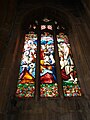
 All Saints Parish Church, Westbury - geograph.org.uk - 4070728.jpg 800 × 689; 153 KB
-
 All Saints, Westbury, altar (1) - geograph.org.uk - 5089094.jpg 640 × 480; 55 KB
-
 All Saints, Westbury, altar (2) - geograph.org.uk - 5089095.jpg 640 × 480; 62 KB
-
 All Saints, Westbury, altar (3) - geograph.org.uk - 5089098.jpg 640 × 480; 65 KB
-

-

-

-

-
 All Saints, Westbury, churchyard (V) - geograph.org.uk - 5089061.jpg 640 × 480; 58 KB
-
-
 All Saints, Westbury, font - geograph.org.uk - 5089093.jpg 640 × 480; 52 KB
-

-

-
 All Saints, Westbury, memorial (1) - geograph.org.uk - 5089101.jpg 640 × 480; 54 KB
-
 All Saints, Westbury, memorial (10) - geograph.org.uk - 5089111.jpg 640 × 480; 57 KB
-
 All Saints, Westbury, memorial (11) - geograph.org.uk - 5089113.jpg 640 × 480; 64 KB
-
 All Saints, Westbury, memorial (12) - geograph.org.uk - 5089115.jpg 640 × 480; 44 KB
-
 All Saints, Westbury, memorial (13) - geograph.org.uk - 5089118.jpg 640 × 480; 68 KB
-
 All Saints, Westbury, memorial (14) - geograph.org.uk - 5089120.jpg 480 × 640; 53 KB
-
 All Saints, Westbury, memorial (15) - geograph.org.uk - 5089123.jpg 640 × 480; 76 KB
-
 All Saints, Westbury, memorial (16) - geograph.org.uk - 5089125.jpg 480 × 640; 46 KB
-
 All Saints, Westbury, memorial (17) - geograph.org.uk - 5089129.jpg 640 × 480; 68 KB
-
 All Saints, Westbury, memorial (18) - geograph.org.uk - 5089130.jpg 480 × 640; 56 KB
-
 All Saints, Westbury, memorial (19) - geograph.org.uk - 5089132.jpg 640 × 480; 72 KB
-
 All Saints, Westbury, memorial (2) - geograph.org.uk - 5089100.jpg 640 × 480; 64 KB
-
 All Saints, Westbury, memorial (20) - geograph.org.uk - 5089127.jpg 640 × 480; 54 KB
-
 All Saints, Westbury, memorial (21) - geograph.org.uk - 5089133.jpg 640 × 480; 73 KB
-
 All Saints, Westbury, memorial (22) - geograph.org.uk - 5089135.jpg 480 × 640; 62 KB
-
 All Saints, Westbury, memorial (23) - geograph.org.uk - 5089137.jpg 480 × 640; 45 KB
-
 All Saints, Westbury, memorial (3) - geograph.org.uk - 5089102.jpg 640 × 480; 50 KB
-
 All Saints, Westbury, memorial (4) - geograph.org.uk - 5089104.jpg 480 × 640; 42 KB
-
 All Saints, Westbury, memorial (5) - geograph.org.uk - 5089105.jpg 640 × 480; 54 KB
-
 All Saints, Westbury, memorial (6) - geograph.org.uk - 5089106.jpg 640 × 480; 51 KB
-
 All Saints, Westbury, memorial (7) - geograph.org.uk - 5089107.jpg 480 × 640; 52 KB
-
 All Saints, Westbury, memorial (8) - geograph.org.uk - 5089108.jpg 640 × 480; 94 KB
-
 All Saints, Westbury, memorial (9) - geograph.org.uk - 5089110.jpg 480 × 640; 70 KB
-

-
 All Saints, Westbury, organ - geograph.org.uk - 5089099.jpg 480 × 640; 61 KB
-
 All Saints, Westbury, pulpit (i) - geograph.org.uk - 5089073.jpg 640 × 480; 83 KB
-
 All Saints, Westbury, pulpit (ii) - geograph.org.uk - 5089075.jpg 640 × 480; 71 KB
-
 All Saints, Westbury, south door - geograph.org.uk - 5089092.jpg 640 × 480; 63 KB
-

-

-

-

-

-

-

-

-

-

-

-
-

-

-
-

-
 Aston Barclay - geograph.org.uk - 4875971.jpg 640 × 426; 89 KB
-
 Aston Barclay - geograph.org.uk - 5665032.jpg 640 × 426; 57 KB
-
 Aston Barclay - geograph.org.uk - 5665033.jpg 640 × 425; 58 KB
-
 Aston Barclay Westbury - geograph.org.uk - 5911383.jpg 1,024 × 666; 138 KB
-
 Aston Barclay. Westbury - geograph.org.uk - 4623096.jpg 640 × 426; 58 KB
-
 Attractions in Westbury - geograph.org.uk - 3905286.jpg 800 × 656; 177 KB
-
 Autoexcel Vehicle Services, Brook Lane, Westbury - geograph.org.uk - 5911373.jpg 1,024 × 641; 122 KB
-
 B3097 - geograph.org.uk - 5386104.jpg 640 × 426; 48 KB
-
 B3097 - geograph.org.uk - 5560367.jpg 640 × 426; 80 KB
-
 B3097 - geograph.org.uk - 5964217.jpg 1,024 × 495; 104 KB
-
 B3097 at Westbury - geograph.org.uk - 4770110.jpg 1,920 × 1,162; 530 KB
-
 B3098 near Westbury - geograph.org.uk - 3389871.jpg 4,320 × 3,240; 4.96 MB
-
 Benchmark on All Saints Church - geograph.org.uk - 3176156.jpg 683 × 1,024; 323 KB
-
 Benchmark on All Saints Church - geograph.org.uk - 3176189.jpg 683 × 1,024; 353 KB
-
 Benchmark on garage in front of ^74 Newtown - geograph.org.uk - 3176530.jpg 1,024 × 683; 233 KB
-
 Benchmark on the Horse and Groom pub - geograph.org.uk - 3176397.jpg 1,024 × 683; 344 KB
-
 Benchmark on the Public Baths, Church Street - geograph.org.uk - 3176123.jpg 683 × 1,024; 255 KB
-
 Benchmark on ^1 Warminster Road - geograph.org.uk - 3176061.jpg 683 × 1,024; 198 KB
-
 Benchmark on ^31 Haynes Road - geograph.org.uk - 3175945.jpg 683 × 1,024; 270 KB
-
 Benchmark on ^38 Newtown - geograph.org.uk - 3176507.jpg 683 × 1,024; 229 KB
-
 Benchmark on ^98 Leigh Road - geograph.org.uk - 3176687.jpg 683 × 1,024; 246 KB
-
 Benchmarked milestone in wall of Leigh Road - geograph.org.uk - 3176634.jpg 683 × 1,024; 283 KB
-
 Bend in Stephenson Road, Westbury - geograph.org.uk - 5911437.jpg 1,024 × 758; 187 KB
-
 Biss Brook, Brook Farm, Westbury - geograph.org.uk - 889207.jpg 640 × 480; 165 KB
-
 Bitham Brook - geograph.org.uk - 3866192.jpg 1,704 × 2,304; 2.39 MB
-
 Black Dog Woods, Dilton Marsh - geograph.org.uk - 817922.jpg 640 × 480; 234 KB
-
 Blue cars, blue sign, blue sky - geograph.org.uk - 131253.jpg 480 × 640; 50 KB
-

-
 Bratten Road - geograph.org.uk - 3624457.jpg 640 × 427; 64 KB
-
 Bratton Road - geograph.org.uk - 3623364.jpg 640 × 427; 71 KB
-
 Bratton Road, Westbury - geograph.org.uk - 5007995.jpg 4,000 × 3,000; 3.65 MB
-

-
 Bridge House, Station Road - geograph.org.uk - 3796010.jpg 4,000 × 3,000; 2.78 MB
-
 Bridge House, Westbury - geograph.org.uk - 3879400.jpg 800 × 651; 136 KB
-
 Bridge over A350 near Leighton House - geograph.org.uk - 5446258.jpg 1,600 × 1,067; 707 KB
-
 Brook House, Westbury - geograph.org.uk - 2858273.jpg 640 × 451; 77 KB
-

-
 Brook Lane traffic calming, Westbury - geograph.org.uk - 5911428.jpg 961 × 1,024; 299 KB
-
 Business units at Madbrook Farm - geograph.org.uk - 5446259.jpg 1,600 × 1,201; 649 KB
-
 Buttressed house at junction of B3098 and A350, Westbury - geograph.org.uk - 5446254.jpg 1,600 × 1,202; 818 KB
-
 Car park on Warminster Road, Westbury - geograph.org.uk - 5770306.jpg 2,032 × 1,514; 1.39 MB
-
 Cedar Hotel and Restaurant. - geograph.org.uk - 1919228.jpg 640 × 442; 62 KB
-
 Cement works chimney near Bratton - geograph.org.uk - 3389850.jpg 4,320 × 3,240; 3.89 MB
-
 Cement works near Westbury - geograph.org.uk - 4779372.jpg 3,264 × 2,448; 3.59 MB
-
 Cement works ^ chimney - geograph.org.uk - 4628427.jpg 640 × 426; 49 KB
-
 Cement Works, Westbury - geograph.org.uk - 2012350.jpg 640 × 476; 153 KB
-
 Charlies Bar and The Crown Inn, Westbury - geograph.org.uk - 3877416.jpg 800 × 719; 145 KB
-
 Checkers Baguette Shop, Westbury - geograph.org.uk - 4115502.jpg 800 × 740; 137 KB
-
 Church Path, Westbury - geograph.org.uk - 899017.jpg 640 × 480; 202 KB
-
 Club 24 Fitness, Station Road, Westbury - geograph.org.uk - 5911334.jpg 1,024 × 753; 187 KB
-
 Co-Op Funerals in Warminster Road - geograph.org.uk - 5089049.jpg 640 × 480; 73 KB
-
 Coach Road railway bridge - geograph.org.uk - 899106.jpg 640 × 480; 112 KB
-
 Collectable Times in Westbury - geograph.org.uk - 3877377.jpg 769 × 800; 139 KB
-

-
 Coniston Lake (NBY 438469).jpg 3,600 × 2,355; 940 KB
-
 Cow pasture behind Overcourt Farm - geograph.org.uk - 841598.jpg 640 × 454; 85 KB
-
 Cowards Farm - geograph.org.uk - 792866.jpg 640 × 426; 106 KB
-
 Criollo Court, Westbury - geograph.org.uk - 3905400.jpg 800 × 611; 109 KB
-
 Dairy Farm at Fairwood - geograph.org.uk - 818432.jpg 640 × 491; 94 KB
-
 Dairy Farm, Fairwood - geograph.org.uk - 807345.jpg 640 × 430; 79 KB
-
 Davies of Westbury - geograph.org.uk - 4070672.jpg 800 × 592; 124 KB
-
 DB Schenker sidings - geograph.org.uk - 3795432.jpg 4,000 × 3,000; 2.59 MB
-
 DB Schenker train, Westbury - geograph.org.uk - 5033857.jpg 640 × 426; 42 KB
-
 DB Schenker Train, Westbury Sidings - geograph.org.uk - 4942769.jpg 640 × 426; 48 KB
-
 Detail of the Laverton - geograph.org.uk - 3865347.jpg 2,304 × 1,704; 1.57 MB
-
 Dilton Vale in Winter - December 2010 - panoramio.jpg 3,072 × 1,607; 1.06 MB
-

-
 Disused stile - geograph.org.uk - 130150.jpg 640 × 480; 134 KB
-
 Do Not Feed the Horses - geograph.org.uk - 4482292.jpg 640 × 480; 78 KB
-
 Dressage area - geograph.org.uk - 5560444.jpg 640 × 426; 78 KB
-
 Edward Street elegance - geograph.org.uk - 3866131.jpg 1,704 × 2,304; 1.41 MB
-
 Edward Street, Westbury - geograph.org.uk - 3877454.jpg 800 × 644; 136 KB
-

-
 Empty shop in Edward Street, Westbury - geograph.org.uk - 3882631.jpg 800 × 613; 129 KB
-
-

-
 Esso filling station, A350, Westbury - geograph.org.uk - 5446255.jpg 1,600 × 1,279; 713 KB
-
 Esso garage on Warminster Road, Westbury - geograph.org.uk - 5770305.jpg 2,048 × 1,536; 1.63 MB
-
 EWS diesel shunter in Westbury - geograph.org.uk - 3896093.jpg 800 × 667; 172 KB
-
 EWS Train, Westbury Sidings - geograph.org.uk - 5033855.jpg 640 × 426; 52 KB
-
 Farmland at Brook Farm - geograph.org.uk - 856011.jpg 640 × 472; 91 KB
-
 Farmland below The White Horse - geograph.org.uk - 5030931.jpg 640 × 426; 35 KB
-
 Farmland near Heywood Road Junction - geograph.org.uk - 5665024.jpg 640 × 426; 43 KB
-
 Farmland near Westbury - geograph.org.uk - 5117676.jpg 640 × 426; 45 KB
-
 Field by Heywood Road junction - geograph.org.uk - 5193073.jpg 640 × 426; 37 KB
-
 Field by Heywood Road Junction - geograph.org.uk - 5560451.jpg 640 × 426; 56 KB
-
 Field edge by the White Horse viewpoint car park - geograph.org.uk - 5925761.jpg 1,024 × 683; 211 KB
-
 Field near Heywood Road Junction - geograph.org.uk - 4623394.jpg 640 × 426; 62 KB
-
 Field near Heywood Road Junction - geograph.org.uk - 5665018.jpg 640 × 426; 63 KB
-
 Field near Heywood Road Junction - geograph.org.uk - 5665025.jpg 640 × 426; 58 KB
-
 First Great Western Train, Westbury - geograph.org.uk - 4623079.jpg 640 × 426; 54 KB
-
 Footpath alongside Bitham Brook - geograph.org.uk - 130141.jpg 640 × 480; 116 KB
-
 Footpath alongside Bitham Brook. - geograph.org.uk - 130142.jpg 640 × 480; 118 KB
-
 Footpath down Bitham Lane - geograph.org.uk - 3866184.jpg 1,704 × 2,304; 2 MB
-
 Footpath to Castle View. - geograph.org.uk - 129540.jpg 640 × 480; 63 KB
-
 Fore Street, Westbury - geograph.org.uk - 3089951.jpg 3,443 × 2,371; 1.43 MB
-

-
 Former Cement works - geograph.org.uk - 5560456.jpg 640 × 426; 72 KB
-
 Former Eastleigh Surgery, Westbury - geograph.org.uk - 4070788.jpg 800 × 508; 113 KB
-
 Former friends - geograph.org.uk - 3865366.jpg 1,704 × 2,304; 1.71 MB
-
 Former shop on Warminster Road, Westbury - geograph.org.uk - 5925753.jpg 1,024 × 683; 169 KB
-

-
 Freight, Westbury Sidings - geograph.org.uk - 4867109.jpg 640 × 426; 74 KB
-
 Freight, Westbury Sidings - geograph.org.uk - 4867111.jpg 640 × 426; 58 KB
-
 Freight, Westbury Sidings - geograph.org.uk - 4867113.jpg 640 × 426; 41 KB
-
 Frogmore Road lake, Westbury - geograph.org.uk - 869779.jpg 640 × 480; 136 KB
-
 Frogmore Road, Westbury - geograph.org.uk - 869783.jpg 640 × 480; 145 KB
-
 Garden Railway - geograph.org.uk - 128969.jpg 640 × 480; 149 KB
-
 Garden visitor - geograph.org.uk - 105093.jpg 640 × 480; 153 KB
-
 Gate on footpath - geograph.org.uk - 3795098.jpg 4,000 × 3,000; 4.62 MB
-

-
 Gloucester Walk entrance, Westbury - geograph.org.uk - 1052300.jpg 640 × 480; 132 KB
-
 Gooselands mini-roundabout, Westbury - geograph.org.uk - 4201305.jpg 800 × 518; 107 KB
-
 Gooselands, Westbury - geograph.org.uk - 4201311.jpg 800 × 582; 138 KB
-
 Grassy bank on Warminster Road - geograph.org.uk - 5770304.jpg 1,708 × 1,223; 1.37 MB
-
 Grazing land near Westbury - geograph.org.uk - 4876003.jpg 640 × 426; 58 KB
-
 Green Lane, Westbury - geograph.org.uk - 3882181.jpg 800 × 610; 150 KB
-
 GWRSA Westbury Branch - geograph.org.uk - 3882072.jpg 800 × 631; 115 KB
-
 Ham Stores and post office near Westbury - geograph.org.uk - 5911303.jpg 1,024 × 648; 152 KB
-
 Hang gliders above the Westbury White Horse - geograph.org.uk - 5925765.jpg 1,024 × 683; 106 KB
-
 Hang-Gliding At Westbury Hill - geograph.org.uk - 5872955.jpg 515 × 640; 99 KB
-
 Heywood Road Junction - geograph.org.uk - 4543580.jpg 1,600 × 1,200; 381 KB
-

-
 Hills recycling site, Westbury - geograph.org.uk - 5911458.jpg 1,024 × 707; 157 KB
-
 Hillside below the Westbury White Horse - geograph.org.uk - 5925773.jpg 1,024 × 683; 174 KB
-
 Holme Oak - geograph.org.uk - 133658.jpg 480 × 640; 117 KB


_-_geograph.org.uk_-_5089094.jpg)
_-_geograph.org.uk_-_5089095.jpg)
_-_geograph.org.uk_-_5089098.jpg)

_-_geograph.org.uk_-_5089058.jpg)
_-_geograph.org.uk_-_5089059.jpg)
_-_geograph.org.uk_-_5089060.jpg)
_-_geograph.org.uk_-_5089061.jpg)
_-_geograph.org.uk_-_5089062.jpg)

_-_geograph.org.uk_-_5089140.jpg)
_-_geograph.org.uk_-_5089139.jpg)
_-_geograph.org.uk_-_5089101.jpg)
_-_geograph.org.uk_-_5089111.jpg)
_-_geograph.org.uk_-_5089113.jpg)
_-_geograph.org.uk_-_5089115.jpg)
_-_geograph.org.uk_-_5089118.jpg)
_-_geograph.org.uk_-_5089120.jpg)
_-_geograph.org.uk_-_5089123.jpg)
_-_geograph.org.uk_-_5089125.jpg)
_-_geograph.org.uk_-_5089129.jpg)
_-_geograph.org.uk_-_5089130.jpg)
_-_geograph.org.uk_-_5089132.jpg)
_-_geograph.org.uk_-_5089100.jpg)
_-_geograph.org.uk_-_5089127.jpg)
_-_geograph.org.uk_-_5089133.jpg)
_-_geograph.org.uk_-_5089135.jpg)
_-_geograph.org.uk_-_5089137.jpg)
_-_geograph.org.uk_-_5089102.jpg)
_-_geograph.org.uk_-_5089104.jpg)
_-_geograph.org.uk_-_5089105.jpg)
_-_geograph.org.uk_-_5089106.jpg)
_-_geograph.org.uk_-_5089107.jpg)
_-_geograph.org.uk_-_5089108.jpg)
_-_geograph.org.uk_-_5089110.jpg)


_-_geograph.org.uk_-_5089073.jpg)
_-_geograph.org.uk_-_5089075.jpg)

_-_geograph.org.uk_-_5089141.jpg)
_-_geograph.org.uk_-_5089152.jpg)
_-_geograph.org.uk_-_5089153.jpg)
_-_geograph.org.uk_-_5089156.jpg)
_-_geograph.org.uk_-_5089155.jpg)
_-_geograph.org.uk_-_5089158.jpg)
_-_geograph.org.uk_-_5089142.jpg)
_-_geograph.org.uk_-_5089143.jpg)
_-_geograph.org.uk_-_5089145.jpg)
_-_geograph.org.uk_-_5089146.jpg)
_-_geograph.org.uk_-_5089147.jpg)
_-_geograph.org.uk_-_5089148.jpg)
_-_geograph.org.uk_-_5089149.jpg)
_-_geograph.org.uk_-_5089151.jpg)


.jpg)


