Category:Westwick, Norfolk
Jump to navigation
Jump to search
English: Westwick is a village and civil parish in the English county of Norfolk, situated to the south of North Walsham.
village and civil parish in Norfolk, United Kingdom  | |||||
| Upload media | |||||
| Instance of | |||||
|---|---|---|---|---|---|
| Location | North Norfolk, Norfolk, East of England, England | ||||
| Area |
| ||||
 | |||||
Subcategories
This category has the following 10 subcategories, out of 10 total.
B
- Benches in Westwick, Norfolk (3 F)
- Buildings in Westwick, Norfolk (14 F)
E
F
- Footpaths in Westwick, Norfolk (16 F)
H
- Westwick House, Norfolk (2 F)
N
S
V
Media in category "Westwick, Norfolk"
The following 89 files are in this category, out of 89 total.
-
 A large cultivated field - geograph.org.uk - 943962.jpg 640 × 463; 169 KB
-
 A sluice in the woods - without water - geograph.org.uk - 1080938.jpg 640 × 480; 158 KB
-
 Arch Cottages, Westwick - geograph.org.uk - 4287841.jpg 640 × 480; 154 KB
-
 B1150 towards North Walsham - geograph.org.uk - 5877293.jpg 1,024 × 684; 341 KB
-
 B1150 towards North Walsham - geograph.org.uk - 5877296.jpg 1,024 × 684; 347 KB
-
 B1150 towards North Walsham - geograph.org.uk - 5877297.jpg 1,024 × 684; 263 KB
-
 Captain's Pond - geograph.org.uk - 3114274.jpg 640 × 480; 101 KB
-
 Farm bridge over drain - geograph.org.uk - 1099941.jpg 640 × 480; 156 KB
-
 Field adjoining public footpath - geograph.org.uk - 1297835.jpg 640 × 480; 113 KB
-
 Field beside Swanton Abbott Road - geograph.org.uk - 1028407.jpg 640 × 480; 94 KB
-
 Footbridge crossing drain - geograph.org.uk - 1080815.jpg 640 × 480; 139 KB
-
 Gated level crossing - geograph.org.uk - 458428.jpg 640 × 480; 84 KB
-
 Green crops beside the road - geograph.org.uk - 943975.jpg 640 × 469; 180 KB
-
 Green Lodge, The Hill - geograph.org.uk - 5966720.jpg 1,600 × 1,064; 807 KB
-

-
 Harvested and cultivated - geograph.org.uk - 944006.jpg 640 × 480; 131 KB
-
 Holly Plantation - geograph.org.uk - 943954.jpg 640 × 401; 139 KB
-
 Leathercoat Lane - geograph.org.uk - 944011.jpg 480 × 640; 196 KB
-
 Maize field adjoining Heath Plantation - geograph.org.uk - 1027030.jpg 640 × 509; 151 KB
-
 Meadow beside The Hill - geograph.org.uk - 3966924.jpg 480 × 640; 220 KB
-
 Meadow beside the track - geograph.org.uk - 1080752.jpg 640 × 480; 100 KB
-
 Meadow beside the track - geograph.org.uk - 1099874.jpg 640 × 480; 152 KB
-
 Meadows beside The Hill - geograph.org.uk - 3966925.jpg 640 × 440; 143 KB
-
 Minor road near Sloley - geograph.org.uk - 5365298.jpg 1,600 × 1,200; 589 KB
-
 Obelisk in Obelisk Grove - geograph.org.uk - 458318.jpg 480 × 640; 112 KB
-
 Old milestone - geograph.org.uk - 786026.jpg 480 × 640; 166 KB
-
 Old trees growing by The Hill - geograph.org.uk - 3966920.jpg 640 × 480; 272 KB
-

-
 Path to Long Common Lane - geograph.org.uk - 1080786.jpg 640 × 480; 125 KB
-
 Perch Lake Plantation - geograph.org.uk - 1028241.jpg 640 × 637; 187 KB
-
 Plank bridge over drain - geograph.org.uk - 1080908.jpg 480 × 640; 153 KB
-

-

-
 Remains of a felled tree - geograph.org.uk - 1080793.jpg 640 × 480; 145 KB
-
 Restricted Byway sign and pathway - geograph.org.uk - 4287796.jpg 640 × 480; 194 KB
-
 Sluice and engine house - geograph.org.uk - 1080930.jpg 640 × 480; 171 KB
-

-
 Sunshine and showers - geograph.org.uk - 786034.jpg 480 × 640; 189 KB
-
 The Hill at School Road - geograph.org.uk - 5966733.jpg 1,600 × 1,064; 890 KB
-
 The Hill, Westwick - geograph.org.uk - 451830.jpg 640 × 480; 60 KB
-
 The Hill, Westwick - geograph.org.uk - 451838.jpg 480 × 640; 81 KB
-
 The Hill, Westwick - geograph.org.uk - 451846.jpg 480 × 640; 132 KB
-
 The Hill, Westwick - geograph.org.uk - 457588.jpg 640 × 480; 91 KB
-
 The Hill, Westwick - geograph.org.uk - 457590.jpg 640 × 480; 96 KB
-
 The Hill, Westwick - geograph.org.uk - 457596.jpg 640 × 480; 100 KB
-
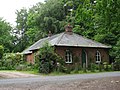
 The Old School, School Road, Westwick - geograph.org.uk - 4287816.jpg 640 × 480; 203 KB
-

-
 The plaque on the old school at Westwick - geograph.org.uk - 4287830.jpg 640 × 480; 177 KB
-
 The road past Captains Pond, Westwick - geograph.org.uk - 4287807.jpg 640 × 480; 161 KB
-

-
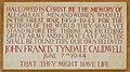
 The WW1 Memorial at Westwick - geograph.org.uk - 6197006.jpg 2,280 × 1,860; 1.12 MB
-
 This way to the B1150 road - geograph.org.uk - 3966803.jpg 640 × 480; 132 KB
-
 Track into Westwick estate - geograph.org.uk - 786013.jpg 480 × 640; 154 KB
-
 Track to Lord Anson's Wood - geograph.org.uk - 1027038.jpg 638 × 613; 197 KB
-
 Tractor tyre marks - geograph.org.uk - 943987.jpg 480 × 640; 188 KB
-
 Trees growing alongside a drain - geograph.org.uk - 1080821.jpg 640 × 480; 118 KB
-
 Uncultivated field - geograph.org.uk - 1080853.jpg 640 × 480; 124 KB
-
 Unnamed Road past Brook Farm - geograph.org.uk - 944021.jpg 640 × 480; 111 KB
-
 View across field towards Holly Farm - geograph.org.uk - 522220.jpg 640 × 480; 94 KB
-
 View across fields - geograph.org.uk - 1080887.jpg 640 × 480; 104 KB
-
 View east along a farm track - geograph.org.uk - 1027041.jpg 640 × 525; 115 KB
-
 View NE to Waterloo Plantation - geograph.org.uk - 944013.jpg 480 × 640; 137 KB
-
 View north along Leathercoat Lane - geograph.org.uk - 1080742.jpg 480 × 640; 119 KB
-
 View north along Leathercoat Lane - geograph.org.uk - 1080897.jpg 640 × 480; 129 KB
-
 View through a hedge - geograph.org.uk - 522222.jpg 640 × 480; 101 KB
-
 View towards Mill Hill - geograph.org.uk - 3966921.jpg 640 × 480; 167 KB
-
 View towards Waterloo Plantation - geograph.org.uk - 3966804.jpg 640 × 480; 129 KB
-
 Viper's bugloss (Echinum vulgare) - geograph.org.uk - 1297831.jpg 543 × 640; 190 KB
-
 Waterfilled hole in the ground - geograph.org.uk - 1080962.jpg 480 × 640; 172 KB
-
 Waterloo Plantation - geograph.org.uk - 1080902.jpg 640 × 480; 86 KB
-
 Westwick House - geograph.org.uk - 4287853.jpg 640 × 480; 121 KB
-
 Westwick House Estate, Norfolk - geograph.org.uk - 1959743.jpg 640 × 480; 77 KB
-
 Westwick St Botolph's church - geograph.org.uk - 2209980.jpg 640 × 480; 191 KB
-
 Westwick village sign - geograph.org.uk - 4287836.jpg 480 × 640; 199 KB
-
 A broken fence - geograph.org.uk - 1080827.jpg 640 × 480; 93 KB
-
 Wheat crop by Brook Farm - geograph.org.uk - 3966801.jpg 640 × 480; 172 KB
-
 Where to^ - geograph.org.uk - 529118.jpg 640 × 480; 79 KB
-
 Wire mesh fence in meadow - geograph.org.uk - 1080811.jpg 640 × 480; 97 KB
-
 Woodland beside the B1150 (Norwich Road) - geograph.org.uk - 617177.jpg 480 × 640; 123 KB
-
 Woodland path - geograph.org.uk - 1080916.jpg 640 × 480; 154 KB
-
 WW2 Memorial at Westwick - geograph.org.uk - 6197021.jpg 2,841 × 1,590; 1.32 MB
-

-

-

-
-

-
 A view of Westwick Park - geograph.org.uk - 617204.jpg 640 × 480; 52 KB
-
 A wet meadow - geograph.org.uk - 1080789.jpg 640 × 480; 96 KB
-
 At the edge of the wood - geograph.org.uk - 617190.jpg 480 × 640; 108 KB


_-_geograph.org.uk_-_1297831.jpg)


_-_geograph.org.uk_-_617177.jpg)


