Category:Whittington, Lichfield
Jump to navigation
Jump to search
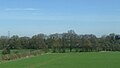
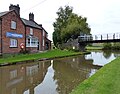
English: Whittington is a village and civil parish which lies approximately 3 miles south east of Lichfield in the Lichfield district of Staffordshire, England. According to the 2001 census it had a population of 2,591. The parish council is a joint one with Fisherwick. The Coventry Canal borders the village to the north and east.
village and civil parish in Lichfield District, Staffordshire, United Kingdom  | |||||
| Upload media | |||||
| Instance of | |||||
|---|---|---|---|---|---|
| Location | Lichfield, Staffordshire, West Midlands, England | ||||
| Said to be the same as | Whittington (Wikimedia duplicated page, civil parish) | ||||
 | |||||
Subcategories
This category has the following 5 subcategories, out of 5 total.
O
- Whittington Old Hall (1 F)
W
- Whittington Barracks (2 F)
- Whittington Lock (3 F)
Media in category "Whittington, Lichfield"
The following 200 files are in this category, out of 262 total.
(previous page) (next page)-
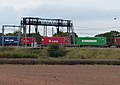
 "4 tracking" - rail engineering works - geograph.org.uk - 298357.jpg 640 × 480; 95 KB
-
 A boggy field near Whittington - geograph.org.uk - 2830027.jpg 640 × 430; 43 KB
-

-

-
 A38 southbound near Lichfield - geograph.org.uk - 2403105.jpg 640 × 349; 39 KB
-
 A51 at The Whittington Arms - geograph.org.uk - 2725839.jpg 640 × 480; 77 KB
-
 A51 at Whittington Barracks - geograph.org.uk - 2725827.jpg 640 × 480; 74 KB
-
 A51 nearing Lichfield - geograph.org.uk - 2725891.jpg 640 × 480; 60 KB
-

-
 Beagles Whittington Common Road Whittington Staffordshire.jpg 800 × 495; 130 KB
-
 Birmingham and Fazeley Canal near Whittington, Staffordshire - geograph.org.uk - 3115124.jpg 1,440 × 1,019; 1.62 MB
-

-
 Bowmans Bridge No 82 - geograph.org.uk - 4706029.jpg 800 × 625; 197 KB
-
 Bridge 79, Coventry Canal - geograph.org.uk - 5168935.jpg 1,280 × 851; 454 KB
-
 Bridge Farm - geograph.org.uk - 2830019.jpg 640 × 430; 45 KB
-
 Bridge Farm - geograph.org.uk - 3657892.jpg 640 × 318; 29 KB
-
 Bridge No 79 at Whittington in Staffordshire - geograph.org.uk - 5701719.jpg 1,280 × 960; 1.66 MB
-
 Bridge No 79 at Whittington in Staffordshire - geograph.org.uk - 5703371.jpg 1,280 × 927; 1.34 MB
-

-

-

-
-
 Bridleway gate near Whittington, Staffordshire - geograph.org.uk - 6253221.jpg 960 × 1,280; 1.85 MB
-
 Bridleway near Huddlesford in Staffordshire - geograph.org.uk - 6252725.jpg 1,280 × 960; 1.64 MB
-
 Bridleway near Huddlesford in Staffordshire - geograph.org.uk - 6253119.jpg 1,080 × 1,440; 2.02 MB
-

-
 Bridleway south-west of Huddlesford in Staffordshire - geograph.org.uk - 6254134.jpg 960 × 1,280; 1.61 MB
-
 Burton Road approaching Whittington in Staffordshire - geograph.org.uk - 5702000.jpg 1,280 × 883; 1.38 MB
-
 Burton Road north of Whittington in Staffordshire - geograph.org.uk - 5702018.jpg 1,280 × 960; 1.55 MB
-
 Burton Road, Whittington - geograph.org.uk - 5179996.jpg 1,280 × 851; 418 KB
-

-
 Canal approaching Whittington in Staffordshire - geograph.org.uk - 6249671.jpg 1,440 × 960; 1.51 MB
-

-
 Canal at Bowman's Bridge near Huddlesford, Staffordshire - geograph.org.uk - 6250498.jpg 1,440 × 1,080; 1.9 MB
-
 Canal cruising near Huddlesford in Staffordshire - geograph.org.uk - 6252538.jpg 1,280 × 960; 1.89 MB
-
 Canal footbridge at Huddlesford Junction, Staffordshire - geograph.org.uk - 6250927.jpg 1,440 × 1,080; 1.64 MB
-

-
 Canalside housing in Whittington, Staffordshire - geograph.org.uk - 6165625.jpg 1,440 × 960; 1.68 MB
-

-

-
 Capper's Lane west of Whittington in Staffordshire - geograph.org.uk - 6253328.jpg 1,440 × 960; 1.58 MB
-

-
 Cattle sheds near Huddlesford in Staffordshire - geograph.org.uk - 6252570.jpg 1,600 × 900; 1.27 MB
-
-

-

-

-
 Common Lane in Whittington - geograph.org.uk - 4701440.jpg 800 × 600; 179 KB
-

-

-
 Coventry Canal - geograph.org.uk - 433045.jpg 640 × 480; 61 KB
-
 Coventry Canal - geograph.org.uk - 433056.jpg 640 × 480; 103 KB
-
 Coventry Canal - geograph.org.uk - 4369684.jpg 640 × 430; 50 KB
-
 Coventry Canal - geograph.org.uk - 6130843.jpg 640 × 480; 41 KB
-

-
 Coventry Canal at Huddlesford in Staffordshire - geograph.org.uk - 5700907.jpg 1,280 × 816; 1.38 MB
-
 Coventry Canal at Huddlesford in Staffordshire - geograph.org.uk - 6251318.jpg 1,440 × 1,080; 1.5 MB
-
 Coventry Canal at Huddlesford in Staffordshire - geograph.org.uk - 6251328.jpg 1,440 × 960; 1.44 MB
-
 Coventry Canal at Huddlesford in Staffordshire - geograph.org.uk - 6251339.jpg 1,440 × 960; 1.39 MB
-
 Coventry Canal at Huddlesford, Staffordshire - geograph.org.uk - 1933133.jpg 1,280 × 946; 1.12 MB
-
 Coventry Canal at Whittington - geograph.org.uk - 4706095.jpg 800 × 603; 154 KB
-
 Coventry Canal in Whittington, Staffordshire - geograph.org.uk - 6165629.jpg 1,280 × 960; 1.77 MB
-

-
 Coventry Canal moorings near Huddlesford in Staffordshire - geograph.org.uk - 6250909.jpg 1,440 × 1,080; 2.07 MB
-
 Coventry Canal near Huddlesford in Staffordshire - geograph.org.uk - 6165634.jpg 1,440 × 960; 1.22 MB
-
 Coventry Canal near Huddlesford in Staffordshire - geograph.org.uk - 6250505.jpg 1,600 × 900; 2.1 MB
-
 Coventry Canal near Huddlesford in Staffordshire - geograph.org.uk - 6250507.jpg 1,440 × 960; 1.98 MB
-
 Coventry Canal near Whittington in Staffordshire - geograph.org.uk - 6165623.jpg 1,600 × 900; 1.94 MB
-
 Coventry Canal near Whittington in Staffordshire - geograph.org.uk - 6250357.jpg 1,280 × 960; 1.74 MB
-
 Coventry Canal near Whittington in Staffordshire - geograph.org.uk - 6250360.jpg 1,280 × 960; 1.79 MB
-
 Coventry Canal north of Huddlesford Junction - geograph.org.uk - 6251445.jpg 1,440 × 960; 1.4 MB
-

-

-

-
-
 Coventry Canal, Whittington - geograph.org.uk - 5168906.jpg 1,280 × 851; 420 KB
-
 Coventry Canal, Whittington - geograph.org.uk - 5168946.jpg 1,280 × 851; 376 KB
-

-

-
 Crop field near Huddlesford - geograph.org.uk - 5334126.jpg 640 × 361; 34 KB
-
 Darnford Lane - geograph.org.uk - 443465.jpg 640 × 480; 86 KB
-
 Darnford Lane crossing the A38 - geograph.org.uk - 4701558.jpg 800 × 512; 106 KB
-
 Darnford Lane Towards Whittington - geograph.org.uk - 2487330.jpg 640 × 428; 117 KB
-

-
 End of the day near Huddlesford in Staffordshire - geograph.org.uk - 6164110.jpg 960 × 1,280; 850 KB
-
 End of the day near Huddlesford in Staffordshire - geograph.org.uk - 6164116.jpg 1,280 × 960; 961 KB
-
 Entrance to the Farm, Williford - geograph.org.uk - 2507018.jpg 640 × 428; 118 KB
-
 Evening freight at Huddlesford, 1984 - geograph.org.uk - 2276553.jpg 640 × 428; 66 KB
-
 Farm buildings by Huddlesford Lane in Staffordshire - geograph.org.uk - 6252557.jpg 1,600 × 900; 1.34 MB
-

-
 Farmland and trees - geograph.org.uk - 4894858.jpg 640 × 426; 58 KB
-
 Farmland and woodland - geograph.org.uk - 3657889.jpg 640 × 341; 30 KB
-
 Farmland at Whittington Heath - geograph.org.uk - 4701380.jpg 800 × 600; 153 KB
-

-
 Farmland by Fisherwick Brook - geograph.org.uk - 3850853.jpg 640 × 430; 64 KB
-

-
 Farmland by the railway line - geograph.org.uk - 3850867.jpg 640 × 430; 55 KB
-
 Farmland near Bridge Farm - geograph.org.uk - 4894852.jpg 640 × 313; 35 KB
-
 Farmland near Huddlesford - geograph.org.uk - 3850879.jpg 640 × 430; 54 KB
-
 Farmland near Huddlesford - geograph.org.uk - 4894848.jpg 640 × 426; 43 KB
-
 Farmland near Huddlesford in Staffordshire - geograph.org.uk - 6252578.jpg 1,280 × 960; 1.4 MB
-
 Farmland north-west of Whittington in Staffordshire - geograph.org.uk - 6254199.jpg 1,440 × 960; 1.55 MB
-
 Farmland north-west of Whittington, Staffordshire - geograph.org.uk - 3115163.jpg 1,600 × 1,023; 1.57 MB
-
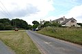
 Farmland on the edge of Whittington - geograph.org.uk - 4701490.jpg 800 × 623; 120 KB
-
-
 Farmland south-east of Huddlesford in Staffordshire - geograph.org.uk - 6250484.jpg 1,440 × 1,080; 1.83 MB
-
 Farmland, Huddlesford - geograph.org.uk - 2830017.jpg 640 × 430; 36 KB
-
 Farmland, Huddlesford - geograph.org.uk - 3657896.jpg 640 × 359; 31 KB
-
 Farmland, Huddlesford - geograph.org.uk - 4369675.jpg 640 × 430; 42 KB
-
 Field and wood - geograph.org.uk - 429002.jpg 640 × 480; 101 KB
-
 Field near Whittington - geograph.org.uk - 4756879.jpg 640 × 426; 48 KB
-
 Field with two trees near Huddlesford - geograph.org.uk - 4199814.jpg 1,024 × 768; 84 KB
-
 Fields near Whittington - geograph.org.uk - 5334120.jpg 640 × 379; 49 KB
-
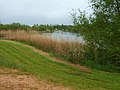 Fisherwick Lakes - geograph.org.uk - 428962.jpg 640 × 480; 97 KB
-
 Fisherwick Trout Pool - geograph.org.uk - 392452.jpg 640 × 480; 54 KB
-

-
 Footpath across the farmland - geograph.org.uk - 4701334.jpg 800 × 591; 158 KB
-
 Footpath On Whittington Heath - geograph.org.uk - 456823.jpg 640 × 480; 112 KB
-
 Freight train near the Coventry Canal - geograph.org.uk - 4706048.jpg 800 × 568; 109 KB
-

-
 Hide and seek - geograph.org.uk - 428977.jpg 640 × 480; 116 KB
-
 Hill Farm, Whittington - geograph.org.uk - 443463.jpg 640 × 480; 97 KB
-
 House along Fisherwick Road - geograph.org.uk - 4707258.jpg 800 × 634; 173 KB
-
 House on the corner of Back Lane - geograph.org.uk - 4701481.jpg 800 × 557; 121 KB
-
 Houses and Green, Hurst Farm - geograph.org.uk - 2507031.jpg 640 × 428; 61 KB
-
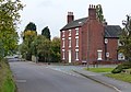
 Housing in Burton Road, Whittington, Staffordshire - geograph.org.uk - 5702559.jpg 1,280 × 960; 1.49 MB
-
 HS2 crosses here - geograph.org.uk - 4701509.jpg 800 × 552; 117 KB
-
 Huddlesford Foot Bridge - geograph.org.uk - 4706006.jpg 800 × 624; 125 KB
-
 Huddlesford Grange - geograph.org.uk - 4370721.jpg 640 × 254; 38 KB
-
 Huddlesford Grange Farm - geograph.org.uk - 4756877.jpg 640 × 426; 54 KB
-
 Huddlesford Grange Farm - geograph.org.uk - 4844563.jpg 640 × 426; 62 KB
-
 Huddlesford Grange Farm - geograph.org.uk - 5700216.jpg 640 × 351; 52 KB
-
 Huddlesford Grange in Staffordshire - geograph.org.uk - 6252512.jpg 1,024 × 683; 857 KB
-
 Huddlesford Junction - geograph.org.uk - 5798175.jpg 640 × 427; 72 KB
-
 Huddlesford Junction - geograph.org.uk - 5798178.jpg 640 × 427; 102 KB
-
 Huddlesford Junction in Staffordshire - geograph.org.uk - 5700904.jpg 1,280 × 842; 1.11 MB
-
 Huddlesford Railway Bridge No 82b - geograph.org.uk - 4705981.jpg 800 × 571; 144 KB
-
 Industry near Whittington Bridge - geograph.org.uk - 4369665.jpg 640 × 341; 28 KB
-
 Lay-by on A38 south near Lichfield - geograph.org.uk - 1870415.jpg 640 × 458; 62 KB
-
 Level Crossing, Hademore - geograph.org.uk - 266192.jpg 640 × 480; 87 KB
-
 Line of pylons at Darnford - geograph.org.uk - 5654109.jpg 6,000 × 4,000; 5.49 MB
-
 Marsh Farm along Darnford Lane - geograph.org.uk - 4701547.jpg 800 × 552; 91 KB
-
 Marsh Lane near Whittington - geograph.org.uk - 4701533.jpg 673 × 800; 161 KB
-
 Modwen Whittington.jpg 1,080 × 1,920; 900 KB
-
 Moored narrowboats at Huddlesford in Staffordshire - geograph.org.uk - 5700240.jpg 1,280 × 849; 1.59 MB
-

-

-
 Narrowboats - geograph.org.uk - 433040.jpg 640 × 480; 102 KB
-

-

-
 Near Huddlesford - geograph.org.uk - 4369670.jpg 640 × 352; 33 KB
-
 Near Whittington - geograph.org.uk - 4369669.jpg 640 × 368; 42 KB
-
 Near Whittington - geograph.org.uk - 456830.jpg 640 × 480; 130 KB
-
 Noddington Bridge No 78 - geograph.org.uk - 4706105.jpg 800 × 600; 171 KB
-

-
 Old canal cruiser in Whittington, Staffordshire - geograph.org.uk - 6249771.jpg 1,280 × 960; 1.63 MB
-
 Packington Hall - geograph.org.uk - 9832.jpg 640 × 480; 115 KB
-
 Passes Bridge near Whittington in Staffordshire - geograph.org.uk - 6249866.jpg 1,600 × 900; 1.94 MB
-

-

-

-

-

-
 Pasture south-east of Huddlesford in Staffordshire - geograph.org.uk - 6252713.jpg 1,600 × 900; 1.53 MB
-
 Pasture south-west of Huddlesford in Staffordshire - geograph.org.uk - 6252491.jpg 1,440 × 960; 1.31 MB
-
 Pasture south-west of Huddlesford in Staffordshire - geograph.org.uk - 6253966.jpg 960 × 1,280; 1.63 MB
-
 Pasture south-west of Huddlesford in Staffordshire - geograph.org.uk - 6254125.jpg 1,440 × 960; 1.45 MB
-
 Pasture south-west of Huddlesford in Staffordshire - geograph.org.uk - 6254130.jpg 960 × 1,280; 1.51 MB
-

-
 Plough Bridge at Huddlesford in Staffordshire - geograph.org.uk - 5700241.jpg 1,280 × 908; 1.38 MB
-
 Plough Bridge at Huddlesford in Staffordshire - geograph.org.uk - 5700244.jpg 1,280 × 817; 1.22 MB
-
 Plough Bridge at Huddlesford in Staffordshire - geograph.org.uk - 6251422.jpg 1,280 × 960; 1.33 MB
-
 Plough Bridge No 83 - geograph.org.uk - 4705964.jpg 800 × 660; 144 KB
-
 Potato field near Whittington in Staffordshire - geograph.org.uk - 6252955.jpg 1,920 × 960; 1.9 MB
-
 Potato field near Whittington in Staffordshire - geograph.org.uk - 6252962.jpg 1,440 × 960; 1.57 MB
-
 Potato field near Whittington in Staffordshire - geograph.org.uk - 6252963.jpg 1,440 × 960; 1.69 MB
-
 Potato field south of Huddlesford in Staffordshire - geograph.org.uk - 6253292.jpg 1,920 × 960; 1.56 MB
-
 Potato field south of Huddlesford in Staffordshire - geograph.org.uk - 6253305.jpg 1,440 × 960; 1.27 MB
-
 Potato field south of Huddlesford in Staffordshire - geograph.org.uk - 6253313.jpg 1,600 × 900; 1.44 MB
-

-
 Private moorings near Huddlesford in Staffordshire - geograph.org.uk - 6254205.jpg 960 × 1,440; 1.68 MB
-
 Public Footpath and Gate - geograph.org.uk - 2507107.jpg 640 × 428; 108 KB
-

-
-

-
 Railway bridge in Huddlesford, Staffordshire - geograph.org.uk - 6252509.jpg 1,440 × 960; 1.7 MB
-
 Railway bridge north of Whittington in Staffordshire - geograph.org.uk - 5701996.jpg 1,280 × 885; 1.11 MB
-
 Railway Bridge over Coventry Canal - geograph.org.uk - 563343.jpg 640 × 480; 91 KB
-
 Railway line near Whittington in Staffordshire - geograph.org.uk - 5702549.jpg 1,280 × 841; 1.03 MB
-
 Railway line near Whittington in Staffordshire - geograph.org.uk - 5702554.jpg 1,280 × 856; 1.16 MB
-

-
 Rape field and pylon near Huddlesford in Staffordshire - geograph.org.uk - 6164143.jpg 1,440 × 1,080; 1.29 MB
-

-
 Remnants of a hedge - geograph.org.uk - 4894849.jpg 640 × 426; 50 KB
-
 Rifle Ranges, Whittington Heath - geograph.org.uk - 2488381.jpg 640 × 428; 51 KB
-
 Roadside and field - geograph.org.uk - 428997.jpg 640 × 480; 106 KB
-
 Royal Antediluvian Order of Buffaloes Whittington.jpg 800 × 582; 156 KB
-
 Sennex House, Brookhay Lane - geograph.org.uk - 2507045.jpg 640 × 428; 80 KB
-
 Sheepwash Farm near Whittington - geograph.org.uk - 4707221.jpg 800 × 557; 138 KB
-
 Single track road - geograph.org.uk - 428989.jpg 640 × 480; 106 KB


