Category:Wigg Island
Jump to navigation
Jump to search
| Object location | | View all coordinates using: OpenStreetMap |
|---|

 | |||||
| Upload media | |||||
| Instance of |
| ||||
|---|---|---|---|---|---|
| Location | Runcorn, Halton, Cheshire, North West England, England | ||||
| Operator |
| ||||
 | |||||
Media in category "Wigg Island"
The following 24 files are in this category, out of 24 total.
-
 'Saxon Stone' Wigg Island Runcorn - panoramio.jpg 3,072 × 2,048; 1.72 MB
-
 A remnant of the Runcorn and Latchford canal on Wigg Island.jpg 4,315 × 2,937; 7.31 MB
-
 Astmoor Saltmarsh - geograph.org.uk - 496486.jpg 640 × 427; 73 KB
-
 Astmoor Saltmarsh and Hempstone Point - geograph.org.uk - 279708.jpg 640 × 457; 158 KB
-
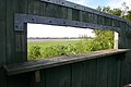
 Bird Hide at Wigg Island - geograph.org.uk - 280003.jpg 640 × 480; 121 KB
-
-
 Former Runcorn-Latchford Canal - geograph.org.uk - 496527.jpg 640 × 427; 66 KB
-

-
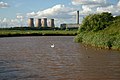
 Manchester Ship Canal at Halton - geograph.org.uk - 496509.jpg 640 × 427; 54 KB
-
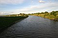
 Manchester Ship Canal at Runcorn - geograph.org.uk - 496503.jpg 640 × 427; 75 KB
-
 Mersey estuary at Wigg Island - geograph.org.uk - 998820.jpg 640 × 419; 80 KB
-
 Mersey sandbanks - geograph.org.uk - 1003166.jpg 640 × 411; 39 KB
-
 Mersey shore at Wigg Island - geograph.org.uk - 1003186.jpg 640 × 415; 89 KB
-
 Old Quay Swing Bridge - geograph.org.uk - 1003182.jpg 640 × 417; 65 KB
-
 River Mersey at Wigg Island - geograph.org.uk - 998816.jpg 640 × 426; 91 KB
-
 Road to Wigg Island - geograph.org.uk - 1003143.jpg 640 × 426; 83 KB
-
 Sand bank on the Mersey - geograph.org.uk - 279722.jpg 640 × 457; 127 KB
-
 The Manchester Ship Canal looking towards Wigg Island from Astmoor in Runcorn.jpg 4,032 × 2,268; 1.95 MB
-
 View from Wigg Island - geograph.org.uk - 1003177.jpg 640 × 413; 57 KB
-
 Wigg Island - geograph.org.uk - 140871.jpg 640 × 426; 82 KB
-
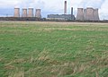
 Wigg Island Runcorn - Fiddlers Ferry - geograph.org.uk - 28206.jpg 640 × 480; 49 KB
-
 Wigg Island Visitor Centre - geograph.org.uk - 836786.jpg 640 × 480; 47 KB
-
 Wigg Island-Runcorn Bridge - geograph.org.uk - 28211.jpg 640 × 480; 61 KB
-


