Category:Wisconsin River
Jump to navigation
Jump to search
English: The Wisconsin River is a tributary of the Mississippi River in the U.S. state of Wisconsin
river in Wisconsin, United States  most silnic 13 a 54 přes řeku u Wisconsin Rapids | |||||
| Upload media | |||||
| Instance of | |||||
|---|---|---|---|---|---|
| Location | Wisconsin | ||||
| Published in |
| ||||
| Length |
| ||||
| Mouth of the watercourse | |||||
| Drainage basin |
| ||||
| Tributary |
| ||||
| Lake on watercourse |
| ||||
 | |||||
Subcategories
This category has the following 26 subcategories, out of 26 total.
B
- Biron, Wisconsin (3 F)
D
G
- Gotham, Wisconsin (5 F)
K
- Knowlton, Wisconsin (7 F)
L
- Lake DuBay (4 F)
- Lone Rock, Wisconsin (25 F)
M
N
P
- Port Andrew, Wisconsin (3 F)
- Portage Canal (11 F)
- Prairie du Sac Dam (12 F)
S
W
Media in category "Wisconsin River"
The following 84 files are in this category, out of 84 total.
-
 Wisconsinrivermap.png 500 × 500; 103 KB
-

-
 An Ordovician clam called Tellinomya.jpg 4,032 × 3,024; 2.27 MB
-

-
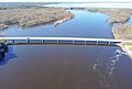
 Bridgeport bridge in Wisconsin-3.jpg 6,923 × 2,512; 12.57 MB
-
 Bridgeport bridge in Wisconsin.jpg 4,000 × 3,000; 7.44 MB
-
 Bridgeport, Wisconsin.jpg 3,951 × 3,948; 11.38 MB
-
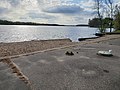 Bukolt Park Beach.jpg 4,032 × 3,024; 6.08 MB
-

-

-
 Colsac III Ferry - panoramio.jpg 4,608 × 3,456; 9.49 MB
-
 Valley of the Wisconsin by John Steuart Curry, 1945, lithograph.jpg 1,920 × 1,462; 501 KB
-

-

-
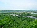
 Driftless Area - panoramio (16).jpg 4,000 × 3,000; 2.2 MB
-
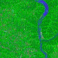
 Driftless Area and the Wisconsin River - panoramio.jpg 5,138 × 3,621; 5.72 MB
-

-
 EffigyMounds L7 25sep01.jpg 4,000 × 4,000; 4.19 MB
-

-
 Fishermen on the Wisconsin River - panoramio.jpg 4,608 × 3,456; 3.05 MB
-
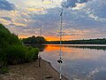 Fishing on the Wisconsin River at Dusk.jpg 4,032 × 3,024; 2.83 MB
-
 FISHING ON THE WISCONSIN RIVER AT MERRILL - NARA - 550810.jpg 3,000 × 2,005; 655 KB
-

-

-
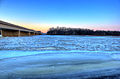 Gfp-frozen-wisconsin-river.jpg 3,392 × 2,229; 935 KB
-
 Gfp-icy-wisconsin-river.jpg 3,370 × 2,205; 738 KB
-

-
 Lake Delton Wisconsin map.png 422 × 372; 8 KB
-
 MerrimacFerryDocksWinter.jpg 2,304 × 1,728; 844 KB
-
 Mosquito Island - panoramio.jpg 5,184 × 3,888; 6.66 MB
-

-

-

-

-

-
 PEPSI CAN FLOATS ON THE WISCONSIN RIVER AT MERRILL - NARA - 550811.jpg 2,031 × 3,000; 698 KB
-

-
 The Pleistocene history of the lower Wisconsin river .. (IA pleistocenehisto00maccrich).pdf 833 × 1,481, 28 pages; 4.25 MB
-
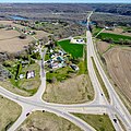
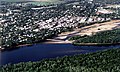 Portage Wisconsin aerial view.jpg 1,500 × 900; 644 KB
-

-

-

-
 SCUM FORMS ON THE WISCONSIN RIVER NEAR THE MOSINEE PAPER COMPANY - NARA - 550814.jpg 3,000 × 2,026; 945 KB
-
 SCUM FORMS ON THE WISCONSIN RIVER NEAR THE MOSINEE PAPER COMPANY - NARA - 550815.jpg 3,000 × 2,015; 1.16 MB
-
 SCUM FORMS ON THE WISCONSIN RIVER NEAR THE MOSINEE PAPER COMPANY - NARA - 550816.jpg 3,000 × 2,018; 1.09 MB
-
 SCUM FORMS ON THE WISCONSIN RIVER NEAR THE MOSINEE PAPER COMPANY - NARA - 550817.jpg 2,024 × 3,000; 1,024 KB
-
 SCUM FORMS ON THE WISCONSIN RIVER NEAR THE MOSINEE PAPER COMPANY - NARA - 550818.jpg 2,033 × 3,000; 819 KB
-

-
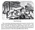 The Portage.jpg 502 × 432; 84 KB
-

-

-

-
 Tower Hill State Park 1.JPG 1,024 × 768; 133 KB
-

-

-
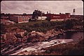
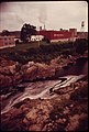
 TOWN OF ENTERPRIZE DUMP, IN ONEIDA COUNTY-ON BANKS OF WISCONSIN RIVER - NARA - 550800.jpg 3,000 × 2,018; 1,022 KB
-
 TOWN OF ENTERPRIZE DUMP, IN ONEIDA COUNTY-ON BANKS OF WISCONSIN RIVER - NARA - 550801.jpg 2,044 × 3,000; 1.09 MB
-
 WATER LILIES ON THE WISCONSIN RIVER AT MERRILL - NARA - 550808.jpg 2,058 × 3,000; 723 KB
-
 WATER LILIES ON THE WISCONSIN RIVER AT MERRILL - NARA - 550809.jpg 3,000 × 2,032; 847 KB
-
 Willow River State Park.jpg 1,920 × 1,280; 791 KB
-
 Wis-21 bridge over Wisconsin River 01.jpg 3,963 × 2,675; 5.98 MB
-
 Wis-21 bridge over Wisconsin River 02.jpg 4,000 × 2,144; 5.8 MB
-
 Wis-21 bridge over Wisconsin River 03.jpg 4,000 × 3,000; 7.12 MB
-
 Wisconsin River - panoramio (1).jpg 4,582 × 2,581; 4.01 MB
-
 Wisconsin River - panoramio (2).jpg 4,000 × 3,000; 2.2 MB
-
 Wisconsin River - panoramio (3).jpg 5,184 × 3,888; 6.95 MB
-
 Wisconsin River - panoramio.jpg 4,896 × 3,672; 5.74 MB
-
 Wisconsin River 5.jpg 4,000 × 2,907; 7.46 MB
-
 Wisconsin River and Round Top Hill - panoramio.jpg 4,000 × 3,000; 3.65 MB
-
 Wisconsin River at Prairie Du Sac - panoramio.jpg 4,608 × 3,456; 2.91 MB
-
 Wisconsin River from Ferry Bluff Hill.JPG 3,264 × 2,448; 1.89 MB
-
 Wisconsin River Marsh - panoramio.jpg 4,608 × 3,456; 7.51 MB
-
 Wisconsin River Marsh near Boscobel - panoramio.jpg 5,184 × 3,888; 6.11 MB
-
 Wisconsin River Seen from State Trunk Highway 23 - panoramio.jpg 4,691 × 3,244; 2.81 MB
-
 Wisconsin River Seen from US Highway 14 - panoramio.jpg 4,686 × 2,708; 2.19 MB
-
 Wisconsin River Tomahawk Wisconsin.jpg 1,936 × 1,288; 818 KB
-
 Wisconsin River.jpg 2,592 × 3,872; 4.06 MB
-
 Wisconsin River.png 514 × 505; 8 KB
-
 Wisconsin's Council Grounds State Park (2008).jpg 1,944 × 2,592; 868 KB
-
 WisconsinRiverBoating.jpg 2,304 × 1,728; 894 KB
-
 WisconsinRiverBuckhornStatePark.jpg 2,218 × 1,605; 385 KB
-
 WisconsinRiverDamStevensPoint.jpg 1,024 × 768; 452 KB
-
 Wiscosnin River at Portage - panoramio.jpg 4,896 × 3,672; 5.97 MB
-
 WyalusingStateParkWisconsinRiverIntoMississippiRiver.jpg 2,288 × 1,712; 744 KB


_(14777004455).jpg)

.jpg)


.jpg)
.jpg)
.jpg)


.jpg)


