Category:Woodhead, Derbyshire
Jump to navigation
Jump to search
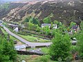
English: Woodhead is a small and scattered settlement at the head of the Longdendale valley in Derbyshire, England. It lies on the River Etherow and the Trans Pennine Trail. Like nearby Tintwistle, it was formerly in the county of Cheshire before local government re-organisation in 1974.
hamlet in Tintwistle, Derbyshire, United Kingdom  | |||||
| Upload media | |||||
| Instance of | |||||
|---|---|---|---|---|---|
| Location | Tintwistle, High Peak, Derbyshire, East Midlands, England | ||||
 | |||||
Subcategories
This category has the following 7 subcategories, out of 7 total.
F
- Far Black Clough, Bleaklow (24 F)
J
- St James' Chapel, Woodhead (12 F)
M
N
- Near Black Clough, Bleaklow (19 F)
R
- Woodhead Reservoir (74 F)
T
- Woodhead Tunnel (45 F)
W
- Woodhead railway station (32 F)
Media in category "Woodhead, Derbyshire"
The following 51 files are in this category, out of 51 total.
-
 "Oaksike Clough" bottom - geograph.org.uk - 383057.jpg 640 × 480; 103 KB
-
 A628 Path to Woodhead Tunnels - geograph.org.uk - 1655568.jpg 640 × 480; 66 KB
-
 Audernshaw Clough - geograph.org.uk - 518430.jpg 640 × 480; 90 KB
-

-

-
 Bleak House on the A628 - geograph.org.uk - 486156.jpg 640 × 477; 130 KB
-
 Crowden Station.JPG 3,264 × 2,448; 1.49 MB
-
 Derelict Hut Withens Moor - geograph.org.uk - 388250.jpg 640 × 480; 179 KB
-
 Derelict Sheep Fold - geograph.org.uk - 387222.jpg 640 × 480; 173 KB
-
 Entrance stile to Withens Moor. - geograph.org.uk - 387147.jpg 640 × 480; 138 KB
-
 Etherow valley from above Woodhead Tunnel entrance - geograph.org.uk - 2843017.jpg 5,184 × 3,456; 4.95 MB
-
 Hey Clough - geograph.org.uk - 386351.jpg 640 × 480; 110 KB
-
 Hey Clough Top - geograph.org.uk - 383502.jpg 640 × 480; 116 KB
-
 Hey Edge looking to Westend Moss - geograph.org.uk - 383230.jpg 640 × 480; 79 KB
-
 Longdendale from Woodhead.jpg 2,048 × 1,536; 652 KB
-

-
 Old field boundary wall with derelict hut - geograph.org.uk - 387096.jpg 640 × 480; 159 KB
-
 Old House Tunnel - geograph.org.uk - 5007251.jpg 3,648 × 2,736; 4.81 MB
-

-
 Pikenaze Farm and Farmland by A628 - geograph.org.uk - 264413.jpg 640 × 230; 21 KB
-
 Private road ahead - geograph.org.uk - 462811.jpg 640 × 466; 96 KB
-
 Pylon Woodhead.jpg 600 × 800; 153 KB
-
 Quarry - geograph.org.uk - 382766.jpg 640 × 480; 96 KB
-
 Right hand bend ahead - geograph.org.uk - 462798.jpg 640 × 480; 125 KB
-
 River Etherow - geograph.org.uk - 457284.jpg 640 × 480; 101 KB
-
 Road gritter to the rescue - geograph.org.uk - 675547.jpg 640 × 480; 60 KB
-
 Salters Brook Bridge - geograph.org.uk - 34385.jpg 640 × 480; 58 KB
-
 St James Chapel track to the A628 - geograph.org.uk - 486164.jpg 640 × 480; 93 KB
-
 Stile to open country - geograph.org.uk - 836403.jpg 640 × 480; 98 KB
-

-
 The River Etherow - geograph.org.uk - 426562.jpg 640 × 467; 121 KB
-
 The River Etherow - geograph.org.uk - 457287.jpg 640 × 480; 100 KB
-
 The River Etherow - geograph.org.uk - 457857.jpg 640 × 480; 110 KB
-
 Top of Ancote Hill - geograph.org.uk - 383508.jpg 640 × 480; 116 KB
-
 Track to old quarry - geograph.org.uk - 462788.jpg 640 × 480; 115 KB
-

-
 Valve Station To The West Of Bleak House, Woodhead Road, Derbyshire 1.jpg 1,800 × 1,200; 2.46 MB
-
 Valve Station To The West Of Bleak House, Woodhead Road, Derbyshire 3.jpg 1,800 × 1,200; 1.89 MB
-
 Valve Station To The West Of Bleak House, Woodhead Road, Derbyshire 4.jpg 1,800 × 1,200; 2.21 MB
-
 Valve Station To The West Of Bleak House, Woodhead Road, Derbyshire 5.jpg 1,800 × 1,200; 1.83 MB
-
 Valve Station To The West Of Bleak House, Woodhead Road, Derbyshire 6.jpg 1,800 × 1,200; 1.79 MB
-
 Where two trails meet - geograph.org.uk - 3291490.jpg 800 × 533; 77 KB
-
 White Stones - geograph.org.uk - 328924.jpg 640 × 426; 93 KB
-
 Woodhead - geograph.org.uk - 2722756.jpg 800 × 533; 198 KB
-
 Woodhead - geograph.org.uk - 3790923.jpg 3,888 × 2,592; 1.1 MB
-
 Woodhead - geograph.org.uk - 3791312.jpg 2,447 × 3,789; 1.28 MB
-
 Woodhead - geograph.org.uk - 431543.jpg 640 × 480; 132 KB
-
 Woodhead ballast geograph-2190858.jpg 1,024 × 590; 258 KB
-
 Woodhead Bridge - geograph.org.uk - 3791111.jpg 3,690 × 1,809; 852 KB
-
 Woodhead Bridge - geograph.org.uk - 3791324.jpg 3,817 × 2,007; 1.16 MB
-
 WoodheadDerbyshire.jpg 800 × 533; 195 KB


