Category:Wootton Rivers
Jump to navigation
Jump to search
village in the United Kingdom  | |||||
| Upload media | |||||
| Instance of | |||||
|---|---|---|---|---|---|
| Location | Wiltshire, South West England, England | ||||
 | |||||
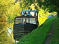
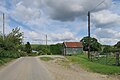
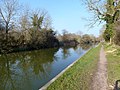
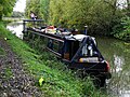
English: Wootton Rivers is a small village located between Pewsey and Marlborough in Wiltshire. It is home to the Wootton Rivers Lock, and the Royal Oak pub.
Nederlands: Wootton Rivers is een dorp (village) en civil parish in de unitary authority Wiltshire, in het Engelse graafschap Wiltshire. De civil parish telt
Subcategories
This category has the following 3 subcategories, out of 3 total.
Media in category "Wootton Rivers"
The following 200 files are in this category, out of 295 total.
(previous page) (next page)-

-

-

-

-

-

-

-
-

-
-

-
 18 Wootton Rivers.jpg 6,000 × 4,000; 9.17 MB
-
 2011 , North west near Ram Alley - geograph.org.uk - 2724679.jpg 3,996 × 2,307; 1.89 MB
-
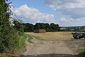
 2011 , Track through a field of winter wheat - geograph.org.uk - 2724763.jpg 3,631 × 2,177; 2.54 MB
-
 2011 , West near the minor road through Ram Alley - geograph.org.uk - 2724706.jpg 4,133 × 2,001; 2.03 MB
-
 2012 , Approaching Wootton Rivers from the north east - geograph.org.uk - 2838566.jpg 3,918 × 2,692; 3.87 MB
-
 2012 , Byway to Heathy Close - geograph.org.uk - 2846094.jpg 3,898 × 2,862; 6.63 MB
-

-
 2012 , East over farmland near Wootton Rivers - geograph.org.uk - 2846040.jpg 4,302 × 2,503; 4.37 MB
-
 2012 , Entering Wootton Rivers on Forest Road - geograph.org.uk - 2846089.jpg 3,246 × 2,587; 2.39 MB
-
 2012 , Field of oilseed rape near Wotton Rivers - geograph.org.uk - 2848964.jpg 4,264 × 1,981; 2.84 MB
-
 2012 , Footpath and bridleway off Forest Road - geograph.org.uk - 2846072.jpg 3,000 × 2,000; 3.86 MB
-
 2012 , Forest Road heading out of Wootton Rivers - geograph.org.uk - 2838595.jpg 4,472 × 3,155; 5.76 MB
-
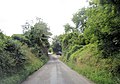
 2012 , Minor road out of Wootton Rivers - geograph.org.uk - 2848953.jpg 4,003 × 2,230; 3.61 MB
-
 2012 , Ploughed field west of Forest Road - geograph.org.uk - 2846061.jpg 4,413 × 2,555; 4.51 MB
-
 2012 , Ploughed fields north west of Forest Road - geograph.org.uk - 2846082.jpg 4,608 × 2,229; 4.54 MB
-
 2012 , Thatched cottage on Forest Road - geograph.org.uk - 2846105.jpg 3,449 × 2,601; 3.4 MB
-
 2012 , West near Wootton Rivers - geograph.org.uk - 2838541.jpg 4,184 × 2,340; 4.06 MB
-
 A barn and fields - geograph.org.uk - 4552881.jpg 640 × 480; 130 KB
-

-

-
-

-

-

-
 Apshill Copse, near Wootton Rivers - geograph.org.uk - 1327622.jpg 640 × 480; 202 KB
-
 Ashill Copse - geograph.org.uk - 4644321.jpg 640 × 426; 33 KB
-
 Bare fields above Wootton Rivers - geograph.org.uk - 4675212.jpg 640 × 427; 98 KB
-
-
 Beneath Martinsell Hill - geograph.org.uk - 282604.jpg 640 × 480; 136 KB
-
 Bracket fungus (1), Kennet and Avon Canal - geograph.org.uk - 6310308.jpg 1,024 × 768; 473 KB
-
 Bracket fungus (2), Kennet and Avon Canal - geograph.org.uk - 6310312.jpg 1,024 × 768; 227 KB
-
 Bracket fungus (3), Kennet and Avon Canal - geograph.org.uk - 6310317.jpg 1,024 × 768; 324 KB
-

-

-

-
 Bridge 110, Kennet and Avon Canal - geograph.org.uk - 1469491.jpg 640 × 480; 195 KB
-
 Bridge 110, Kennet and Avon Canal - geograph.org.uk - 1469507.jpg 640 × 480; 188 KB
-

-

-
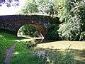
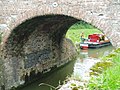
 Brimslade bridge (no 106) and lock (no 53) - geograph.org.uk - 3704308.jpg 1,024 × 615; 162 KB
-
 Brimslade Bridge (No 106) from the north - geograph.org.uk - 4494887.jpg 1,024 × 768; 139 KB
-

-
-
 Building at Church Farm - geograph.org.uk - 5525640.jpg 4,000 × 3,000; 3.9 MB
-
 Buildings at Brimslade Farm - geograph.org.uk - 4494913.jpg 1,024 × 768; 127 KB
-
 Cadley bridge (no 105) - geograph.org.uk - 3700643.jpg 1,024 × 768; 203 KB
-
 Cadley Lock - geograph.org.uk - 4733934.jpg 1,200 × 806; 1.36 MB
-

-
 Cadley Lock No 54 and Cadley Bridge - geograph.org.uk - 415371.jpg 640 × 504; 121 KB
-
 Cadley Lock No 54, Kennet and Avon Canal - geograph.org.uk - 856305.jpg 640 × 480; 124 KB
-
 Canal across a field - geograph.org.uk - 5564086.jpg 640 × 426; 57 KB
-

-
-
 Canal Wootton river - panoramio.jpg 4,000 × 3,000; 4.85 MB
-
 Car on a lane near East Wick farm - geograph.org.uk - 2067000.jpg 640 × 480; 133 KB
-
-
-
 Clock House Wootton Rivers.jpg 6,000 × 4,000; 10.19 MB
-
 Cock Lane - geograph.org.uk - 121155.jpg 640 × 481; 83 KB
-

-
 Cuckoo's Knob (1) - geograph.org.uk - 1327587.jpg 640 × 480; 166 KB
-
 Cuckoo's Knob (2) - geograph.org.uk - 1327610.jpg 640 × 480; 170 KB
-
 Cuckoo's Knob (3) - geograph.org.uk - 1327614.jpg 640 × 480; 183 KB
-
 Cuckoo's Knob - geograph.org.uk - 4587511.jpg 640 × 480; 100 KB
-
 Cuckoo's Knob - geograph.org.uk - 5830435.jpg 1,024 × 681; 108 KB
-
 Dismantled railway bridge - geograph.org.uk - 4393596.jpg 640 × 480; 182 KB
-
 Downland view above East Wick Farm - geograph.org.uk - 4675246.jpg 640 × 427; 103 KB
-

-
 East along the Kennet and Avon Canal near Wootton Rivers - geograph.org.uk - 2510180.jpg 1,440 × 1,080; 883 KB
-

-
 East Wick Farm - geograph.org.uk - 4587478.jpg 640 × 480; 58 KB
-
 East Wick Farm - geograph.org.uk - 4675234.jpg 640 × 427; 100 KB
-
 Eastbound Hitachi train, Wootton Rivers - geograph.org.uk - 6310327.jpg 1,024 × 768; 164 KB
-
 Entrance to Wootton Rivers - geograph.org.uk - 4587491.jpg 640 × 480; 113 KB
-
 Farm buildings - geograph.org.uk - 4587486.jpg 640 × 480; 52 KB
-
 Farmland between the canal and the railway - geograph.org.uk - 3700844.jpg 1,024 × 768; 116 KB
-
 Farmland near Cuckoo's Knob - geograph.org.uk - 5125471.jpg 640 × 426; 48 KB
-
 Farmland north of Wootton Rivers - geograph.org.uk - 1327629.jpg 640 × 480; 154 KB
-
 Farmland south of Little Clench - geograph.org.uk - 4494845.jpg 1,024 × 768; 132 KB
-
 Farmland, Wootton Rivers - geograph.org.uk - 2318369.jpg 640 × 480; 189 KB
-
 Farmland, Wootton Rivers - geograph.org.uk - 2318382.jpg 640 × 480; 135 KB
-
 Farmland, Wootton Rivers - geograph.org.uk - 2318385.jpg 640 × 427; 81 KB
-
 Farmland, Wootton Rivers - geograph.org.uk - 282552.jpg 640 × 480; 92 KB
-
 Farmland, Wootton Rivers - geograph.org.uk - 4373271.jpg 640 × 480; 215 KB
-
 Farmland, Wootton Rivers - geograph.org.uk - 4373298.jpg 640 × 480; 153 KB
-
 Field and rough grassland - geograph.org.uk - 5125475.jpg 640 × 426; 49 KB
-
-
 Field by East Wick Farm - geograph.org.uk - 5526539.jpg 3,887 × 2,592; 3.12 MB
-
 Footpath to Cuckoo's Knob - geograph.org.uk - 121159.jpg 640 × 481; 47 KB
-
 Forest Road north of Brimslade Farm - geograph.org.uk - 3621806.jpg 3,209 × 2,427; 1.57 MB
-
 Forest Road northwest of Brimslade Farm - geograph.org.uk - 3621830.jpg 3,560 × 2,499; 1.69 MB
-
 Forest Road transects disused railway track - geograph.org.uk - 3621783.jpg 3,632 × 2,539; 2.07 MB
-
 Forest Road Wootton Rivers - geograph.org.uk - 2195433.jpg 640 × 480; 336 KB
-

-

-
 Grassland and woodland - geograph.org.uk - 5383451.jpg 640 × 426; 39 KB
-

-
 Heathy Close farmland - geograph.org.uk - 3700855.jpg 1,024 × 768; 170 KB
-
 Heathy Close Lock - geograph.org.uk - 4675218.jpg 640 × 427; 105 KB
-
 Hedgeline - geograph.org.uk - 5830437.jpg 1,024 × 630; 112 KB
-
 Hedgeline - geograph.org.uk - 5868043.jpg 1,024 × 529; 78 KB
-
 Horses on north bank, Kennet ^ Avon canal - geograph.org.uk - 3700654.jpg 1,024 × 768; 134 KB
-
 House martin and its nest, Wootton Rivers - geograph.org.uk - 502337.jpg 640 × 479; 289 KB
-

-
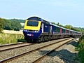
 HST 125 (High Speed Train) en route for the south-west - geograph.org.uk - 2509856.jpg 1,440 × 1,080; 770 KB
-
 Hut at East Wick Farm - geograph.org.uk - 5526540.jpg 3,645 × 2,430; 2.15 MB
-
 K&A-B106.JPG 2,272 × 1,704; 1.51 MB
-
 Kennet , bushes ^ fields - geograph.org.uk - 2588546.jpg 2,560 × 1,920; 2.28 MB
-
 Kennet , Grassy Field - geograph.org.uk - 2588508.jpg 2,476 × 1,802; 1.47 MB
-
 Kennet , Ploughed Field - geograph.org.uk - 2588520.jpg 2,560 × 1,920; 1.82 MB
-
 Kennet and Avon Canal - geograph.org.uk - 4393492.jpg 640 × 480; 151 KB
-
 Kennet and Avon Canal - geograph.org.uk - 4631870.jpg 640 × 439; 62 KB
-
 Kennet and Avon Canal - geograph.org.uk - 4644437.jpg 640 × 371; 60 KB
-
 Kennet And Avon Canal - geograph.org.uk - 5782626.jpg 640 × 380; 68 KB
-
 Kennet and Avon Canal - geograph.org.uk - 86810.jpg 640 × 480; 118 KB
-
 Kennet and Avon Canal between Wootton Rivers and Pewsey Wharf - geograph.org.uk - 2510757.jpg 1,440 × 1,080; 1,018 KB
-

-

-

-
 Kennet ^ Avon Canal - geograph.org.uk - 5564089.jpg 640 × 361; 80 KB
-
 Kennet ^ Avon Canal - geograph.org.uk - 6058481.jpg 1,024 × 534; 149 KB
-
 Kennet ^ Avon canal between bridges 111 and 110 - geograph.org.uk - 3701946.jpg 1,024 × 768; 173 KB
-
 Kennet ^ Avon canal east of Cadley bridge - geograph.org.uk - 3700638.jpg 1,024 × 768; 175 KB
-
 Kennet ^ Avon canal near Ram Alley copse - geograph.org.uk - 3700630.jpg 1,024 × 768; 129 KB
-
 Kennet ^ Avon Canal Walk - geograph.org.uk - 5648957.jpg 640 × 480; 78 KB
-
 Kennet ^ Avon Canal Walk - geograph.org.uk - 5648965.jpg 640 × 480; 75 KB
-
 Kennet ^ Avon Canal Walk - geograph.org.uk - 5648976.jpg 640 × 480; 83 KB
-
 Lane junction near East Wick Farm - geograph.org.uk - 2066999.jpg 640 × 480; 200 KB
-
 Lock at Kennet ^ Avon Canal, Wootton Rivers - geograph.org.uk - 5525636.jpg 3,026 × 1,777; 2.51 MB
-
 Lock at Kennet ^ Avon Canal, Wootton Rivers - geograph.org.uk - 5525637.jpg 3,062 × 1,666; 2.2 MB
-

-
 Lock Cottage, Brimslade, Marlborough - geograph.org.uk - 5161158.jpg 640 × 480; 116 KB
-
 Lock House, Wootton Rivers - geograph.org.uk - 3700871.jpg 1,024 × 768; 105 KB
-
 Lock moorings below Brimslade Lock (no 53) - geograph.org.uk - 3700676.jpg 1,024 × 768; 144 KB
-
 Low railway embankment, near Heathy Close Bridge - geograph.org.uk - 3700843.jpg 1,024 × 768; 131 KB
-
 Mainline at Wootton Rivers looking northeast - geograph.org.uk - 3623358.jpg 4,000 × 3,000; 4.8 MB
-

-
 Mid Wilts Way, heading north-east - geograph.org.uk - 4494871.jpg 1,024 × 768; 184 KB
-
 Mud Lane - geograph.org.uk - 1323640.jpg 640 × 480; 170 KB
-
 Muntjac deer, north of Wootton Rivers - geograph.org.uk - 1327624.jpg 640 × 480; 212 KB
-
 Mushrooms at the mooring below Cadley lock - geograph.org.uk - 3704311.jpg 1,024 × 768; 194 KB
-

-

-

-
-

-

-
-

-

-

-

-

-

-
 Narrowboats moored between bridges 109 and 108 - geograph.org.uk - 3704286.jpg 1,024 × 768; 176 KB
-
 Narrowboats moored between locks 51 and 52 - geograph.org.uk - 3704306.jpg 1,024 × 768; 180 KB
-

-
 Near Carrel Crown Bridge - geograph.org.uk - 4784869.jpg 3,072 × 1,625; 918 KB
-

-
 Nice house in Wootton river anyone now its name - panoramio.jpg 3,521 × 2,461; 2.58 MB
-

-

-
 Old barn near The Long House - geograph.org.uk - 1327562.jpg 640 × 480; 157 KB
-

-
 Outbuilding at Wootton House - geograph.org.uk - 5525641.jpg 4,000 × 3,000; 3.57 MB
-
 Paddocks east of Brimslade Farm - geograph.org.uk - 3700666.jpg 1,024 × 768; 105 KB
-
 Path along field edge at East Wick Farm - geograph.org.uk - 4675237.jpg 640 × 427; 105 KB
-
 Path beside barn at East Wick Farm - geograph.org.uk - 4675235.jpg 640 × 427; 120 KB
-
 Pillbox by the Kennet ^ Avon Canal - geograph.org.uk - 4885804.jpg 640 × 311; 58 KB
-
 Pillbox in a field - geograph.org.uk - 4644308.jpg 640 × 426; 46 KB
-

-

-
 Pillbox on hillside - geograph.org.uk - 5193431.jpg 640 × 426; 40 KB
-
 Pillbox south-west of Wootton Rivers (1) - geograph.org.uk - 4494853.jpg 1,024 × 768; 167 KB
-
 Pillbox south-west of Wootton Rivers (2) - geograph.org.uk - 4494857.jpg 1,024 × 768; 165 KB
-

-
 Pylon, near Easton Royal, Wiltshire - geograph.org.uk - 357363.jpg 480 × 640; 106 KB
-
 Railway at Brimslade - geograph.org.uk - 4735320.jpg 1,200 × 834; 1.18 MB
-
 Railway at Wootton Rivers - geograph.org.uk - 4733940.jpg 1,200 × 803; 1.37 MB
-

-

-
 Rainbow over the fields at Wootton Rivers - geograph.org.uk - 3875816.jpg 5,536 × 2,160; 4.12 MB
-
-

-
 Reeves Cottage Wootton Rivers.jpg 6,000 × 4,000; 8.95 MB
-
-
 Road junction - geograph.org.uk - 4587506.jpg 640 × 480; 90 KB
-
 Road leading up past Royal Oak pub - geograph.org.uk - 5650289.jpg 640 × 480; 71 KB
-
 Road towards Savernake Forest - geograph.org.uk - 4393555.jpg 640 × 480; 165 KB


_-_geograph.org.uk_-_5160975.jpg)
_-_geograph.org.uk_-_5160980.jpg)


,_Kennet_and_Avon_Canal_-_geograph.org.uk_-_6310308.jpg)
,_Kennet_and_Avon_Canal_-_geograph.org.uk_-_6310312.jpg)
,_Kennet_and_Avon_Canal_-_geograph.org.uk_-_6310317.jpg)


_and_lock_(no_53)_-_geograph.org.uk_-_3704308.jpg)
_from_the_north_-_geograph.org.uk_-_4494887.jpg)


_-_geograph.org.uk_-_3700643.jpg)


,_St_Andrews_Church,_Wootton_Rivers,_Wiltshire_-_geograph.org.uk_-_4159978.jpg)
,_St_Andrews_Church,_Wootton_Rivers,_Wiltshire_-_geograph.org.uk_-_4159979.jpg)


_-_geograph.org.uk_-_1327587.jpg)
_-_geograph.org.uk_-_1327610.jpg)
_-_geograph.org.uk_-_1327614.jpg)


_en_route_for_the_south-west_-_geograph.org.uk_-_2509856.jpg)


_-_geograph.org.uk_-_3700676.jpg)


_-_geograph.org.uk_-_4161245.jpg)
_-_geograph.org.uk_-_4161868.jpg)


_-_geograph.org.uk_-_4494853.jpg)
_-_geograph.org.uk_-_4494857.jpg)


