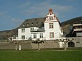
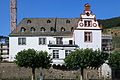
Category:Zehnthof Leutesdorf
Jump to navigation
Jump to search
| Object location | | View all coordinates using: OpenStreetMap |
|---|
 | |||||
| Upload media | |||||
| Instance of | |||||
|---|---|---|---|---|---|
| Location | Leutesdorf, Bad Hönningen, Neuwied, Rhineland-Palatinate, Germany | ||||
 | |||||
Media in category "Zehnthof Leutesdorf"
The following 11 files are in this category, out of 11 total.
-
 Die Zinn.JPG 1,280 × 960; 334 KB
-
 Kurtrierischer Zehnthof.jpg 3,456 × 2,304; 2.88 MB
-
 Leutesdorf (Namedy) 09 ies.jpg 5,616 × 3,744; 21.78 MB
-
 Leutesdorf - Rheinstraße + Zehnthof 01 ies.jpg 5,616 × 3,744; 16.03 MB
-
 Leutesdorf - Rheinstraße + Zehnthof 02 ies.jpg 5,616 × 3,744; 17.32 MB
-
 Leutesdorf - Rheinstraße + Zehnthof 03 ies.jpg 5,616 × 3,744; 16.66 MB
-
 Leutesdorf - Rheinstraße - Zehnthof 01 ies.jpg 5,616 × 3,744; 12.17 MB
-
 Leutesdorf - Rheinstraße - Zehnthof 02 ies.jpg 5,616 × 3,744; 18.91 MB
-
 Leutesdorf - Rheinstraße - Zehnthof 03 ies.jpg 3,744 × 5,616; 15.86 MB
-
 Leutesdorf - Rheinstraße - Zehnthof 04 ies.jpg 5,616 × 3,744; 18.32 MB
-
 Zinn1.jpg 2,499 × 1,875; 2.12 MB

_09_ies.jpg)


