Category:Zottbachbrücke
Jump to navigation
Jump to search
| Object location | | View all coordinates using: OpenStreetMap |
|---|
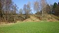
This is the category of the Bavarian Baudenkmal (cultural heritage monument) with the ID D-3-74-147-66 (Wikidata)
|
 | |||||
| Upload media | |||||
| Instance of | |||||
|---|---|---|---|---|---|
| Location | Pleystein, Neustadt an der Waldnaab, Upper Palatinate, Bavaria, Germany | ||||
| Street address |
| ||||
| Crosses | |||||
| Heritage designation | |||||
| Inception |
| ||||
 | |||||
Media in category "Zottbachbrücke"
The following 11 files are in this category, out of 11 total.
-
 LohmaZottbachbruecke 01.jpg 2,304 × 1,704; 874 KB
-
 LohmaZottbachbruecke 02.jpg 2,304 × 1,704; 893 KB
-
 LohmaZottbachbruecke 03.jpg 4,608 × 2,592; 2.16 MB
-
 LohmaZottbachbruecke 04.jpg 4,608 × 2,592; 2.17 MB
-
 LohmaZottbachbruecke 05.jpg 4,608 × 2,592; 2.16 MB
-
 LohmaZottbachbruecke 06.jpg 4,608 × 2,592; 2.23 MB
-
 LohmaZottbachbruecke 07.jpg 4,608 × 2,592; 2.16 MB
-
 LohmaZottbachbruecke 08.jpg 4,608 × 2,592; 2.15 MB
-
 LohmaZottbachbruecke 09.jpg 4,608 × 2,592; 2.16 MB
-
 LohmaZottbachbruecke 10.jpg 4,608 × 2,592; 2.13 MB
-
 LohmaZottbachbruecke 11.jpg 4,608 × 2,592; 2.16 MB


