Category:Kronobergs slott
Jump to navigation
Jump to search
|
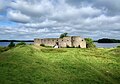
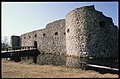
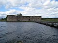
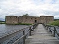
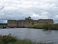
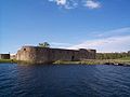
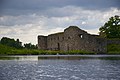
This is a category about an archaeological site or a monument in Sweden, number Växjö 93:1 in the RAÄ Fornsök database. |
is the medieval ruin. Due to its strategic location near the border between Sweden and Denmark, at 1540s the castle was further fortified and became a stronghold in this part of Småland.  | |||||
| Upload media | |||||
| Instance of |
| ||||
|---|---|---|---|---|---|
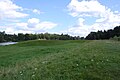
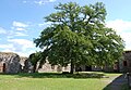
| Location | Växjö Municipality, Kronoberg County, Sweden | ||||
| Located in or next to body of water | |||||
| Owned by | |||||
| Operator |
| ||||
| Heritage designation |
| ||||
| official website | |||||
 | |||||
Subcategories
This category has the following 2 subcategories, out of 2 total.
Pages in category "Kronobergs slott"
This category contains only the following page.
Media in category "Kronobergs slott"
The following 62 files are in this category, out of 62 total.
-
 201107 - Kronobergs slottsruin 03.JPG 482 × 624; 241 KB
-
 201107 - Kronobergs slottsruin 08.JPG 637 × 850; 265 KB
-
 201107 - Kronobergs slottsruin 10.JPG 850 × 555; 264 KB
-
 Blick auf Kronoberg.jpg 2,790 × 1,774; 1.31 MB
-
 Blick über Stallholmen.jpg 3,008 × 2,000; 1.2 MB
-
 Frontal view of ruins from the main land..jpg 5,184 × 3,456; 12.73 MB
-
 Hjørnetårn fra Kronoberg borgruin.jpg 3,893 × 2,920; 9.37 MB
-
 Innenhof Kronoberg.jpg 2,668 × 1,845; 1.24 MB
-
 Kronoberg borgruin.jpg 3,735 × 2,618; 7.86 MB
-
 Kronoberg Castle , Lake Helgasjön october 2008 - panoramio.jpg 3,918 × 2,035; 4.75 MB
-
 Kronoberg castle - panoramio.jpg 2,560 × 1,920; 2.28 MB
-
 Kronoberg LC0227.jpg 3,969 × 1,600; 4.71 MB
-
 Kronobergs Castle 2004-04-12.jpg 2,288 × 915; 330 KB
-
 Kronobergs Slott (2377253783).jpg 3,488 × 2,616; 4.44 MB
-
 Kronobergs slottsruin - KMB - 16001000022306.jpg 570 × 609; 224 KB
-
 Kronobergs slottsruin - KMB - 16001000022308.jpg 570 × 607; 232 KB
-
 Kronobergs slottsruin - KMB - 16001000022310.jpg 570 × 611; 276 KB
-
 Kronobergs slottsruin - KMB - 16001000022312.jpg 570 × 604; 234 KB
-
 Kronobergs slottsruin - KMB - 16001000036884.jpg 788 × 519; 103 KB
-
 Kronobergs slottsruin - KMB - 16001000037106.jpg 782 × 521; 73 KB
-
 Kronobergs slottsruin - KMB - 16001000056904.jpg 781 × 525; 83 KB
-
 Kronobergs slottsruin - KMB - 16001000058386.jpg 786 × 516; 76 KB
-
 Kronobergs slottsruin - KMB - 16001000058404.jpg 786 × 516; 106 KB
-
 Kronobergs slottsruin, 20220807 080737920.jpg 4,080 × 3,072; 5.04 MB
-
 Kronobergs slottsruin, 20220807, bild 2.jpg 4,080 × 3,072; 3.4 MB
-
 Kronobergs slottsruin, 20220807.jpg 4,080 × 3,072; 3.76 MB
-
 Kronobergs slottsruin, borggården, 2015a.jpg 2,048 × 1,536; 1.47 MB
-
 Kronobergs slottsruin, borggården, 2015b.jpg 2,048 × 1,536; 1.52 MB
-
 Kronobergs slottsruin, borggården, 2015c.jpg 2,048 × 1,536; 1.19 MB
-
 Kronobergs slottsruin, borggården, 2015d.jpg 2,048 × 1,536; 1.42 MB
-
 Kronobergs slottsruin, borggården, 2015e.jpg 2,048 × 1,536; 1.03 MB
-
 Kronobergs slottsruin, borggården, 2015f.jpg 2,048 × 1,536; 1.33 MB
-
 Kronobergs slottsruin, borggården, 2015g.jpg 2,048 × 1,536; 1.52 MB
-
 Kronobergs slottsruin, borggården, 2015h.jpg 1,536 × 2,048; 1.45 MB
-
 Kronobergs slottsruin, borgruinen från norr, 2015a.jpg 2,048 × 1,536; 1.19 MB
-
 Kronobergs slottsruin, borgruinen från norr, 2015b.jpg 2,048 × 1,536; 1.4 MB
-
 Kronobergs slottsruin, broarna till borgruinen, 2015.jpg 2,048 × 1,536; 890 KB
-
 Kronobergs slottsruin, bron från Stallholmen till borgruinen, 2015.jpg 2,048 × 1,536; 971 KB
-
 Kronobergs slottsruin, bron från Stallholmen till Vaktholmen, 2015.jpg 2,048 × 1,536; 972 KB
-
 Kronobergs slottsruin, bron från Vaktholmen till Stallholmen, 2015.jpg 2,048 × 1,536; 886 KB
-
 Kronobergs slottsruin, Helgasjön från Stallholmen, 2015.jpg 2,048 × 1,536; 951 KB
-
 Kronobergs slottsruin, Helgasjön och broarna, 2015.jpg 2,048 × 1,536; 1.03 MB
-
 Kronobergs slottsruin, vallgraven från norra borgsidan, 2015a.jpg 2,048 × 1,536; 898 KB
-
 Kronobergs slottsruin, vallgraven från norra borgsidan, 2015b.jpg 2,048 × 1,536; 916 KB
-
 Kronobergs slottsruin, vallgraven från norra borgsidan, 2015c.jpg 2,048 × 1,536; 1.1 MB
-
 Kronobergs slottsruin, vallgraven från södra borgsidan, 2015a.jpg 2,048 × 1,536; 1.07 MB
-
 Kronobergs slottsruin, vallgraven från södra borgsidan, 2015b.jpg 2,048 × 1,536; 918 KB
-
 Kronobergs slottsruin, vy från landfästet mot slottsruinen, 2015.jpg 2,048 × 1,536; 869 KB
-
 Kronobergs slottsruin, västra portvalvet in mot borggården, 2015.jpg 1,536 × 2,048; 1.15 MB
-
 Kronobergs slottsruin-front.jpg 1,151 × 494; 81 KB
-
 Kronobergs slottsruin-left.jpg 1,152 × 864; 121 KB
-
 Kronobergs slottsruin.jpg 1,000 × 667; 203 KB
-
 Kronobergs Slottsruin.JPG 2,048 × 2,048; 1.11 MB
-
 Kronobergs-slottsruin.jpg 5,316 × 3,388; 9.81 MB
-
 LA2-vx06-kronoberg1.jpg 2,272 × 1,704; 1.03 MB
-
 LA2-vx06-kronoberg2.jpg 2,272 × 1,704; 688 KB
-
 LA2-vx06-kronoberg3.jpg 2,272 × 1,704; 777 KB
-
 LA2-vx06-kronoberg4.jpg 2,272 × 1,704; 733 KB
-
 LA2-vx06-kronoberg5.jpg 2,272 × 1,704; 787 KB
-
 S-S Thor utanför Kronobergs slottsruin.jpg 4,992 × 3,328; 10.47 MB
-
 Schlossruine Kronoberg.jpg 4,608 × 3,072; 4.09 MB
-
 Руины замка Крунуберг.jpg 4,288 × 2,848; 4.84 MB


.jpg)


