Category:Evang Pfarrkirche (Nickelsdorf)
Jump to navigation
Jump to search
| Object location | | View all coordinates using: OpenStreetMap |
|---|
church building in Nickelsdorf, Austria .JPG) | |||||
| Upload media | |||||
| Instance of | |||||
|---|---|---|---|---|---|
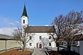
| Location | Nickelsdorf, Neusiedl am See District, Burgenland, Austria | ||||
| Street address |
| ||||
| Heritage designation | |||||
 | |||||
Deutsch: Evang. Pfarrkirche A.B.
Media in category "Evang Pfarrkirche (Nickelsdorf)"
The following 6 files are in this category, out of 6 total.
-
 Nickelsdorf - evangelische Kirche (1).JPG 3,898 × 2,598; 8.47 MB
-
 Nickelsdorf - evangelische Kirche (2).JPG 4,134 × 2,756; 10.41 MB
-
 Nickelsdorf evang Pfarrkirche-2.jpg 1,920 × 1,280; 482 KB
-
 Nickelsdorf evang Pfarrkirche-3.jpg 1,920 × 1,280; 292 KB
-
 Nickelsdorf evang Pfarrkirche-4.jpg 1,280 × 1,920; 276 KB
-
 Nickelsdorf evang Pfarrkirche.jpg 1,920 × 1,280; 429 KB
.JPG)


