Category:Protected areas
Zur Navigation springen
Zur Suche springen

Deutsch: Schutzgebiete in Natur- und Landschaftsschutz (mit unterschiedlichem Status) in verschiedenen Ländern
English: Protected areas (conservation areas of different status; locations which receive protection because of their recognised natural, ecological and/or cultural landscape values) in various countries
Gebiete, deren Schutzgüter Bestandteile der Natur oder Landschaft sind  | |||||
| Medium hochladen | |||||
| Unterklasse von |
| ||||
|---|---|---|---|---|---|
| Aspekt von | |||||
| |||||
Unterkategorien
Es werden 37 von insgesamt 37 Unterkategorien in dieser Kategorie angezeigt:
In Klammern die Anzahl der enthaltenen Kategorien (K), Seiten (S), Dateien (D)
Medien in der Kategorie „Protected areas“
Folgende 50 Dateien sind in dieser Kategorie, von 50 insgesamt.
-
 AP1.pdf 1.179 × 1.645; 9,77 MB
-
 AP2.png 1.182 × 1.648; 3,11 MB
-
 Aratus pisonii. 01.jpg 5.760 × 3.840; 8,38 MB
-
 Aratus pisonii. 02.jpg 5.760 × 3.840; 10 MB
-
 Aratus pisonii. 03.jpg 5.760 × 3.840; 11,18 MB
-
 Aratus pisonii. 04.jpg 5.760 × 3.840; 11,16 MB
-
 Aratus pisonii. 05.jpg 5.760 × 3.840; 11,5 MB
-
 Aratus pisonii. 06.jpg 5.760 × 3.840; 13,35 MB
-
 Aratus pisonii. 07.jpg 5.760 × 3.840; 13,32 MB
-
 Aratus pisonii. 08.jpg 5.760 × 3.840; 13,35 MB
-
 Aratus pisonii. 09.jpg 5.760 × 3.840; 8,46 MB
-
 Aratus pisonii. 10.jpg 5.760 × 3.840; 8,55 MB
-
 Aratus pisonii. 11.jpg 5.760 × 3.840; 8,58 MB
-
 Aratus pisonii. 12.jpg 5.760 × 3.840; 12,3 MB
-
 Aratus pisonii. 13.jpg 5.760 × 3.840; 12,53 MB
-
 Aratus pisonii. 14.jpg 5.760 × 3.840; 12,56 MB
-
 Baobab-.jpg 3.840 × 5.120; 6,68 MB
-
 Calcaire sur la terre en céramique.jpg 4.032 × 3.024; 9,42 MB
-
 Catho 22.pdf 1.237 × 1.752, 3 Seiten; 128 KB
-
Civil Buildings Traffic Areas and Agriculture without any Consumption of humus rich Soil Land.ogv 7 min 50 s, 1.280 × 720; 41,12 MB
-
Civil Buildings wo Land Consumption German.ogv 7 min 41 s, 1.280 × 720; 40,98 MB
-

-
 Eleves d'une école communautaire.jpg 4.000 × 3.000; 7,29 MB
-
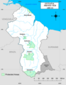 Guyana Protected Areas.png 1.224 × 1.584; 218 KB
-
 Incredible spring flora at Cavagrande.jpg 4.608 × 3.456; 9,11 MB
-
 Kumba River.jpg 4.032 × 3.024; 2,99 MB
-
 Le pont suspendu du Tsingy de l'Ankarana-Mahamasina.jpg 2.448 × 3.264; 3,11 MB
-
 Liberia Topography.jpg 713 × 703; 224 KB
-

-

-

-
 Protected area, marine and terrestrial, OWID.svg 850 × 600; 4 KB
-
 RB-zonage.png 975 × 401; 112 KB
-
 Save It.jpg 5.184 × 3.456; 4,79 MB
-
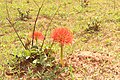
 Scadoxus multiforus 01.jpg 5.184 × 3.456; 8,81 MB
-
 Scadoxus multiforus 02.jpg 5.184 × 3.456; 8,16 MB
-
 Scadoxus multiforus 03.jpg 5.184 × 3.456; 9,86 MB
-
 Scadoxus multiforus 04.jpg 5.184 × 3.456; 10,89 MB
-
 Scadoxus multiforus 05.jpg 5.184 × 3.456; 7,97 MB
-
 Scadoxus multiforus 06.jpg 5.184 × 3.456; 8,76 MB
-
 Scadoxus multiforus 07.jpg 5.184 × 3.456; 8,77 MB
-
 Scadoxus multiforus 08.jpg 5.184 × 3.456; 7,82 MB
-
 Scinax nasicus 222539134.jpg 2.048 × 1.542; 1,99 MB
-

-
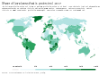 Share of land area that is protected, OWID.svg 850 × 600; 140 KB
-
 Share of marine territorial waters that are protected, OWID.svg 850 × 600; 141 KB
-

-
 The Mauritian Saint Brandon Conservation Trust Logo.png 436 × 868; 27 KB
-
 UN List of Protected Areas 2003.jpg 445 × 600; 208 KB
-
 Velky Rozsutec nov 2022.jpg 5.700 × 3.802; 13,11 MB


_by_the_World_Bank_in_1998.jpg)


