Category:Land use
Jump to navigation
Jump to search
characterization of land based on what can be built on it and what the land can be used for  | |||||
| Upload media | |||||
| Pronunciation audio | |||||
|---|---|---|---|---|---|
| Subclass of |
| ||||
| Facet of |
| ||||
| Different from | |||||
| Said to be the same as | land cover | ||||
| |||||
Subcategories
This category has the following 25 subcategories, out of 25 total.
Media in category "Land use"
The following 70 files are in this category, out of 70 total.
-
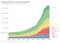
 Agricultural area over the long-term, OWID.svg 850 × 600; 31 KB
-
 Agricultural-labor-land (OWID 0030).png 850 × 600; 91 KB
-
 Agricultural-land (OWID 0024).png 850 × 600; 97 KB
-
 Agriculture-land-fao (OWID 0020).png 850 × 600; 38 KB
-
 Agriculture-more-less-land (OWID 0019).png 850 × 600; 103 KB
-
 Agrivoltaics people.jpg 1,920 × 1,080; 1.41 MB
-
 Agrivoltaics-yes.jpg 500 × 333; 180 KB
-
 Anthromes are mosaics.png 960 × 720; 1.71 MB
-

-
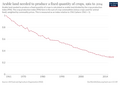
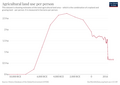
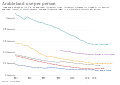 Arable land use per person, OWID.svg 850 × 600; 21 KB
-
 Arable-land-pin (OWID 0090).png 850 × 600; 57 KB
-
 ArchaeoGLOBE EXAG.gif 1,800 × 1,200; 6.84 MB
-
 ArchaeoGLOBE FHG.gif 1,000 × 666; 2.55 MB
-
 ArchaeoGLOBE INAG.gif 1,800 × 1,200; 5.86 MB
-
 ArchaeoGLOBE PAS.gif 1,000 × 666; 2.64 MB
-
 ArchaeoGLOBE URBAN.gif 1,000 × 666; 1.6 MB
-
 Area-meadows-and-pastures (OWID 0087).png 850 × 600; 107 KB
-
 Area-per-tonne-oil (OWID 0088).png 850 × 600; 61 KB
-
 Causas del cambio de uso de suelo .png 622 × 484; 57 KB
-
 Cereal-distribution-to-uses (OWID 0113).png 850 × 600; 63 KB
-
 Cereal-land-spared (OWID 0114).png 850 × 600; 58 KB
-
 Cereals-human-food-vs-gdp (OWID 0167).png 850 × 600; 120 KB
-
 Cropexpafrica oli 2019.jpg 720 × 765; 297 KB
-
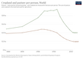 Cropland-pasture-per-person (OWID 0232).png 850 × 600; 53 KB
-
 Duero Internacional 05.jpg 4,288 × 2,848; 11.4 MB
-
 Duero Internacional 06.jpg 4,288 × 2,848; 20.72 MB
-

-
 Extent-of-extensive-agriculture (OWID 0333).png 850 × 600; 105 KB
-
 Extent-of-foraging (OWID 0335).png 850 × 600; 104 KB
-
 Extent-of-intensive-agriculture (OWID 0331).png 850 × 600; 104 KB
-
 Extent-of-pastoralism (OWID 0332).png 850 × 600; 103 KB
-
 Food-, land-, and climate change mitigation-gaps for 2050.jpg 2,813 × 719; 329 KB
-

-
 Global greenhouse gas emissions from food production.png 1,624 × 1,520; 155 KB
-
 Global-cropland (OWID 0463).png 850 × 600; 60 KB
-
 Global-land-use-graphic.png 6,251 × 3,951; 560 KB
-
 Global-land-use-since-1000bc (OWID 0540).png 850 × 600; 53 KB
-
 Global-pasture (OWID 0535).png 850 × 600; 59 KB
-
 Global-peak-agricultural-land (OWID 0532).png 850 × 600; 68 KB
-
 Globaler Fußabdruck je Einwohner.jpg 1,246 × 1,571; 367 KB
-
 Grazing land use over the long-term, OWID.svg 850 × 600; 31 KB
-
 GuangzhouOutskirtsNearLongdong2001.jpg 5,184 × 3,360; 2.17 MB
-

-
 Kastellet cph.jpg 3,664 × 1,108; 1.17 MB
-
 Kobus 2015 2070.jpg 720 × 545; 185 KB
-
 Land Use of Energy Sources per Unit of Electricity.png 1,937 × 1,791; 270 KB
-
 Land-natural-share (OWID 0594).png 850 × 600; 69 KB
-
 Land-use (OWID 0580).png 850 × 600; 33 KB
-
 Land-use-agriculture-longterm (OWID 0589).png 850 × 600; 45 KB
-
 Land-use-for-vegetable-oil-crops (OWID 0588).png 850 × 600; 76 KB
-
 Land-use-of-different-diets-Poore-Nemecek.png 2,048 × 1,259; 1.12 MB
-
 Land-use-over-the-long-term (OWID 0584).png 850 × 600; 47 KB
-
 Land-use-palm-oil (OWID 0587).png 850 × 600; 83 KB
-
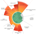
 Landusepiechart.png 537 × 501; 109 KB
-
 Landwirtschaft am Dietschiberg.jpg 3,264 × 2,448; 2.7 MB
-
 LG UNCCD.jpg 3,961 × 2,363; 3.2 MB
-
 Onset-year-intensive-agriculture (OWID 0700).png 850 × 600; 97 KB
-
 Oreo 2015 2070 Oreophryne monticola.jpg 720 × 545; 171 KB
-
 PBs2023-cs.svg 512 × 484; 126 KB
-
 PBs2023.svg 1,279 × 1,234; 310 KB
-
 Rabbitlca Graphical Abstract 5.jpg 1,280 × 720; 224 KB
-
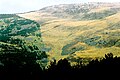
 Rascafría (1984) 03.jpg 1,060 × 715; 880 KB
-
 Share-cereal-human-food (OWID 0946).png 850 × 600; 118 KB
-
 Soria (provincia) 1998 01.jpg 1,074 × 716; 820 KB
-
 Soria (provincia) 1998 02.jpg 1,046 × 683; 1.19 MB
-
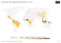
 Suitable land, land in use and surplus land in 2010, 2020 and 2030.png 1,970 × 754; 663 KB
-
 Total-agricultural-area-over-the-long-term (OWID 1038).png 850 × 600; 88 KB
-
 Total-agricultural-land-use-per-person (OWID 1037).png 850 × 600; 49 KB
-
 Land use in Vietnam.JPG 3,296 × 2,472; 1.81 MB
-
 À quoi SAFER.jpg 988 × 660; 278 KB

.png)
.png)
.png)
.png)


,_OWID.svg)

.png)


.png)
.png)

.png)
.png)
.png)

.png)


.png)
.png)
.png)
.png)


.png)

.png)
.png)
.png)


.png)
.png)
.png)
.png)

.png)
.png)


.png)


_03.jpg)
.png)
_1998_01.jpg)
_1998_02.jpg)
.png)
.png)

