File:Antarctic expedition map (Amundsen - Scott)-en.svg

Original file (SVG file, nominally 1,898 × 1,865 pixels, file size: 304 KB)
Captions
Captions
Summary
[edit]| DescriptionAntarctic expedition map (Amundsen - Scott)-en.svg |
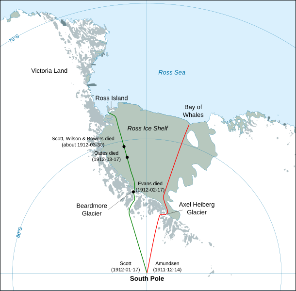
English: Map showing the polar journeys of the Scott's Terra Nova expedition (green) and Amundsen's expedition (red) to reach the South Pole
Français : Carte montrant les parcours de l'expédition Terra Nova de Scott (vert) et celle d'Amundsen (rouge) pour atteindre le Pôle Sud
Español: Mapa mostrando las travesías polares de la expedición Terra Nova de Scott (verde) y la expedición de Amundsen (rojo) para alcanzar el Polo Sur. |
| Date | |
| Source |
Own work using:
|
| Author | Shakki |
| Other versions |
[edit]
|
Licensing
[edit]| Public domainPublic domainfalsefalse |
| I, the copyright holder of this work, release this work into the public domain. This applies worldwide. In some countries this may not be legally possible; if so: I grant anyone the right to use this work for any purpose, without any conditions, unless such conditions are required by law. |
| Annotations InfoField | This image is annotated: View the annotations at Commons |
Dates should use an accessible format, suggest YYYY-MM-DD as per https://en.wikipedia.org/wiki/Wikipedia:Manual_of_Style/Dates_and_numbers#Dates,_months,_and_years
Is an SVG so should be easy to edit but cannot work out how to. The edit button on the page just seems to allow editing of metadata.
File history
Click on a date/time to view the file as it appeared at that time.
| Date/Time | Thumbnail | Dimensions | User | Comment | |
|---|---|---|---|---|---|
| current | 03:30, 29 April 2023 |  | 1,898 × 1,865 (304 KB) | Pimms1 (talk | contribs) | Changed dates to YYYY-MM-DD format |
| 21:15, 6 March 2010 |  | 1,898 × 1,865 (306 KB) | S.L. (talk | contribs) | revert | |
| 21:13, 6 March 2010 |  | 400 × 512 (2.79 MB) | S.L. (talk | contribs) | better version, mistakes fixed | |
| 18:44, 17 March 2008 |  | 1,898 × 1,865 (306 KB) | Shakki (talk | contribs) | {{Information |Description={{en|Map showing the polar journeys of the Scott's ''Terra Nova'' expedition (green) and Amundsen's expedition (red) to reach the South Pole}} {{fr|Carte montrant les parcours de l'expédition ''Terra Nova'' de Scott (vert) et c |
You cannot overwrite this file.
File usage on Commons
The following 17 pages use this file:
- File:Antarctic expedition map (Amundsen - Scott)-ar.svg
- File:Antarctic expedition map (Amundsen - Scott)-bg.svg
- File:Antarctic expedition map (Amundsen - Scott)-ca.svg
- File:Antarctic expedition map (Amundsen - Scott)-cs-colorswap.svg
- File:Antarctic expedition map (Amundsen - Scott)-cs.svg
- File:Antarctic expedition map (Amundsen - Scott)-de.svg
- File:Antarctic expedition map (Amundsen - Scott)-el.svg
- File:Antarctic expedition map (Amundsen - Scott)-en.svg
- File:Antarctic expedition map (Amundsen - Scott)-es.svg
- File:Antarctic expedition map (Amundsen - Scott)-fr.svg
- File:Antarctic expedition map (Amundsen - Scott)-he.svg
- File:Antarctic expedition map (Amundsen - Scott)-ka.svg
- File:Antarctic expedition map (Amundsen - Scott)-no.svg
- File:Antarctic expedition map (Amundsen - Scott)-ru.svg
- File:Antarctic expedition map (Amundsen - Scott)-zh-hans.svg
- File:Antarctic expedition map (Amundsen - Scott)-zh-hant.svg
- Template:Other versions/Antarctic expedition map (Amundsen - Scott)
File usage on other wikis
The following other wikis use this file:
- Usage on ar.wikipedia.org
- Usage on az.wikipedia.org
- Usage on el.wikipedia.org
- Usage on en.wikipedia.org
- Usage on en.wikivoyage.org
- Usage on es.wikipedia.org
- Usage on eu.wikipedia.org
- Usage on fa.wikipedia.org
- Usage on fi.wikipedia.org
- Usage on hu.wikipedia.org
- Usage on ja.wikipedia.org
- Usage on la.wikipedia.org
- Usage on mk.wikipedia.org
- Usage on nl.wikipedia.org
- Usage on pl.wikipedia.org
- Usage on pt.wikipedia.org
- Usage on ro.wikipedia.org
- Usage on simple.wikipedia.org
- Usage on sr.wikipedia.org
- Usage on zh.wikipedia.org
Metadata
This file contains additional information such as Exif metadata which may have been added by the digital camera, scanner, or software program used to create or digitize it. If the file has been modified from its original state, some details such as the timestamp may not fully reflect those of the original file. The timestamp is only as accurate as the clock in the camera, and it may be completely wrong.
| Width | 1897.8101 |
|---|---|
| Height | 1865.48 |


