File:Cyp.PNG
Jump to navigation
Jump to search
No higher resolution available.
Cyp.PNG (630 × 321 pixels, file size: 20 KB, MIME type: image/png)
Captions
Captions
Add a one-line explanation of what this file represents
Summary
[edit]
| Description |
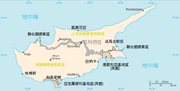
中文:賽普勒斯地圖. 在這幅塞浦路斯島的地圖上,可以看到灰色的聯合國緩衝區貫穿全島,將島上分隔為南北兩地區。. |
| Source | CIA World Fact Book |
| Author | CIA |
Licensing
[edit]
This image is in the public domain because it contains materials that originally came from the United States Central Intelligence Agency's World Factbook.
|
 |
Original upload log
[edit]
The original description page was here. All following user names refer to zh.wikipedia.
- 2005-08-03 05:50 Ffootballchu 630×321×8 (20135 bytes)
File history
Click on a date/time to view the file as it appeared at that time.
| Date/Time | Thumbnail | Dimensions | User | Comment | |
|---|---|---|---|---|---|
| current | 10:05, 28 May 2008 | | 630 × 321 (20 KB) | Noahv (talk | contribs) | {{Information |Description={{zh|''no original description''}} |Source=Transferred from [http://zh.wikipedia.org zh.wikipedia]; transfer was stated to be made by User:noahv. |Date=2005-08-03 (original upload date) |Author=Original uploader was [[:zh:Us |
You cannot overwrite this file.
File usage on Commons
There are no pages that use this file.
File usage on other wikis
The following other wikis use this file:
- Usage on ami.wikipedia.org
- Usage on zh-yue.wikipedia.org
- Usage on zh.wikipedia.org