File:Map Crusader states 1102-it.svg
Jump to navigation
Jump to search

Size of this PNG preview of this SVG file: 513 × 599 pixels. Other resolutions: 205 × 240 pixels | 411 × 480 pixels | 658 × 768 pixels | 877 × 1,024 pixels | 1,754 × 2,048 pixels | 591 × 690 pixels.
Original file (SVG file, nominally 591 × 690 pixels, file size: 716 KB)
Captions
Captions
Add a one-line explanation of what this file represents
| Description |
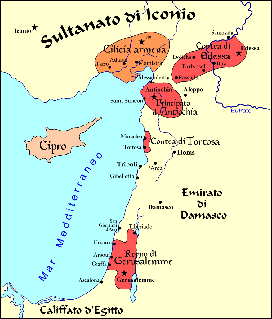
Italiano: Carta politica del Vicino oriente nel 1102, subito dopo la Prima Crociata.
Français : Carte politique du Proche-Orient en 1102, juste après la Première Croisade. |
| Date | (UTC) |
| Source | |
| Author | |
| Other versions |
[]
See also[edit] |


| This is a retouched picture, which means that it has been digitally altered from its original version. Modifications: translation into italian language. The original can be viewed here: Map Crusader states 1102-fr.svg:
|
I, the copyright holder of this work, hereby publish it under the following licenses:
This file is licensed under the Creative Commons Attribution-Share Alike 3.0 Unported, 2.5 Generic, 2.0 Generic and 1.0 Generic license.
- You are free:
- to share – to copy, distribute and transmit the work
- to remix – to adapt the work
- Under the following conditions:
- attribution – You must give appropriate credit, provide a link to the license, and indicate if changes were made. You may do so in any reasonable manner, but not in any way that suggests the licensor endorses you or your use.
- share alike – If you remix, transform, or build upon the material, you must distribute your contributions under the same or compatible license as the original.

|
Permission is granted to copy, distribute and/or modify this document under the terms of the GNU Free Documentation License, Version 1.2 or any later version published by the Free Software Foundation; with no Invariant Sections, no Front-Cover Texts, and no Back-Cover Texts. A copy of the license is included in the section entitled GNU Free Documentation License. |
You may select the license of your choice.
Original upload log[edit]
This image is a derivative work of the following images:
- File:Levant_1102-fr.svg licensed with Cc-by-sa-3.0,2.5,2.0,1.0, GFDL
- 2008-06-01T23:20:21Z Odejea 591x690 (635927 Bytes) bleu
- 2008-05-28T21:14:01Z Odejea 591x690 (635927 Bytes) {{Information |Description= |Source= |Author= |Date= |Permission= |other_versions= }}
- 2008-05-28T21:11:36Z Odejea 591x690 (594011 Bytes) {{Information |Description= |Source= |Author= |Date= |Permission= |other_versions= }}
- 2008-05-28T21:06:28Z Odejea 591x690 (528519 Bytes) {{Information |Description= |Source= |Author= |Date= |Permission= |other_versions= }}
- 2008-05-28T21:03:08Z Odejea 591x690 (416701 Bytes) {{Information |Description= |Source= |Author= |Date= |Permission= |other_versions= }}
- 2008-05-28T21:01:21Z Odejea 591x690 (349758 Bytes) {{Information |Description= |Source= |Author= |Date= |Permission= |other_versions= }}
- 2008-05-28T20:59:28Z Odejea 591x690 (279879 Bytes) {{Information |Description= |Source= |Author= |Date= |Permission= |other_versions= }}
- 2008-05-28T20:57:38Z Odejea 591x690 (43595 Bytes) {{Information |Description= |Source= |Author= |Date= |Permission= |other_versions= }}
- 2008-05-28T20:23:11Z Odejea 591x690 (653191 Bytes) {{Information |Description={{en|1=A political map of the [[w:en:Near East]] in 1102 [[w:en:Common Era|CE]].}} {{fr|1=Carte politique du [[w:fr:Proche-Orient|Proche-Orient]] en 1102, juste après la Première Croisade.}} |Sour
Uploaded with derivativeFX
File history
Click on a date/time to view the file as it appeared at that time.
| Date/Time | Thumbnail | Dimensions | User | Comment | |
|---|---|---|---|---|---|
| current | 11:21, 25 July 2009 | | 591 × 690 (716 KB) | Franco aq (talk | contribs) | {{Information |Description={{en|1=A political map of the w:en:Near East in 1102 CE.}} {{fr|1=Carte politique du Proche-Orient en 1102, juste après la Première Croisade.}} |Source=*[[:File:Levant_1102-fr.svg |
You cannot overwrite this file.
File usage on Commons
The following 9 pages use this file:
- File:Levante 1102-it.svg (file redirect)
- File:Map Crusader states 1102-en.svg
- File:Map Crusader states 1102-es.svg
- File:Map Crusader states 1102-fr.svg
- File:Map Crusader states 1102-hu.svg
- File:Map Crusader states 1102-it.svg
- File:Map Crusader states 1102-pt.svg
- File:Map Crusader states 1102-ru.svg
- Template:Other versions/Map Crusader states 1102
File usage on other wikis
The following other wikis use this file:
- Usage on it.wikipedia.org
- Usage on sr.wikipedia.org
- Usage on tr.wikipedia.org
Categories:
- Maps of Cilicia
- Maps of the County of Edessa
- Maps of the County of Tripoli
- Maps of the crusades
- Maps of the Kingdom of Jerusalem
- Maps of the Principality of Antioch
- Maps of the history of Cyprus
- Maps of the history of the Levant
- Maps of the history of the Middle East
- Maps showing 12th-century history
- Italian-language SVG maps showing history