File:Twin Cities Metro Area (13 County).png
Jump to navigation
Jump to search

Size of this preview: 775 × 600 pixels. Other resolutions: 310 × 240 pixels | 620 × 480 pixels | 992 × 768 pixels | 1,280 × 991 pixels | 1,500 × 1,161 pixels.
Original file (1,500 × 1,161 pixels, file size: 866 KB, MIME type: image/png)
Captions
Captions
Add a one-line explanation of what this file represents
Summary
[edit].png&action=edit§ion=1)
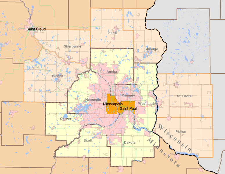
| Description | Minneapolis-Saint Paul (Twin Cities) highlighting both the 7-county Urban Area (traditional) and the revised 13-county Metropolitan Statistical Area from the 2000 Census. Today, the term Twin Cities typically refers to the metropolitan area. The pink areas represent urbanized areas as defined by the Metropolitan Council (urbanized meaning developed with sewer access and includes suburbia and small towns). The red and green lines are highways while the grid-like lines within the counties are township boundaries and mostly rural. Suburban cities are also defined within the pink area however they are not as apparent since their borders so regularly match up with existing highways and natural features. |
| Date | |
| Source | Own work by uploader using publicly and freely available cartographic data by state and private agencies. Raster by MapInfo, purchased for personal use and distributed for no monetary gain. |
| Author | Davumaya |
| Permission (Reusing this file) |
Agencies providing this data and myself make no assertion that this data is an accurate representation or legally defined. It is provided as a fair representation and should not be used for legal purposes. |
Licensing
[edit].png&action=edit§ion=2)
I, the copyright holder of this work, hereby publish it under the following license:
This file is licensed under the Creative Commons Attribution-Share Alike 3.0 Unported license.
- You are free:
- to share – to copy, distribute and transmit the work
- to remix – to adapt the work
- Under the following conditions:
- attribution – You must give appropriate credit, provide a link to the license, and indicate if changes were made. You may do so in any reasonable manner, but not in any way that suggests the licensor endorses you or your use.
- share alike – If you remix, transform, or build upon the material, you must distribute your contributions under the same or compatible license as the original.
File history
Click on a date/time to view the file as it appeared at that time.
| Date/Time | Thumbnail | Dimensions | User | Comment | |
|---|---|---|---|---|---|
| current | 21:27, 12 August 2008 | | 1,500 × 1,161 (866 KB) | Davumaya (talk | contribs) | {{Information |Description= |Source= |Date= |Author= |Permission= |other_versions= }} <!--{{ImageUpload|basic}}--> |
| 21:22, 12 August 2008 |  | 2,000 × 1,545 (238 KB) | Davumaya (talk | contribs) | {{Information |Description=Minneapolis-Saint Paul (Twin Cities) highlighting both the 7-county Urban Area (traditional) and the revised 13-county Metropolitan Statistical Area from the 2000 Census. |Source=Own work by uploader using publicly and freely a |
You cannot overwrite this file.
File usage on Commons
There are no pages that use this file.
File usage on other wikis
The following other wikis use this file:
- Usage on de.wikipedia.org
- Usage on en.wikipedia.org
- Usage on fi.wikipedia.org
- Usage on ja.wikipedia.org
- Usage on nl.wikipedia.org
- Usage on pl.wikipedia.org
- Usage on ro.wikipedia.org
- Usage on simple.wikipedia.org
- Usage on sv.wikipedia.org
- Usage on vi.wikipedia.org
.png&oldid=547059610)