File:'Confederate General Lewis Armistead at The Angle' -- Gettysburg (PA) Cyclorama 2012.jpg
Fichier d’origine (2 397 × 1 379 pixels, taille du fichier : 703 kio, type MIME : image/jpeg)
Légendes
Légendes
Description
[modifier]_Cyclorama_2012.jpg&action=edit§ion=1)
| Description |
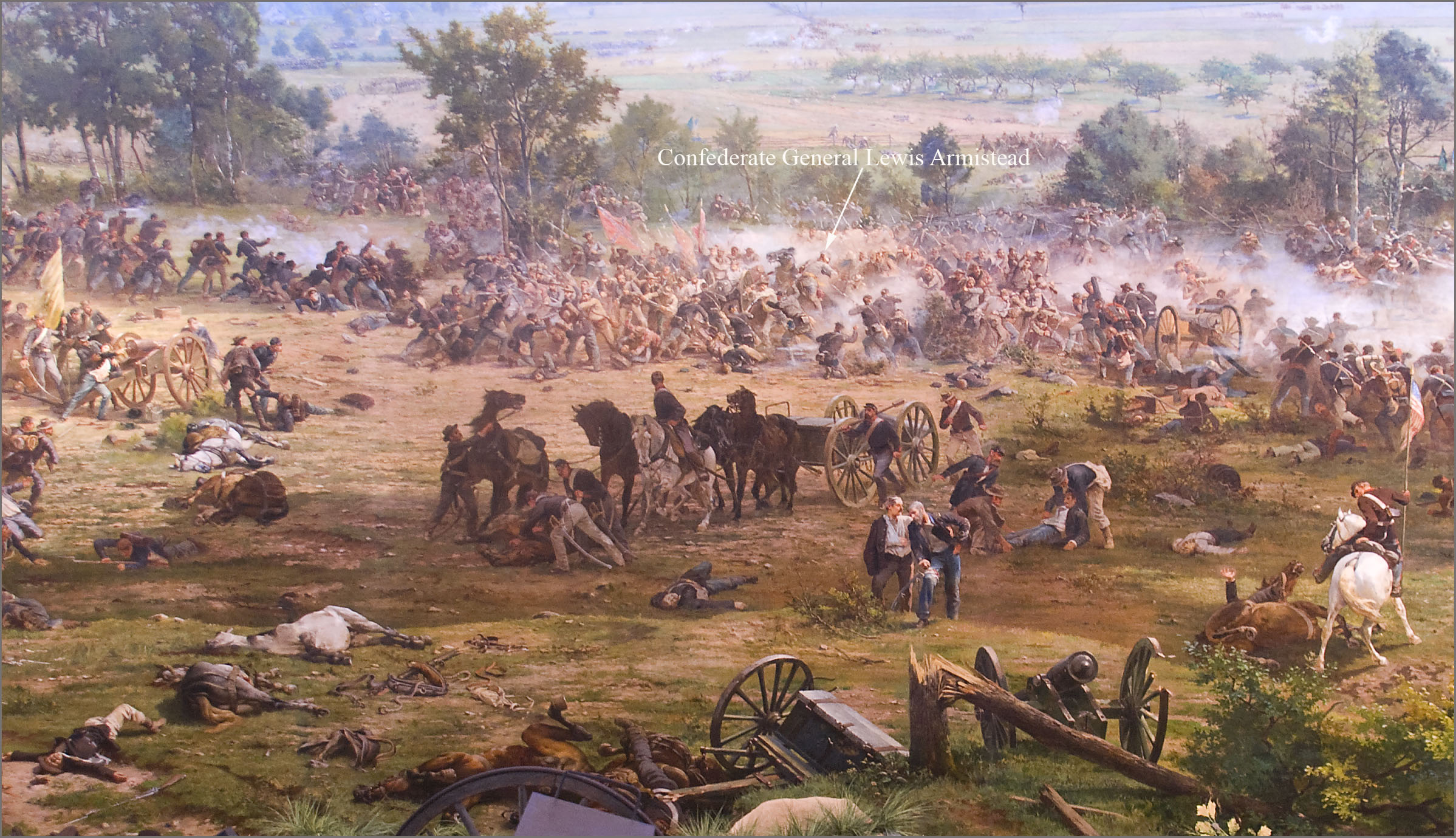
English: 'The Battle of Gettysburg', also known as the Gettysburg Cyclorama, is a cyclorama painting by the French artist Paul Philippoteaux depicting "Pickett's Charge", the climactic Confederate attack on the Union forces on Cemetery Ridge during the Battle of Gettysburg on Friday afternoon July 3, 1863.
The section of the Cyclorama shown above depicts Confederate General Lewis Armistead struck by rifle fire while leading his brigade in a break-through of the Union infantry line on Cemetery Ridge at an area known as "The Angle". Armistead's brigade arrived at Gettysburg on the evening of July 2nd. As part of the Pickett-Pettigrew Charge on the 3rd, Armistead led his brigade from the front on foot (not on a horse as portrayed above), waving his hat from the tip of his saber, and reaching and climbing over the stone wall at the "Angle", which served as the Charge's objective. Armistead was shot three times just after crossing the stone wall. However, his wounds were initially not believed to be mortal, being shot in the fleshy part of the arm and below the knee. He was eventually taken to a Union field hospital at the George Spangler Farm where he died two days later. The chief surgeon at the Union hospital there had expected Armistead to survive because he characterized the two bullet wounds as not serious. He wrote that the death "was not from his wounds directly, but from secondary fever and prostration". Image at 7:15 pm July 28, 2012, by Ron Cogswell using a hand-held Nikon D80 at 1/6 sec., f/3.5, ISO 400, and 18 mm, during an after-hours presentation on the Gettysburg Cyclorama conducted by Chris Brennaman. |
| Date |
Painting:1883 Photograph: 2012-07-28 |
| Source | https://www.flickr.com/photos/22711505@N05/7694930148/ |
| Auteur | Ron Cogswell |
| Lieu de la prise de vue | | Voir cet endroit et d’autres images sur : OpenStreetMap |
|---|
_Cyclorama_2012.jpg¶ms=039.811568_N_-077.226054_E_globe:Earth_type:camera__&language=fr)
Conditions d’utilisation
[modifier]_Cyclorama_2012.jpg&action=edit§ion=2)
| Cette image a été publiée sur Flickr. Sa licence a été vérifiée comme "cc-by-2.0" par l'extension UploadWizard au moment où elle a été transférée sur Wikimedia Commons. Voir les informations de licence pour plus de détails. |
- Vous êtes libre :
- de partager – de copier, distribuer et transmettre cette œuvre
- d’adapter – de modifier cette œuvre
- Sous les conditions suivantes :
- paternité – Vous devez donner les informations appropriées concernant l'auteur, fournir un lien vers la licence et indiquer si des modifications ont été faites. Vous pouvez faire cela par tout moyen raisonnable, mais en aucune façon suggérant que l’auteur vous soutient ou approuve l’utilisation que vous en faites.
Historique du fichier
Cliquer sur une date et heure pour voir le fichier tel qu'il était à ce moment-là.
| Date et heure | Vignette | Dimensions | Utilisateur | Commentaire | |
|---|---|---|---|---|---|
| actuel | 18 août 2013 à 02:38 | | 2 397 × 1 379 (703 kio) | Jarekt (d | contributions) | User created page with UploadWizard |
Vous ne pouvez pas remplacer ce fichier.
Utilisations locales du fichier
La page suivante utilise ce fichier :
Utilisations du fichier sur d’autres wikis
Les autres wikis suivants utilisent ce fichier :
- Utilisation sur de.wikipedia.org
- Utilisation sur en.wikipedia.org
- Utilisation sur ja.wikipedia.org
- Utilisation sur ru.wikipedia.org
- Utilisation sur sv.wikipedia.org
_Cyclorama_2012.jpg&oldid=732874718)